
East Creek Reserve
Buy the $.99 downloadable map!
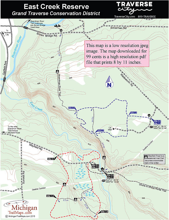
(This map is not geo-referenced)Trail Details


The reserve is also open to cross-country skiing and snowshoeing though winter access is much more limited. Mayfield Road, one of two access roads to the park, becomes Snowmobile Trail No. 510 from December through March and is impassable by vehicles.
East Creek’s trail system forms two separate loops connected by a 0.3-mile spur that climbs steeply from the creek bed to the crest of a towering ridge. The perimeter of Mayfield Road loop makes for a 2.2-mile outing, the Wadsworth Road loop is shorter at 1.5 miles. Both are described here as separate trails.
Utilizing a segment of East Creek’s trail system is the new Boardman River Trail. Proposed in 2010, the Boardman River Trail will extend 24 miles when completed from Traverse City to the North Country Trail (NCT) at Munice Lakes Pathway. From the NCT users can continue on to connect with the Vasa Pathway and head back to Traverse via the TART Trail, resulting in a 46-mile loop.
The first segment of the Boardman River Trail was completed in 2013 and extends from Mayfield Pond Park to East Creek Reserve via Mayfield Road. It then follows portions of both of the reserve’s loops, and the steep spur between them, before departing the Wadsworth Road loop and following newly constructed single-track trail north to Brown Bridge Quiet Area.
| Difficulty - Easy |
| Dog Friendly |
| Foot Path |
Geo-referenced maps from MichiganTrailMaps.com range from $1.99 to $2.99 each.
Download the Avenza app from the App Store or Google Play


