320

Trails Reviewed

Find Trails & Maps

Search for Trail
Search by Location
Search by

Back to listing

Hickory Meadows

Trail Details

County
Grand Traverse
Regions
Northwest
Latitude
N 44° 46' 26.40"
Longitude
W 085° 39' 23.04"
Distance
2.2 miles
Trail Type
Foot path, cross-country ski trail
Terrain
Meadows, woodlands
Difficulty
Easy
Nearest City or Town
Traverse City
(map loads here)
view map
Hickory Meadows is a classic urban trail system that is perched high above city neighborhoods but bounded on three sides by even taller hills. It offers 2 miles of unpaved paths that wander over hills, across meadows and through woodlands. Overall the hiking is easy but the park is located at the foot of the Hickory Hills Ski Area where the ambitious can finished their outing with a 230-foot climb to the top of Hickory Hill itself. In the summer, Hickory Meadows is a popular destination for hikers, dog walkers and families looking for an easy outing on their mountain bikes. In the winter cross-country skiers arrive to follow the well-marked trail system along skier-set tracks.
Expand All
Photos
Description
There was a time when Hickory Meadows was little more than upland forests and wooded swamp wetlands. But following a period of logging in the mid-1800s, this series of connected meadows in the hills above Traverse City’s West Side became a cornucopia of agricultural goodness; tart and sweet cherries, peaches, apples, cabbage, tomatoes, and squash. In the 1930’s, grocer Jerry Oleson purchased 130 acres and added alfalfa to feed his growing buffalo herd that eventually expanded to over 900.

The Oleson family also allowed hikers, bikers and dog owners to access to the fields and for decades Hickory Meadows was locally known as a quick escape from the city that now surrounds it. Today it’s a permanent escape. In 2004, voters of Traverse City and Garfield Township approved a tax millage that turned these interlocking fields into a 112.5-acre park.

Hickory Meadows is a classic urban trail system that is perched high above city neighborhoods but bounded on three sides by even taller hills. It offers 2 miles of unpaved paths that wander over hills, across meadows and through woodlands. Overall the hiking is easy but the park is located at the foot of the Hickory Hills Ski Area where the ambitious can finished their outing with a 230-foot climb to the top of Hickory Hill itself.

In the summer, Hickory Meadows is a popular destination for hikers, dog walkers and families looking for an easy outing on their mountain bikes. In the winter cross-country skiers arrive to follow the well-marked trail system along skier-set tracks.

Adjacent to Hickory Meadows is Hickory Hills Ski Area. Along with its eight downhill runs and five rope tows, the city-owned ski area also has 5 kilometers of cross-country trails, including a kilometer lit for night skiing, spread over its 125 acres of rolling terrain and ridges. Occasionally in the winter the staff at Hickory Hills will also groom a 0.8-mile loop in Hickory Meadows that skiers pick up from the Randolph Street trailhead on the west side of the park. Future plans call for connecting the two trail systems.

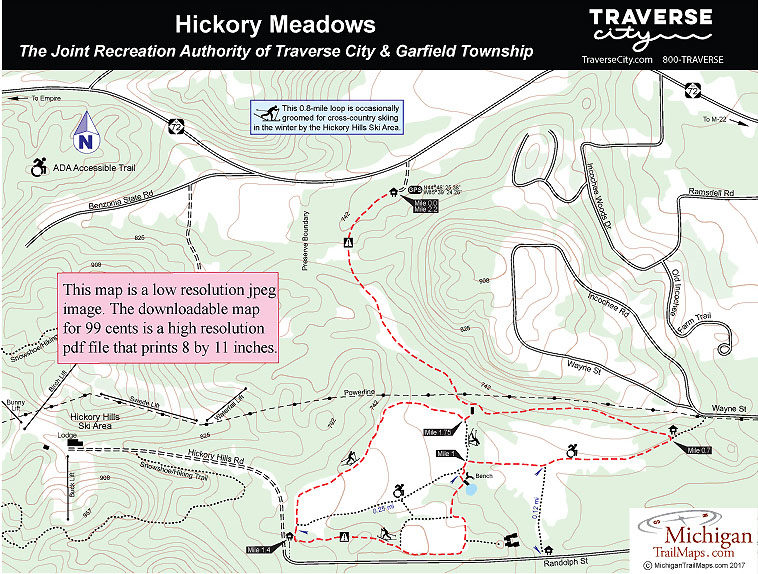
The route described here begins at the M-72 trailhead and follows the perimeter of the Hickory Meadows trail system. You double back on the first leg to return to your vehicle but this outing is still only a 2.2-mile effort.
Amenities & Services
Difficulty - Easy
Dog Friendly
Foot Path
Trail Guide

Other than a historic red barn and a boot cleaner device there are no facilities at the M-72 trailhead. In the summer bring water. The trail begins with a long downhill that could befuddle a few skiers in the winter and bottoms out in the first meadow. After passing underneath a power line, at Mile 0.4 you arrive a junction and a foot bridge over a usually dry stream in a cathedral of tall pines. Continue east (left) to skirt the base of what is often referred to as Wayne Hill before another downhill ends at a junction at Mile 0.7.

A hundred yards or so to the east is the Wayne Street trailhead. Head west (right) to cut across one of the park’s two main meadows along a wide, gravelly trail. After passing a spur that heads south to a trailhead on Randolph Street, you pass through a windbreak of old-growth hardwoods and at Mile 1 arrive at a junction. To the right a two-track heads north, to the left is one end of the Handicap Accessible Trail and nearby a wooden stairway to a small, cattail-choked pond. Overlooking it are a pair of benches where you can sit and listen to frogs croaking.

Continuing south from the pond, the trail eventually curves west, climbs a noticeable hill with a long downhill on the other side that ends at the main trailhead on Randolph Street. Reached at Mile 1.4, the trailhead marks where the wide, hard-packed Handicap Accessible Trail heads west across the park’s main meadow.

Another trail here heads north to skirt the large open field. The meadow is partially ringed in by the high hills of the ski area and nowhere in sight is the city or the urban sprawl that surrounds this park. At Mile 1.75 you arrive at a junction with a two track where just to the north (right) is the foot bridge passed earlier. This time you cross it and backtrack along the first leg of loop to return to the M-72 trailhead at Mile 2.2.

Facilities

The M-72 and main Randolph Street trailheads feature parking and information boards but not restrooms or drinking water. Dogs are welcome but must be leashed.

Hours & Fees

There are no vehicle or entry fees at Hickory Meadows.

Directions

Hickory Meadows can be accessed by four trailheads. From M-22 along the West Bay, head west almost a mile on M-72 to the posted entrance of a trailhead on the south side of the state highway featuring a large red barn. There is also a nearly hidden path that starts at the edge of someone’s driveway on Wayne Street, 0.6 miles from the bay.

Another obscured trailhead is on the north side of Randolph Street, a mile west of Bay Street in the downtown area while the most popular trailhead is further west at the top of Randolph Street, near the entrance to Hickory Hills ski area.

Information

For more information contact the Grand Traverse Conservation District at 231-941-0960.

For lodging or travel information contact Traverse City Tourism (800-872-8377; www.traversecity.com).


Geo-referenced maps from MichiganTrailMaps.com range from $1.99 to $2.99 each.

Download the Avenza app from the App Store or Google Play

App Store Google Play

Michigan TrailMaps.com Michigan's Premier Trail Resource Contact

Trail Mix News

by travel and outdoor writer Jim DuFresne!

Sign Up
Enews Signup
Find a Trail

Find Trails & Maps

Search for Trail
Search by Location
Search by