320

Trails Reviewed

Find Trails & Maps

Search for Trail
Search by Location
Search by

Back to listing

North Western State Trail: Petoskey to Alanson

Trail Details

County
Emmet
Regions
Northwest
Latitude
N 45° 23' 37.32"
Longitude
W 084° 54' 23.04"
Distance
7.5 miles
Trail Type
Paved trail
Terrain
Round Lake, Crooked Lake
Difficulty
Easy
Nearest City or Town
Petoskey
(map loads here)
view map
The North Western State Trail the Fishing Line portion of the Grand Rapids Indiana Railroad from the 1880s extends 32 miles from near Petoskey to Mackinaw City. But the crowning jewel of the trail is the segment from the Spring Lake to Alanson. This 7.5-mile stretch would be for the most scenic and interesting portion of the rail trail whether it was paved or not.But it is, much to the joy of those who arrive with road bikes, inline skates or two toddlers in a dual stroller.Resurfaced in 2012 as a 10-foot wide asphalt path, the trail begins at Spring Lake Park on M-119, skirts the shores of four inland lakes, passes through the lakeside hamlets of Conway and Oden and provides access t ...
Expand All
Photos
Description

The North Western State Trail – the Fishing Line portion of the Grand Rapids & Indiana Railroad from the 1880s – extends 32 miles from near Petoskey to Mackinaw City. But the crowning jewel of the trail is the segment from the Spring Lake to Alanson. This 7.5-mile stretch would be for the most scenic and interesting portion of the rail trail whether it was paved or not.

But it is, much to the joy of those who arrive with road bikes, inline skates or two toddlers in a dual stroller.

Resurfaced in 2012 as a 10-foot wide asphalt path, the trail begins at Spring Lake Park on M-119, skirts the shores of four inland lakes, passes through the lakeside hamlets of Conway and Oden and provides access to eight preserves and parks including the historic Oden State Fish Hatchery.  Along the way there are plenty of places to spot and admire the view or grab a well-earned snack or lunch.

Additional paved miles are easy to add. On the west side of M-119 from Spring Lake Park – and reached via a pedestrian crossing – is the Little Traverse Wheelway that extends 23 miles from Charlevoix to Harbor Springs. From Spring Lake downtown Petoskey is 3 miles south along the Little Traverse Wheelway, Harbor Springs is 6 miles to the north.

Amenities & Services
Difficulty - Easy
Dog Friendly
Paved Trail
Trail Guide

From the north end of Spring Lake, The North Western State Trail departs its trailhead to immediately cross Konle Road and then skirt Mud Lake. At either lake you can pause and search the shoreline and surrounding wetlands for winged wildlife. Beyond Mud Lake, the rail-trail crosses Hiawatha Trail and enters South Round Lake Nature Preserve, a 10-acre tract at the south end of the lake.

South Round Lake and six other nature preserves that are either along the trail or are quickly accessed from it are managed by the Little Traverse Conservancy. The conservancy includes more than 172 nature preserves spread across five counties in both the Lower and Upper Peninsula. For more about the preserves including those along the North Western State Trail contact Little Traverse Conservancy (231-347-0991).

The rail-trail follows the east shoreline of Round Lake for almost a mile while paralleling Hiawatha Trail and at Mile 1.5 arrives at Little Traverse Conservancy’s Fochtman Nature Preserve, a 243-acre tract. A trailhead here marks a foot trail that follows the east shore to reach an overlook of Round Lake in less than a quarter mile.   

At Mile 2.5, the North Western reaches W. Conway Road. Just 300 yards to west on W. Conway Road is a trailhead for Hailand Nature Preserve, marking another short foot path to a scenic wetland. Just to the east is Conway on the west end of Crooked Lake. The lakefront village has restaurants and shops along US-31 and a public beach on Crooked Lake at Little Traverse Township Park.

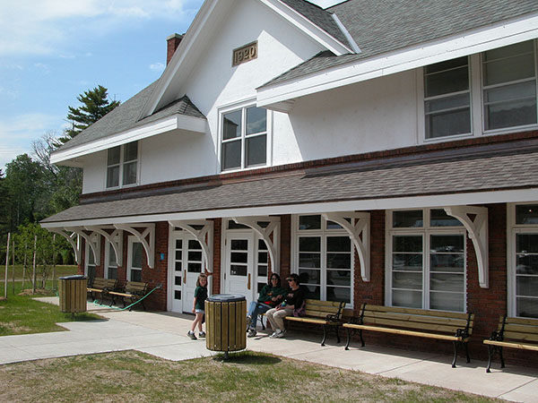
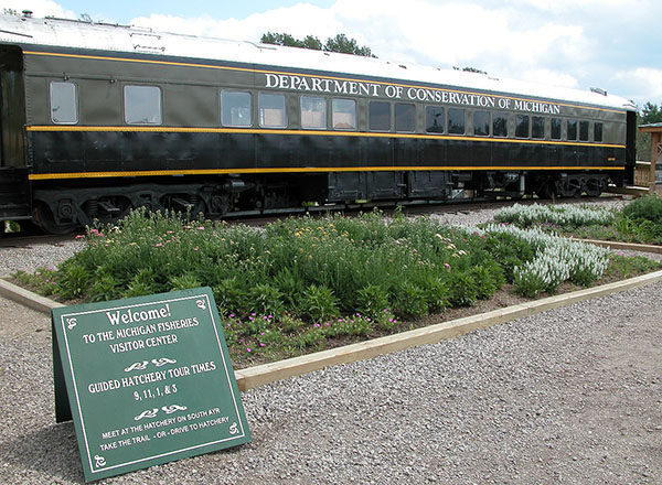
Beyond Conway, the North Western passes the west side Hailand Nature Preserve and then begins paralleling US-31, arriving at the Oden State Fish Hatchery at Mile 3.9.  After replacing the 80-year-old hatchery in 2002 with a new facility a half mile to the north, the state spent $2 million to turn the original site into the Michigan Fisheries Visitor Center with trails, displays and a viewing chamber that puts visitors eye-to-eye with a trout. Adjacent to the visitor center is the re-created 1914-1935 Wolverine train car with historic exhibits that depict how employees of the old Michigan Department of Conservation lived on the train while transporting and stocking fish across the state. Also at the center are restrooms, picnic tables and drinking water.

The village of Oden is reached at Mile 4.8, where there are restaurants, shops and views of Oden Island in the center of Crooked Lake. A half mile west of Oden the trail crosses Blumke Road and then leaves the railroad bed via a boardwalk to hug US-31 for the next 1.5 miles.

Powers Road is reached at Mile 6.9 and here the paved path ends and the North Western becomes a shared road route with Milton Road for the remaining half mile to Alanson. Straddling the Crooked River, Alanson has a wide range of stores and restaurants, from sandwich shops and bakeries to taverns for a beer and a burger.  There is also lodging, the Inland Waterway Route Historical Museum (231-548-5716), the Crooked River locks and Sanctuary Island Park where at the end of East Street a hand propelled ferry takes you to an island boardwalk trail.

Bathrooms and parking are available next to Littlefield Alanson Community Building  on the east side of US-31. Follow Milton Road through town to resume on the North Western State Trail which becomes a compacted limestone path after Chicago Street. It is 8 miles to Pellston and 24.5 miles to Mackinaw City and is covered on another section of this web site

Facilities

The trail begins at Spring Lake Park on M-119 where there is parking, restrooms, an interpretive trail and picnic facilities. There are also restrooms, drinking water and parking at the Michigan Fisheries Visitors Center in Oden and restaurants and convenience stores in the villages of Conway, Oden and Alanson.

Hours & Fees

The North Western State Trail is open to all non-motorized uses year-round, and to snowmobiles from December 1 to March 31.

Directions

Spring Lake Park anchors the southern end and is reached from US-31 by heading north from Petoskey and then continuing north (left) on M-119. Within a half mile the park will be posted on the right. The Michigan Fisheries Visitors Center on US-31 in Oden also serves as a trailhead. 

Information

For more information on the trail contact the Top of Michigan Trails Council (231-348-8280). For more on lodging and other attractions in the area contact the Petoskey Area Visitors Bureau (800-845-2828; www.petoskeyarea.com)


Geo-referenced maps from MichiganTrailMaps.com range from $1.99 to $2.99 each.

Download the Avenza app from the App Store or Google Play

App Store Google Play

Michigan TrailMaps.com Michigan's Premier Trail Resource Contact

Trail Mix News

by travel and outdoor writer Jim DuFresne!

Sign Up
Enews Signup
Find a Trail

Find Trails & Maps

Search for Trail
Search by Location
Search by