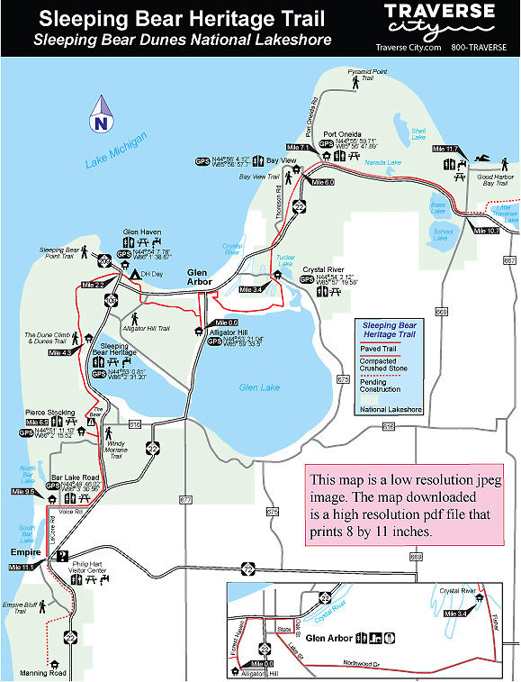
Glen Arbor to Empire
The ride from Glen Arbor to Empire is an 11.1-mile outing, with the first section to the Dune Climb by far the busiest stretch of the Heritage Trail. For a detailed map of this section click here.
In Glen Arbor, the trail shares the trailhead with the Alligator Hill Trail on Forest Haven Drive, 300 yards west of M-22. There are no facilities except parking.
Head north on Forest Haven Drive to pick up the well-posted Heritage Trail within a third of a mile and then west on the paved path into a forest that was devastated by the August 2015 storm. Though the trail skirts Alligator Hill at this point, it remains a level ride in the summer and an easy ski in the winter. The Heritage Trail crosses M-109, a busy state highway in the summer, at Mile 1.9 and then skirts D.H. Campground, where there is access to toilets, drinking water, a beautiful beach and a picnic area.
At Mile 2.2, the trail enters historic Glen Haven and crosses M-209. Founded in 1857 when a sawmill was built, Glen Haven was developed as a deep-water port to service shipping traffic with firewood, lumber and other supplies.
The most distinctive building seen from the trail is the bright red Glen Haven Canning Company structure. Originally built as a warehouse, it was converted to what was then a state-of-the-art cannery for cherries in the early 1920s. Today it is a seasonal maritime museum filled with historic boats that once plied the waters between Glen Haven and the Manitou Islands. Nearby is a fully restored blacksmith shop and the Glen Haven General Store. All three museums are open daily from Memorial Day weekend through Labor Day.
After crossing M-209, the trail enters a semi-open meadow and begins a long, gentle climb, topping out at the west end of Dunes Valley Road at Mile 3 where it swings south and re-enters the woods. A gentle descent leads past the D. H. Day Group Campground, where toilets and drinking water are available.
You then pass some of the trail’s most impressive terrain. On one side of the trail is a lush green forest, on the other a towering dune so steep that occasionally small avalanches of snow rumble down it. The Heritage Trail merges into the park’s Duneside Accessible Trail, a half-mile path featuring a series of interpretive displays and benches, before arriving at the Dune Climb at Mile 4.3.
The Heritage Trail departs the Dune Climb to the south and within a mile changes from flat to hilly. The first steep hill is encountered at Mile 5.8 where there is a bench at the top. You descend to Greenan Road, follow it briefly to the west (right) and then continue south by climbing the longest hill of the ride, one that gains almost 100 feet in a quarter mile. Nicknamed “the Bear,” it is lined with benches. You reach a spur to the Pierce Stocking Trailhead at Mile 6.9.
After crossing Pierce Stocking Drive, the Heritage Trail climbs again, followed by a long and pleasant downhill run. For the next 1.6 miles, cyclists enjoy a free ride that includes speeding past the M-22 and M-109 intersection. At Mile 9, the trail swings west and climbs one more hill before arriving at the intersection of Voice Road and Bar Lake Road, reaching the Bar Lake Road Trailhead at Mile 9.5. North Bar Lake, a popular day-use area and beach, is 1.4 miles to the north via Bar Lake Road. The Heritage Trail swings south at LaCore Road and ends. You follow LaCore Road south to Empire, reaching the Philip Hart Visitor Center at Mile 11.1.
For those using the BATA Bike-N-Ride service, the bus stops in Empire at the gas station on the corner of M-22 and M-72.
Glen Arbor to Good Harbor Bay
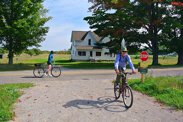
East of Glen Arbor, the Heritage Trail follows roads through town and for 3.4 miles to the Crystal River Trailhead. From the Alligator Hill Trailhead, head north on Forest Haven Drive and then east (right) on M-109 and M-22 through the heart of downtown Glen Arbor. Keep a watchful eye on traffic! There is a dedicated bike lane along M-22 but in the summer, especially on weekends, this five-block stretch often bustles with cars, pedestrians and cyclists.
Turn south (right) on Oak Street to escape the maddening summer scene and then west (right) for a block on State Street. Turn south (left) on Lake Street and within a third of a mile go east (left) on Northwoods Drive, a pleasant road to pedal because of its leafy canopy and light traffic. The north shore of Glen Lake is just to the south but usually hidden by homes and foliage. At Mile 3, turn north (left) on Fisher Road and in less than a half mile you cross over beautiful Crystal River and arrive at the Crystal River Trailhead.
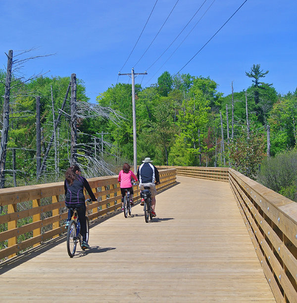
From the trailhead the Heritage Trail briefly skirts County Road 675 as a dedicated paved path before crossing it and heading north into the wetlands west of Tucker Lake. An impressive 800-foot boardwalk provides passage and makes for an ideal place to pause and look for wildlife. At Mile 4.3, the Heritage Tail crosses M-22 near the Homestead Resort.
Another hilly stretch is encountered after crossing M-22. You immediately climb a hill and then descend to Thoreson Road, where post No. 9 of Bay View Trail is located. You climb again and then enjoy a long downhill run. At Mile 5.5 is post No. 6, where the surface changes from asphalt to compacted crushed limestone as the Heritage Trail enters the Port Oneida Rural Historic District.
At Mile 6, the Heritage Trail crosses Thoreson Road, which leads west to the Bay View Trailhead, and in another half mile arrives at the Charles Olsen Farm with its impressive red barn and steel and wooden silo. The classic farmhouse and barn were built in 1918 and have since been restored by the National Park Service.
Continuing in a northeast direction, the Heritage Trail passes post No. 3, marking a spur of the Bay View Trail that leads a half mile up a ridge to Lookout Point. Just beyond it you arrive at Port Onieda Road at Mile 7.1. On the west side of the road is the Port Oneida Schoolhouse built in the 1890s and a classic outhouse. On the east side is the Kelderhouse farm built around 1910.
The Heritage Trail swings around the Kelderhouse Cemetery to M-22 and then begins to skirt the state highway, remaining within view of it most of the time. Near the intersection with Wheeler Road at Mile 8 you arrive at the Lawr Farm that dates to 1890. Just beyond the farm the trail crosses Basch Road and passes through a small roadside rest area with two picnic tables.
Within a quarter mile, the trail swings away from M-22 and enters the woods, arriving at the west side of Narada Lake at Mile 8.7. Tucked into the trees nearby is the North Unity School, a one-room log structure that was built in 1860. At this point the Heritage Trail skirts the lake by dipping down to cross its marshy south end via a 1,000-foot boardwalk. On the other side you climb to the Goffer farmhouse overlooking Narada Lake on M-22 at Mile 9.
At this point the Heritage Trail resumes being an asphalt-paved path. The trail remains close to M-22 for the next mile, passing views of Bass Lake on the south side of M-22 and then Bass Lake Cottages. A quarter mile beyond the resort Heritage Trail ends at County Road 669 (Bohemian Road), reached at Mile 10.7.
Plans call for extending the trail another 5.2 miles past Little Traverse Lake to the north end of County Road 651 (Good Harbor Trail). The day-use beach area, with restrooms, a picnic area, and parking, would serve as the eastern trailhead for the Heritage Trail. Alternatively, Bohemian Road ends in a mile to the north at another day-use area on Good Harbor Bay, with toilets, drinking water, picnic tables, and a beautiful beach.