320

Trails Reviewed

Find Trails & Maps

Search for Trail
Search by Location
Search by

Back to listing

Arcadia Dunes: Baldy Trails


Buy the Geo-referenced map
for use in the Avenza Maps App

Trail Details

County
Benzie
Regions
Western Upper Peninsula
Latitude
N 44° 43' 33.24"
Longitude
W 086° 13' 22.44"
Distance
3.1 miles
Trail Type
Multi-use trail
Terrain
Sand dunes
Difficulty
Easy
Nearest City or Town
Frankfort
(map loads here)
view map
Avenza Maps
Geo-referenced maps from MichiganTrailMaps.com are available through Avenza Maps and range from $1.99 to $2.99 each.

Download the Avenza app from the App Store or Google Play

App Store Google Play

The favorite destination for most hikers at Arcadia Dunes is Old Baldy, an open dune perched 356 feet above Lake Michigan for sweeping views of the Great Lake. Mountain bikers are allowed on portions of Baldy Trails but the open dunes and short segments make this system best suited for hikers and trail runners. In 2019 the trails on the west side were converted to Overlook Trail, a universally accessible path that leads to a stunning overlook.
Expand All
Photos
Description
The favorite destination for most hikers at Arcadia Dunes is Old Baldy, an open dune perched 356 feet above Lake Michigan for sweeping views of the Great Lake. Mountain bikers are allowed on portions of Baldy Trails but the open dunes and short segments make this system best suited for hikers and trail runners.

The straight trails on the west side of the system are old gravel roads that were built in the 1960s for a subdivision that never materialized. In 2019, a trail on the west side were converted to Overlook Trail, a universally accessible path that leads to a stunning overlook, complete with rocking benches.

The hike described here is the perimeter of the system that makes for a 3.1-mile loop to Old Baldy and passes all three viewing areas.
Amenities & Services
Difficulty - Easy
Dog Friendly
Foot Path
Trail Guide

When followed in a counterclockwise direction this loop begins with an easy and surprisingly level hike through a mature mesic hardwood forest that is carpeted with trillium and other wildflowers in the spring. Just down the trail is post No. 2 and by heading east (right) you reach post No. 3 at Mile 0.5, marking a junction with a short spur to a second trailhead on M-22.

At this point the loop heads west (left), climbs a bit and then at Mile 1.5 descends to the first of two spurs that head north to the open dunes. Both merge at post No. 5 where a set of cable steps climb steeply out of the woods to the open dune that is Old Baldy.

Old Baldy is a perched dune, the type that is composed by wind blowing sand off the face of a bluff, not from the beach below, to the top of a glacial moraine. In Michigan, perched dunes are found along the northeastern shore of Lake Michigan and Lake Superior west of Grand Marais and often are bluffs that rise 90 to more than 400 feet above the water.

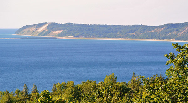
There is no beach access from the dune nor anywhere in the preserve because of the towering bluffs. But there are magnificent views. A sandy trail heads due north and at Mile 1.8 reaches the 940-foot crown of Old Baldy. From this lofty “peak” you can spot the Frankfort Lighthouse along the Lake Michigan coastline and a portion of Lower Herring Lake, a panoramic view that rivals anything to the north in Sleeping Bear Dunes. Along the way a second trail heads west through a distinctive notch to an overlook of the lake and the perched dunes stretching to the south.

The return to the trailhead begins by backtracking and descending the cable steps to post No. 5 and then continuing due south to post No. 6, reached at Mile 2.2.  Heading south and west at the four-way junction are two of the old gravel roads put in for a subdivision development that failed. Lucky us. Head west (right) on one of the former roads and with a few hundred yards it will swing south to follow the edge of the bluff. At Mile 2.7 you reach post No. 7, marking a short spur to a break in the forest and another spectacular viewing area. This one features two decks and "rocking benches" that allow you to take a break and soak up the Lake Michigan horizon.

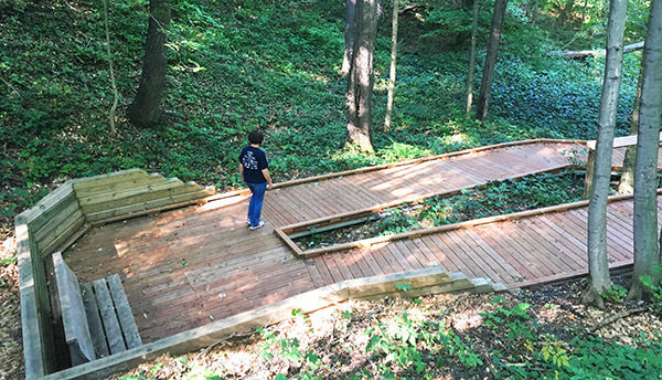
From the viewing area back to the trailhead is the 0.4-mile Overlook Trail, an universally accessible trail with an amazing series of boardwalk switchbacks that allow for an easy descent for anybody.

In the final leg of the loop the trail swings east, reaches post No. 8 at Mile 3 and then pops out at the entrance road to the trail head.

Facilities

At the trailhead there is parking and an information kiosk but no toilets or drinking water.

Hours & Fees

There is are no vehicle entry fees at Arcadia Dunes. The nature preserve is open year-round.

Directions

Baldy Trailhead is posted along M-22, 8 miles south of Elberta or 2.7 miles north of Arcadia. If heading south, the trailhead entrance is on the west side of the state highway, 0.7 miles south of Joyfield Road.

Information

Contact the Grand Traverse Regional Land Conservancy at (231) 929-7911 or online at www.gtrlc.org. For lodging or travel information contact Traverse City Tourism (800-872-8377; www.traversecity.com).


Geo-referenced maps from MichiganTrailMaps.com range from $1.99 to $2.99 each.

Download the Avenza app from the App Store or Google Play

App Store Google Play

Michigan TrailMaps.com Michigan's Premier Trail Resource Contact

Trail Mix News

by travel and outdoor writer Jim DuFresne!

Sign Up
Enews Signup
Find a Trail

Find Trails & Maps

Search for Trail
Search by Location
Search by