11000 Camp Pet-O-Se-Ga
Alanson, MI 49706 US
Phone: (231) 347-6536
Region: Northwest
Website
More Info
Leeward Drive
Alanson, MI 49770 US
Phone: (231) 347-0991
Region: Northwest
Website
More Info
Corner of Valley Street and Smalley Street
Alden, MI 49770 US
Phone: (231) 331-4643
Region: Heartland
More Info
M-32
Gaylord, MI US
Phone: (989) 732-3541
Region: Northwest
More Info
3582 State Park Dr.
Bay City, MI 48706-1356 US
Phone: (989) 667-0717
Region: Lake Huron (Includes the Thumb)
More Info
3582 State Park Drive
Bay City, MI 48706 US
Phone: (989) 667-0717
Region: Lake Huron (Includes the Thumb)
More Info
M-22
Frankfort, MI US
Phone: (231) 929-7911
Region: Lake Michigan
Website
More Info
Goose Rd
Honor, MI US
Phone: (231) 922-5280
Region: Northwest
More Info
1129 Wilson Street
Boyne City, MI 49712 US
Phone: (231) 582-6597
Region: Northwest
Website
More Info
1129 Wilson Street
Boyne City, MI 49712 US
Phone: (231) 582-6597
Region: Northwest
Website
More Info
2280 Boyne City Road
Boyne City, MI 49712 US
Phone: (231) 582-7523
Region: Northwest
More Info
6093 E. M-115
Cadillac, MI 49601 US
Phone: (231) 775-7911
Region: Lake Michigan
More Info
37205 Mouillee Rd
Rockwood, MI 48173 US
Phone: (734) 379-9692
Region: Southeast
More Info
37205 Mouillee Rd
Rockwood, MI 48173 US
Phone: (734) 379-9692
Region: Southeast
More Info
37205 Mouillee Rd
Rockwood, MI 48173 US
Phone: (734) 379-9692
Region: Southeast
More Info
3582 State Park Drive
Bay City, MI 48706 US
Phone: (989) 667-0717
Region: Lake Huron (Includes the Thumb)
More Info
12032 Red Arrow Highway
Sawyer, MI 49125 US
Phone: (269) 426-4013
Region: Lake Michigan
More Info
12032 Red Arrow Highway
Sawyer, MI 49125 US
Phone: (269) 426-4013
Region: Lake Michigan
More Info
32911 Willow Road
New Boston, MI 48164 US
Phone: (734) 782-3956
Region: Southeast
Website
More Info
M-22
Frankfort, MI US
Phone: (231) 929-7911
Region: Western Upper Peninsula
Website
More Info
M-22 & Saint Pierre Road
Arcadia, MI US
Phone: (231) 929-7911
Region: Northwest
Website
More Info
20145 Beck Road
Northville, MI 48167 US
Phone: (248) 349-8390
Region: Southeast
Website
More Info
M-22
Frankfort, MI US
Phone: (231) 326-5134
Region: Northwest
Website
More Info
20145 Beck Road
Northville, MI 48167 US
Phone: (248) 349-8390
Region: Southeast
Website
More Info
20145 Beck Road
Northville, MI 48134 US
Phone: (248) 349-8390
Region: Southeast
Website
More Info
Haggerty Rd
Sumpter Township, MI 48111 US
Phone: (734) 654-1223
Region: Southeast
More Info
20379 Marcellus Highway
Decatur, MI 49045 US
Phone: (269) 445-8611
Region: Lake Michigan
Website
More Info
Haggerty Rd
Sumpter Township, MI 48111 US
Phone: (734) 654-1223
Region: Southeast
More Info
4216 Ranger Road
Grayling, MI 49738 US
Phone: (989) 348-7068
Region: Northwest
More Info
8555 Silver Hill Road
Pinckney, MI 48169 US
Phone: (734) 426-4913
Region: Southeast
Website
More Info
8555 Silver Hill Road
Pinckney, MI 48169 US
Phone: (734) 426-4913
Region: Southeast
Website
More Info
8555 Silver Hill Road
Pinckney, MI 48169 US
Phone: (734) 426-4913
Region: Southeast
Website
More Info
4216 Ranger Road
Grayling, MI 49738 US
Phone: (989) 348-7068
Region: Northwest
More Info
8555 Silver Hill Road
Pinckney, MI 48169 US
Phone: (734) 426-4913
Region: Southeast
Website
More Info
4650 Geddes
Ann Arbor, MI 48105 US
Phone: (734) 971-6337
Region: Southeast
Website
More Info
4216 Ranger Road
Grayling, MI 49738 US
Phone: (989) 348-7068
Region: Northwest
More Info
S. Parker Rd
Ann Arbor, MI 48103 US
Phone: (734) 971-6337
Region: Southeast
Website
More Info
4216 Ranger Road
Grayling, MI 49738 US
Phone: (989) 348-7068
Region: Northwest
Website
More Info
8251 Germania Road
Cass City, MI 48726 US
Phone: (989) 856-4411
Region: Lake Huron (Includes the Thumb)
Website
More Info
4216 Ranger Rd
Grayling, MI 49738 US
Phone: (989) 348-7068
Region: Northwest
More Info
6975 Mower Road
Saginaw, MI 48601 US
Phone: (989) 759-1669
Region: Lake Huron (Includes the Thumb)
Website
More Info
M-72
Roscommon, MI US
Phone: (989) 275-5151
Region: Northwest
More Info
Mt McSauba Road
Charlevoix, MI 49720 US
Phone: (231) 347-0991
Region: Northwest
Website
More Info
Tin Lizzy Lane
Saginaw, MI 48722 US
Phone: (989) 759-1669
Region: Lake Huron (Includes the Thumb)
Website
More Info
Strobelbel Rd
Saginaw, MI 48602 US
Phone: (989) 759-1669
Region: Lake Huron (Includes the Thumb)
Website
More Info
3010 Maple St
Saginaw, MI 48602 US
Phone: (989) 759-1669
Region: Lake Huron (Includes the Thumb)
Website
More Info
6975 Mower Road
Saginaw, MI 48601 US
Phone: (989) 759-1669
Region: Lake Huron (Includes the Thumb)
Website
More Info
6685 Sheridan Rd
Saginaw, MI 48601 US
Phone: (989) 790-5280
Region: Lake Huron (Includes the Thumb)
Website
More Info
106 State Park Drive
Roscommon, MI 48653 US
Phone: (989) 821-6374
Region: Heartland
Website
More Info
M-33 and Tomahawk Lake Hwy
Onaway, MI 49765 US
Phone: (989) 732-3541
Region: Lake Huron (Includes the Thumb)
More Info
32911 Willow Road
New Boston, MI 48164 US
Phone: (800) 477-3182
Region: Southeast
Website
More Info
Ocqueoc Falls Road
Rogers City , MI 49779 US
Phone: (989) 732-3541
Region: Lake Huron (Includes the Thumb)
More Info
76th or 84th Ave.
Zeeland, MI 49464 US
Phone: (616) 738-4810
Region: Lake Michigan
Website
More Info
84th Ave
Zeeland, MI 49464 US
Phone: (616) 738-4810
Region: Lake Michigan
Website
More Info
13925 Lakeshore Drive
Grand Haven, MI 49417 US
Phone: (616) 738-4810
Region: Lake Michigan
Website
More Info
Lone Pine Road
Gaylord, MI 49735 US
Phone: (989) 732-3541
Region: Northwest
More Info
Pickerel Lake Road
Vanderbilt, MI 49795 US
Phone: (989) 983-4101
Region: Northwest
More Info
Fairview Ave.
Gaylord, MI US
Phone: (800) 345-8621
Region: Northwest
Website
More Info
Fairview Ave.
Gaylord, MI US
Phone: (800) 345-8621
Region: Northwest
Website
More Info
3435 S. Straits Highway
Indian River, MI 49749 US
Phone: (800) 345-8621
Region: Northwest
Website
More Info
Sturgeon Valley Rd.
Vanderbilt, MI 49795 US
Phone: (989) 983-4101
Region: Northwest
More Info
Sturgeon Valley Rd.
Vanderbilt, MI 49795 US
Phone: (989) 983-4101
Region: Northwest
More Info
Sturgeon Valley Rd.
Vanderbilt, MI 49795 US
Phone: (989) 983-4101
Region: Northwest
More Info
Vienna Corners
Gaylord, MI 49735 US
Phone: (989) 732-3541
Region: Northwest
More Info
239 Commerce Blvd.
Gaylord, MI 49735 US
Phone: (800) 345-8621
Region: Northwest
Website
More Info
239 Commerce Blvd.
Gaylord, MI 49735 US
Phone: (800) 345-8621
Region: Northwest
Website
More Info
239 Commerce Blvd.
Gaylord, MI 49735 US
Phone: (800) 345-8621
Region: Northwest
Website
More Info
9679 State Park Rd
Mears, MI 49436 US
Phone: (231) 873-3083
Region: Lake Michigan
Website
More Info
8100 Grange Hall Road
Holly, MI 48442 US
Phone: (248) 634-8811
Region: Southeast
Website
More Info
8100 Grange Hall Road
Holly, MI 48442 US
Phone: (248) 634-8811
Region: Southeast
Website
More Info
8100 Grange Hall Road
Holly, MI 48442 US
Phone: (248) 634-8811
Region: Southeast
Website
More Info
8100 Grange Hall Road
Holly, MI 48442 US
Phone: (248) 634-8811
Region: Southeast
Website
More Info
5142 E Holly Rd.
Holly, MI 48442 US
Phone: (248) 634-1758
Region: Southeast
Website
More Info
9966 Twin Lakes Road
Vanderbilt, MI 49795 US
Phone: (989) 983-4101
Region: Northwest
More Info
Eaton Road
Springfield Township, MI US
Phone: (248) 846-6558
Region: Southeast
More Info
14390 Fish Lake Road
Holly, MI 48442 US
Phone: (248) 634-7271
Region: Southeast
Website
More Info
14390 Fish Lake Road
Holly, MI 48442 US
Phone: (248) 634-7271
Region: Southeast
Website
More Info
14390 Fish Lake Road
Holly, MI 48442 US
Phone: (248) 634-7271
Region: Southeast
More Info
14390 Fish Lake Road
Holly, MI 48442 US
Phone: (248) 634-7271
Region: Southeast
Website
More Info
10400 Fish Lake Road
Holly, MI 48442 US
Phone: (248) 858-0906
Region: Southeast
Website
More Info
3500 Wixom Road
Commerce Township, MI 48382 US
Phone: (248) 685-2433
Region: Southeast
Website
More Info
3500 Wixom Road
Commerce Township, MI 48382 US
Phone: (248) 685-2433
Region: Southeast
Website
More Info
3500 Wixom Road
Commerce Township, MI 48382 US
Phone: (248) 685-2433
Region: Southeast
Website
More Info
4480 Orion Road
Rochester, MI 48306 US
Phone: (248) 651-9260
Region: Southeast
More Info
2301 W Clarkston Road
Lake Orion, MI 48360 US
Phone: (248) 625-0877
Region: Southeast
Website
More Info
2301 W Clarkston Road
Lake Orion, MI 48360 US
Phone: (248) 625-0877
Region: Southeast
Website
More Info
52221 Pontiac Trail
Wixom, MI 48393 US
Phone: (248) 437-7345
Region: Southeast
Website
More Info
5200 Indian Trail
White Lake, MI 48386 US
Phone: (800) 477-2757
Region: Southeast
Website
More Info
5200 Indian Trail
White Lake, MI 48386 US
Phone: (800) 477-2757
Region: Southeast
Website
More Info
5200 Indian Trail
White Lake, MI 48386 US
Phone: (800) 477-2757
Region: Southeast
Website
More Info
5200 Indian Trail
White Lake, MI 48386 US
Phone: (800) 477-2757
Region: Southeast
Website
More Info
5200 Indian Trail
White Lake, MI 48386 US
Phone: (800) 477-2757
Region: Southeast
Website
More Info
5200 Indian Trail
White Lake, MI 48386 US
Phone: (800) 477-2757
Region: Southeast
Website
More Info
9501 Sashabaw Road
Clarkston, MI 48348 US
Phone: (248) 625-0877
Region: Southeast
Website
More Info
9501 Sashabaw Road
Clarkston, MI 48348 US
Phone: (248) 625-0877
Region: Southeast
Website
More Info
9501 Sashabaw Road
Clarkston, MI 48348 US
Phone: (248) 625-0877
Region: Southeast
Website
More Info
9501 Sashabaw Road
Clarkston, MI 48348 US
Phone: (248) 625-0877
Region: Southeast
Website
More Info
5200 Highland Road
White Lake, MI 48383 US
Phone: (248) 889-3750
Region: Southeast
Website
More Info
5200 Highland Road
White Lake, MI 48383 US
Phone: (248) 889-3750
Region: Southeast
Website
More Info
5200 Highland Road
White Lake, MI 48383 US
Phone: (248) 889-3750
Region: Southeast
Website
More Info
5200 Highland Road
White Lake, MI 48383 US
Phone: (248) 889-3750
Region: Southeast
Website
More Info
1330 E. Greenshield Road
Lake Orion, MI 48360 US
Phone: (248) 693-6767
Region: Southeast
Website
More Info
1330 E. Greenshield Road
Lake Orion, MI 48360 US
Phone: (248) 693-6767
Region: Southeast
Website
More Info
1330 E. Greenshield Road
Lake Orion, MI 48360 US
Phone: (248) 693-6767
Region: Southeast
Website
More Info
4794 6 Mile Road
White Cloud, MI 49349 US
Phone: (231) 745-4631
Region: Heartland
Website
More Info
Jefferson Rd.
Croton, MI US
Phone: (877) 500-2570
Region: Heartland
More Info
Buttles Road
Lewiston, MI 49756 US
Phone: (989) 732-3541
Region: Lake Huron (Includes the Thumb)
More Info
2800 State Park Road
Monroe, MI 48162 US
Phone: (734) 289-2715
Region: Southeast
Website
More Info
400 S. Badour Rd.
Midland, MI 48640 US
Phone: (989) 631-0830
Region: Lake Huron (Includes the Thumb)
Website
More Info
8800 W. M-116
Ludington, MI 49431 US
Phone: (231) 843-2423
Region: Lake Michigan
Website
More Info
8800 W. M-116
Ludington, MI 49431 US
Phone: (231) 843-2423
Region: Lake Michigan
Website
More Info
8800 W. M-116
Ludington, MI 49431 US
Phone: (231) 843-2423
Region: Lake Michigan
Website
More Info
8800 W. M-116
Ludington, MI 49431 US
Phone: (231) 843-2423
Region: Lake Michigan
Website
More Info
8800 W. M-116
Ludington, MI 49431 US
Phone: (231) 843-2423
Region: Lake Michigan
Website
More Info
9922 Front Street
Empire, MI 49630 US
Phone: (231) 326-5134
Region: Northwest
Website
More Info
Stocking Road
Glen Arbor, MI US
Phone: (231) 326-5134
Region: Northwest
Website
More Info
Forest Road 5993
Cadillac, MI 49601 US
Phone: (231) 723-2211
Region: Lake Michigan
Website
More Info
6360 Chilson Road
Howell, MI 48843 US
Phone: (810) 229-6566
Region: Southeast
Website
More Info
M-109
Empire, MI US
Phone: (231) 326-5134
Region: Northwest
Website
More Info
M-209
Glen Arbor, MI US
Phone: (231) 326-5134
Region: Northwest
Website
More Info
6360 Chilson Road
Howell, MI 48843 US
Phone: (810) 229-6566
Region: Southeast
Website
More Info
6360 Chilson Road
Howell, MI 48843 US
Phone: (810) 229-6566
Region: Southeast
Website
More Info
Deadman’s Hill Road
Alba, MI US
Phone: (989) 732-3541
Region: Northwest
More Info
Deadman’s Hill Road
Mancelona, MI US
Phone: (800) 345-8621
Region: Northwest
More Info
Wilco Road
Empire, MI US
Phone: (231) 326-5134
Region: Northwest
Website
More Info
Lake Michigan Road
Glen Arbor, MI US
Phone: (231) 326-5134
Region: Northwest
Website
More Info
15310 N. Lighthouse Point Road
Northport, MI 49670 US
Phone: (231) 386-5422
Region: Northwest
More Info
Densmore Road
Northport, MI US
Phone: (231) 386-5422
Region: Northwest
More Info
207 W. River Street
Leland, MI 49654 US
Phone: (231) 326-5134
Region: Northwest
Website
More Info
207 W. River Street
Leland, MI 49654 US
Phone: (231) 326-5134
Region: Northwest
Website
More Info
Basch Road
Glen Arbor, MI US
Phone: (231) 326-5134
Region: Northwest
Website
More Info
Pierce Stocking Scenic Drive
Empire, MI US
Phone: (231) 326-5134
Region: Northwest
Website
More Info
Welch Road
Empire, MI US
Phone: (231) 326-5134
Region: Northwest
Website
More Info
M-32
Gaylord, MI US
Phone: (989) 732-3541
Region: Northwest
More Info
4971 County Road 612
Grayling, MI 49733 US
Phone: (989) 348-5989
Region: Northwest
Website
More Info
4971 County Road 612
Grayling, MI 49733 US
Phone: (989) 348-5989
Region: Northwest
Website
More Info
4971 County Road 612
Grayling, MI 49733 US
Phone: (989) 348-5989
Region: Northwest
Website
More Info
Bell's Bay Road
Charlevoix, MI 49720 US
Phone: (231) 547-6641
Region: Northwest
More Info
3871 Hurd Rd.
Metamora, MI 48455 US
Phone: (810) 797-4439
Region: Southeast
More Info
State Road
Luther, MI US
Phone: (231) 775-9727
Region: Heartland
More Info
7 Mile Road
Baldwin, MI US
Phone: (231) 775-9727
Region: Heartland
More Info
County Road 597
Kalkaska, MI US
Phone: (231) 258-2711
Region: Northwest
More Info
Yuba Road
Elk Rapids, MI US
Phone: (231) 938-1350
Region: Northwest
Website
More Info
4167 M-137
Interlochen, MI 49643 US
Phone: (231) 276-9511
Region: Northwest
More Info
US-27
Ithaca, MI US
Phone: (517) 641-4903
Region: Heartland
More Info
Wildwood Road
Interlochen, MI US
Phone: (231) 922-5280
Region: Northwest
More Info
Meredith Grade Road
Meredith, MI US
Phone: (989) 426-9205
Region: Lake Huron (Includes the Thumb)
More Info
2142 N. Genesee Road
Flint, MI 48509 US
Phone: (810) 789-8567
Region: Southeast
Website
More Info
2142 N. Genesee Road
Flint, MI 48509 US
Phone: (810) 789-8567
Region: Southeast
Website
More Info
686 Tawas Beach Road
East Tawas, MI 48730 US
Phone: (989) 362-5041
Region: Lake Huron (Includes the Thumb)
More Info
6260 East Lake Drive
Haslett, MI 48840 US
Phone: (517) 676-2233
Region: Heartland
Website
More Info
6260 East Lake Drive
Haslett, MI 48840 US
Phone: (517) 676-2233
Region: Heartland
Website
More Info
6260 East Lake Drive
Haslett, MI 48840 US
Phone: (517) 676-2233
Region: Heartland
Website
More Info
Loosemore Road
Port Austin, MI 48467 US
15675 Headlands Rd
Mackinaw City, MI 49701 US
Phone: (231) 348-1704
Region: Northwest
Website
More Info
Krause Road
Petoskey, MI US
Phone: (231) 347-0991
Region: Northwest
Website
More Info
903 Wilderness Park Drive
Mackinaw City, MI 49718 US
Phone: (231) 436-5381
Region: Northwest
More Info
903 Wilderness Park Drive
Mackinaw City, MI 49718 US
Phone: (231) 436-5381
Region: Northwest
More Info
903 Wilderness Park Drive
Mackinaw City, MI 49718 US
Phone: (231) 436-5381
Region: Northwest
More Info
903 Wilderness Park Drive
Mackinaw City, MI 49718 US
Phone: (231) 436-5381
Region: Northwest
More Info
903 Wilderness Park Drive
Mackinaw City, MI 49718 US
Phone: (231) 436-5381
Region: Northwest
More Info
2475 M-119 Hwy
Petoskey, MI 49770 US
Phone: (231) 347-2311
Region: Northwest
More Info
2475 M-119 Hwy
Petoskey, MI 49770 US
Phone: (231) 347-2311
Region: Northwest
More Info
2475 M-119 Hwy
Petoskey, MI 49770 US
Phone: (231) 347-2311
Region: Northwest
More Info
2475 M-119 Hwy
Petoskey, MI 49770 US
Phone: (231) 347-2311
Region: Northwest
More Info
8258 South Ayr Road
Alanson, MI 49706 US
Phone: (231) 348-0998
Region: Northwest
Website
More Info
Maxwell Road
Petoskey, MI US
Phone: (231) 347-0991
Region: Northwest
Website
More Info
Robinson Road
Harbor Springs, MI US
Phone: (231) 347-0991
Region: Northwest
Website
More Info
600 Birchwood Drive
Harbor Springs, MI 49740 US
Phone: (231) 348-2755
Region: Northwest
More Info
Standish Avenue
Petoskey, MI 49770 US
Phone: (231) 347-2500
Region: Northwest
Website
More Info
l3991 Tallman Road
Grand Ledge, MI 48837 US
Phone: (517) 627-7351
Region: Heartland
Website
More Info
13991 Tallman Road
Grand Ledge, MI 48837 US
Phone: (517) 627-7351
Region: Heartland
Website
More Info
245 S. Williams Street
Bellevue, MI 49021 US
Phone: (517) 627-7351
Region: Heartland
Website
More Info
133 Fitzgerald Park Drive
Grand Ledge, MI 48837 US
Phone: (517) 627-7351
Region: Heartland
Website
More Info
133 Fitzgerald Park Drive
Grand Ledge, MI 48837 US
Phone: (517) 627-7351
Region: Heartland
Website
More Info
2280 Boyne City Road
Boyne City, MI 49712 US
Phone: (231) 582-7523
Region: Northwest
More Info
2280 Boyne City Road
Boyne City, MI 49712 US
Phone: (231) 582-7523
Region: Northwest
More Info
2280 Boyne City Road
Boyne City, MI 49712 US
Phone: (231) 582-7523
Region: Northwest
More Info
Old Horton Bay Road
Boyne City, MI 49712 US
Phone: (231) 347-0991
Region: Northwest
Website
More Info
US-31
Charlevoix, MI US
Phone: (231) 347-0991
Region: Northwest
Website
More Info
Chandler Road
Boyne Falls, MI US
Phone: (989) 732-3541
Region: Northwest
More Info
Maple Grove Road
Charlevoix, MI US
Phone: (231) 347-0991
Region: Northwest
Website
More Info
1129 Wilson Street
Boyne City, MI 49712 US
Phone: (231) 582-6597
Region: Northwest
Website
More Info
32911 Willow Road
New Boston, MI 48164 US
Phone: (800) 477-3182
Region: Southeast
Website
More Info
Forest Highway 9300
Marenisco, MI US
Phone: (906) 358-4724
Region: Western Upper Peninsula
More Info
800 East Lakeshore Drive
Houghton, MI 49931 US
Phone: (906) 482-0984
Region: Western Upper Peninsula
Website
More Info
800 East Lakeshore Drive
Houghton, MI 49931 US
Phone: (906) 482-0984
Region: Western Upper Peninsula
Website
More Info
800 East Lakeshore Drive
Houghton, MI 49931 US
Phone: (906) 482-0984
Region: Western Upper Peninsula
Website
More Info
800 East Lakeshore Drive
Houghton, MI 49931 US
Phone: (906) 482-0984
Region: Western Upper Peninsula
Website
More Info
800 East Lakeshore Drive
Houghton, MI 49931 US
Phone: (906) 482-0984
Region: Western Upper Peninsula
Website
More Info
800 East Lakeshore Drive
Houghton, MI 49931 US
Phone: (906) 482-0984
Region: Western Upper Peninsula
Website
More Info
800 East Lakeshore Drive
Houghton, MI 49931 US
Phone: (906) 482-0984
Region: Western Upper Peninsula
Website
More Info
800 East Lakeshore Drive
Houghton, MI 49931 US
Phone: (906) 482-0984
Region: Western Upper Peninsula
Website
More Info
M-109
Glen Arbor, MI US
Phone: (231) 326-5134
Region: Northwest
Website
More Info
6585 Lake Harbor Rd
Muskegon, MI 49441 US
Phone: (231) 798-3711
Region: Lake Michigan
More Info
6585 Lake Harbor Rd
Muskegon, MI 49441 US
Phone: (231) 798-3711
Region: Lake Michigan
More Info
Thornton Road
Stevensville, MI 49127 US
Phone: (269) 426-4013
Region: Lake Michigan
More Info
239 Commerce Blvd.
Gaylord, MI 49735 US
Phone: (800) 345-8621
Region: Northwest
More Info
Wildwood Road
Indian River, MI US
Phone: (989) 732-3541
Region: Northwest
More Info
Boyne City-Charlevoix Road
Boyne City, MI US
Phone: (231) 347-0991
Region: Northwest
Website
More Info
09223 McSauba Rd
Charlevoix, MI 49720 US
Phone: (231) 547-3267
Region: Northwest
Website
More Info
Sand Hill Trail
Black River, MI US
Phone: (989) 724-5126
Region: Lake Huron (Includes the Thumb)
Website
More Info
17030 Bush Rd.
Chelsea, MI 48118 US
Phone: (734) 475-3170
Region: Heartland
Website
More Info
1775 Port Austin Road
Port Austin, MI 48467 US
Phone: (989) 738-8663
Region: Lake Huron (Includes the Thumb)
More Info
River Road
Oscoda, MI US
Phone: (989) 362-8961
Region: Lake Huron (Includes the Thumb)
Website
More Info
Monument Road
Tawas City, MI US
Phone: (989) 362-2001
Region: Lake Huron (Includes the Thumb)
Website
More Info
850 West Osterhout Rd
Portage, MI US
Phone: (269) 329-4522
Region: Heartland
Website
More Info
2104 S. Briggs Rd
Middleville, MI 49333 US
Phone: (269) 795-9081
Region: Heartland
More Info
Reserve Road
Houghton Lake, MI US
Phone: (989) 275-5151
Region: Heartland
More Info
3351 Mundy Rd
White Lake, MI 49349 US
Phone: (231) 652-9298
Region: Heartland
Website
More Info
Elm Valley Road
Sawyer, MI 49125 US
Phone: (269) 426-4013
Region: Lake Michigan
More Info
138th Avenue
Saugatuck, MI 49453 US
Phone: (269) 637-2788
Region: Lake Michigan
More Info
3560 Memorial Dr.
Muskegon, MI 49445 US
Phone: (231) 744-3480
Region: Lake Michigan
More Info
1687 M-119
Petoskey, MI 49770 US
Phone: (231) 348-8280
Region: Northwest
Website
More Info
Reynolds Road
Lake Ann, MI US
Phone: (231) 922-5280
Region: Northwest
More Info
M-72
Grayling, MI US
Phone: (989) 826-3252
Region: Northwest
More Info
M-37
Traverse City, MI US
Phone: (231) 223-7322
Region: Northwest
Website
More Info
M-23
Rogers City , MI 49779 US
Phone: (989) 734-2543
Region: Lake Huron (Includes the Thumb)
Website
More Info
N8391 Sand Point Rd
Munising, MI 49862 US
Phone: (906) 387-3700
Region: Eastern Upper Peninsula
Website
More Info
1505 Sand Point Rd
Munising, MI 49862 US
Phone: (906) 387-3700
Region: Eastern Upper Peninsula
Website
More Info
4490 Beach Rd.
Cheboygan, MI 49721 US
Phone: (231) 627-2811
Region: Lake Huron (Includes the Thumb)
Website
More Info
M-22
Empire, MI US
Phone: (231) 326-5134
Region: Northwest
Website
More Info
Lake Michigan Road
Manistee, MI US
Phone: (231) 723-2211
Region: Lake Michigan
Website
More Info
Thoreson Road
Glen Arbor, MI US
Phone: (231) 326-5134
Region: Northwest
Website
More Info
Traverse Bay Road
Torch Lake, MI US
Phone: (231) 599-2036
Region: Northwest
Website
More Info
Old Dixie Highway
Atwood, MI US
Phone: (231) 533-6265
Region: Northwest
Website
More Info
1031 W. Dexter Trail
Mason, MI 48854 US
Phone: (517) 676-2290
Region: Heartland
Website
More Info
Sturgeon Valley Road
Vanderbilt, MI 49795 US
Phone: (989) 983-4101
Region: Northwest
More Info
16th Avenue
Sault Ste. Marie, MI 49799 US
Phone: (906) 635-5281
Region: Eastern Upper Peninsula
Website
More Info
8765 Hammel Rd.
Brighton, MI 48116 US
Phone: (734) 426-8211
Region: Southeast
Website
More Info
Guernsey Lake Road
Traverse City, MI US
Phone: (231) 922-5280
Region: Northwest
More Info
Broomhead Road
Traverse City, MI US
Phone: (231) 922-5280
Region: Northwest
More Info
M-37
Traverse City, MI US
Phone: (231) 223-7322
Region: Northwest
Website
More Info
6500 Alden Hyw
Bellaire, MI 49615 US
Phone: (231) 533-8314
Region: Northwest
Website
More Info
Ranch Rudolf Road
Traverse City, MI US
Phone: (231) 922-5280
Region: Northwest
More Info
1785 N. East Silver Lake Rd
Traverse City, MI 49684 US
Phone: (231) 941-1620
Region: Northwest
Website
More Info
Old US-131 & US-131
Fife Lake, MI US
Phone: (866) 445-3628
Region: Northwest
Website
More Info
Mayfield and Wadsworth Roads
Mayfield, MI US
Phone: (231) 941-0960
Region: Northwest
Website
More Info
1450 Cass Rd.
Traverse City, MI 49685 US
Phone: (231) 941-0960
Region: Northwest
Website
More Info
Beitner Road
Traverse City, MI US
Phone: (231) 941-0960
Region: Northwest
Website
More Info
Pyatt Road
Traverse City, MI US
Phone: (231) 929-7911
Region: Northwest
Website
More Info
M-22
Leland, MI US
Phone: (231) 256-9669
Region: Northwest
Website
More Info
Ranch Rudolf Road
Traverse City, MI US
Phone: (231) 941-0960
Region: Northwest
Website
More Info
M-22
Leland, MI US
Phone: (231) 256-9665
Region: Northwest
Website
More Info
M-22
Leland, MI US
Phone: (231) 256-9665
Region: Northwest
Website
More Info
Kehl Lake Road
Northport, MI US
Phone: (231) 256-9665
Region: Northwest
Website
More Info
Green Point Road
Frankfort, MI US
Phone: (231) 929-7911
Region: Northwest
Website
More Info
Pierce Stocking Drive & M-109
Empire, MI US
Phone: (231) 326-5134
Region: Northwest
Website
More Info
Stover Road
Bellaire, MI US
Phone: (231) 533-8363
Region: Northwest
Website
More Info
Swamp Road
Elberta, MI US
Phone: (231) 929-7911
Region: Northwest
Website
More Info
Esch Road
Empire, MI US
Phone: (231) 326-5134
Region: Northwest
Website
More Info
M-22
Arcadia, MI US
Phone: (231) 929-7911
Region: Northwest
Website
More Info
M-22 & Norman Road
Arcadia, MI US
Phone: (231) 929-7911
Region: Northwest
Website
More Info
M-22
Elberta, MI US
Phone: (231) 929-7911
Region: Northwest
Website
More Info
Herron Road (County Road 604)
Elberta, MI US
Phone: (231) 929-7911
Region: Northwest
Website
More Info
10th Street & Main Street
Frankfort, MI US
Phone: (800) 882-5801
Region: Northwest
Website
More Info
Mollineaux Road
Elberta, MI US
Phone: (231) 929-7911
Region: Northwest
Website
More Info
M-22
Elberta, MI US
Phone: (231) 929-7911
Region: Northwest
Website
More Info
Boon and Seeley Roads
Cadillac, MI US
Phone: (231) 775-9727
Region: Northwest
Website
More Info
Forest Haven Drive & M-22
Glen Arbor, MI US
Phone: (231) 326-5134
Region: Northwest
Website
More Info
Cherry Bend Road
Traverse City, MI US
Phone: (231) 941-4300
Region: Northwest
Website
More Info
M-22
Empire, MI US
Phone: (231) 256-9665
Region: Northwest
Website
More Info
County Road 629 and Cathead Bay Drive
Northport, MI US
Phone: (231) 256-9665
Region: Northwest
Website
More Info
Cherry Bend Road (County Road 633)
Traverse City, MI US
Phone: (231) 256-9665
Region: Northwest
Website
More Info
Point Betsie Road
Frankfort, MI US
Phone: (517) 316-0300
Region: Northwest
Website
More Info
M-22
Leland, MI US
Phone: (231) 256-9665
Region: Northwest
Website
More Info
Lime Lake Road
Leland, MI US
Phone: (231) 256-9669
Region: Northwest
Website
More Info
1687 M-119
Petoskey, MI 49770 US
Phone: (231) 348-8280
Region: Northwest
Website
More Info
M-119
Petoskey, MI US
Phone: (231) 348-8280
Region: Northwest
Website
More Info
Wheeler Road
Glen Arbor, MI US
Phone: (231) 256-9665
Region: Northwest
Website
More Info
534 W. Grand River Ave
Okemos, MI US
Phone: (517) 853-4608
Region: Heartland
Website
More Info
Frost Street
Dowagiac, MI US
Phone: (517) 655-5655
Region: Lake Michigan
Website
More Info
M-97 & Sunset Drive
Roscommon, MI US
Phone: (989) 275-5151
Region: Northwest
More Info
Industrial Park Drive
Grayling, MI 49738 US
Phone: (800) 937-8837
Region: Northwest
Website
More Info
33303 Headquarters Rd
Ontonagon, MI 49953 US
Phone: (906) 885-5275
Region: Western Upper Peninsula
More Info
County Road F-32
Harrisville, MI US
Phone: (989) 362-8961
Region: Lake Huron (Includes the Thumb)
Website
More Info
33303 Headquarters Rd
Ontonagon, MI 49953 US
Phone: (906) 885-5275
Region: Western Upper Peninsula
More Info
33303 Headquarters Rd
Ontonagon, MI 49953 US
Phone: (906) 885-5275
Region: Western Upper Peninsula
More Info
County Road 519
Wakefield, MI US
Phone: (906) 885-5275
Region: Western Upper Peninsula
More Info
M-72
Mio, MI US
Phone: (989) 826-3252
Region: Lake Huron (Includes the Thumb)
Website
More Info
33303 Headquarters Rd
Ontonagon, MI 49953 US
Phone: (906) 885-5275
Region: Western Upper Peninsula
Website
More Info
Cauchy Road
Mio, MI US
Phone: (989) 826-3252
Region: Lake Huron (Includes the Thumb)
More Info
South Boundary Road
Ontonagon, MI US
Phone: (906) 885-5275
Region: Western Upper Peninsula
More Info
Summit Peak Road
Ontonagon, MI US
Phone: (906) 885-5275
Region: Western Upper Peninsula
More Info
M-72
Curran, MI US
Phone: (989) 739-0728
Region: Lake Huron (Includes the Thumb)
More Info
Summit Peak Road
Ontonagon, MI US
Phone: (906) 885-5275
Region: Western Upper Peninsula
More Info
South Boundary Road
Wakefield, MI US
Phone: (906) 885-5275
Region: Western Upper Peninsula
More Info
33303 Headquarters Rd
Ontonagon, MI US
Phone: (906) 885-5275
Region: Western Upper Peninsula
More Info
South Boundary Road
Ontonagon, MI US
Phone: (906) 885-5275
Region: Western Upper Peninsula
More Info
South Boundary Road
Ontonagon, MI US
Phone: (906) 885-5275
Region: Western Upper Peninsula
More Info
M-107
Ontonagon, MI US
Phone: (906) 885-5275
Region: Western Upper Peninsula
More Info
M-107
Ontonagon, MI US
Phone: (906) 885-5275
Region: Western Upper Peninsula
More Info
Chapel Rd
Shingleton, MI 49884 US
Region: Eastern Upper Peninsula
More Info
9791 N Lakeshore Dr
MI 49460 US
Region: Lake Michigan
More Info
Eagle Harbor Shortcut Road
Eagle Harbor, MI US
Region: Western Upper Peninsula
More Info
North Union Street
Manchester, MI 48158 US
Region: Southeast
More Info
M-72
Traverse City, MI US
Region: Northwest
More Info
3799 Bald Mountain Rd.
Auburn Hills, MI 48326 US
Region: Southeast
More Info
800 East Lakeshore Drive
Houghton, MI 49931 US
Region: Western Upper Peninsula
More Info
Riggsville Road
Pellston, MI 49769 US
Region: Northwest
More Info
North Leroy Road
Fenton, MI 48430 US
Region: Southeast
More Info
800 East Lakeshore Drive
Houghton, MI 49931 US
Region: Western Upper Peninsula
More Info
800 East Lakeshore Drive
Houghton, MI 49931 US
Region: Western Upper Peninsula
More Info
800 East Lakeshore Drive
Houghton, MI 49931 US
Region: Western Upper Peninsula
More Info
800 East Lakeshore Drive
Houghton, MI 49931 US
Region: Western Upper Peninsula
More Info
North Dixboro Road
Ann Arbor, MI 48105 US
Region: Southeast
More Info
800 East Lakeshore Drive
Houghton, MI 49931 US
Region: Western Upper Peninsula
More Info
800 East Lakeshore Drive
Houghton, MI 49931 US
Region: Western Upper Peninsula
More Info
800 East Lakeshore Drive
Houghton, MI 49931 US
Region: Western Upper Peninsula
More Info
800 East Lakeshore Drive
Houghton, MI 49931 US
Region: Western Upper Peninsula
More Info
800 East Lakeshore Drive
Houghton, MI 49931 US
Region: Western Upper Peninsula
More Info
800 East Lakeshore Drive
Houghton, MI 49931 US
Region: Western Upper Peninsula
More Info
800 East Lakeshore Drive
Houghton, MI 49931 US
Region: Western Upper Peninsula
More Info
800 East Lakeshore Drive
Houghton, MI 49931 US
Region: Western Upper Peninsula
More Info
33303 Headquarters Rd
Ontonagon, MI 49953 US
Region: Western Upper Peninsula
More Info
33303 Headquarters Rd
Ontonagon, MI 49953 US
Region: Western Upper Peninsula
More Info
33303 Headquarters Rd
Ontonagon, MI 49953 US
Region: Western Upper Peninsula
More Info
5020 116th Avenue
Allegan, MI 49010 US
Region: Lake Michigan
More Info
Big Knob Rd
Nawbinway, MI US
Region: Eastern Upper Peninsula
More Info
4590 118th Avenue
Allegan, MI 49010 US
Region: Lake Michigan
More Info
4590 118th Avenue
Allegan, MI 49010 US
Region: Lake Michigan
More Info
4590 118th Ave
Allegan, MI 49010 US
Region: Lake Michigan
More Info
6301 Kensington Rd
Brighton, MI 48116 US
Region: Southeast
More Info
800 East Lakeshore Drive
Houghton, MI 49931 US
Region: Western Upper Peninsula
More Info
800 East Lakeshore Drive
Houghton, MI 49931 US
Region: Western Upper Peninsula
More Info
800 East Lakeshore Drive
Houghton, MI 49931 US
Region: Western Upper Peninsula
More Info
800 East Lakeshore Drive
Houghton, MI 49931 US
Region: Western Upper Peninsula
More Info
800 East Lakeshore Drive
Houghton, MI 49931 US
Region: Western Upper Peninsula
More Info
800 East Lakeshore Drive
Houghton, MI 49931 US
Region: Western Upper Peninsula
More Info
800 East Lakeshore Drive
Houghton, MI 49931 US
Region: Western Upper Peninsula
More Info
3749 Whitmarsh Road
Vanderbilt, MI 49795 US
Region: Northwest
More Info
2043 Gingell Rd.
Johannesburg, MI 49751 US
Region: Northwest
More Info
5200 Indian Trail
White Lake, MI 48386 US
Region: Southeast
More Info
800 East Lakeshore Drive
Houghton, MI 49931 US
Region: Western Upper Peninsula
More Info
800 East Lakeshore Drive
Houghton, MI 49931 US
Region: Western Upper Peninsula
More Info
Grand Lake Road
Alpena, MI US
Region: Lake Huron (Includes the Thumb)
More Info
800 East Lakeshore Drive
Houghton, MI 49931 US
Region: Western Upper Peninsula
More Info
Baatz and Fritz Rds
Glen Arbor, MI US
Region: Northwest
More Info
Lutz Rd
MI 48451 US
Region: Southeast
More Info
Norconk Road
Empire, MI US
Region: Northwest
More Info
Loosemore Road
Port Austin, MI 48467 US
Region: Lake Huron (Includes the Thumb)
More Info
Wheeler Road
Glen Arbor, MI US
Region: Northwest
More Info
Wheeler Road
Glen Arbor, MI US
Region: Northwest
More Info
St. Pierre Road
Arcadia, MI US
Region: Northwest
More Info
Herkelrath Road
Onekama, MI US
Region: Northwest
More Info
M-109
Empire, MI US
Region: Northwest
More Info
Christmas Cove Road
Northport, MI US
Region: Northwest
More Info
County Road 513
Rapid City, MI US
Region: Eastern Upper Peninsula
More Info
4785 II Road
Garden, MI 49835 US
Region: Eastern Upper Peninsula
More Info
M-77 North
MI US
Region: Eastern Upper Peninsula
More Info
11511 N. Higgins Lake Drive
Roscommon, MI 48653 US
Region: Northwest
More Info
1001 Huron St.
Ypsilanti, MI 48197 US
Region: Southeast
More Info
Warning Road
MI 49648 US
Region: Northwest
More Info
9435 N. Cut Rd.
Roscommon, MI 48653 US
Region: Heartland
More Info
9966 Twin Lakes Road
Vanderbilt, MI 49795 US
Phone: (989) 983-4101
Region: Northwest
More Info
Osmun and Clark Bridge Road
Vanderbilt, MI 49795 US
Region: Northwest
More Info
Burma Road
Copper Harbor, MI 49918 US
Region: Western Upper Peninsula
More Info
Traverse City, MI 49686 US
Region: Northwest
More Info
Deadstream Rd.
Honor, MI 49640 US
Region: Northwest
More Info
List of Trails
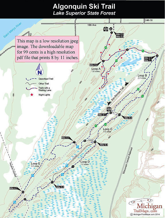
Algonquin Cross Country Ski Trail

Allegan SGA: Ely Lake Trails
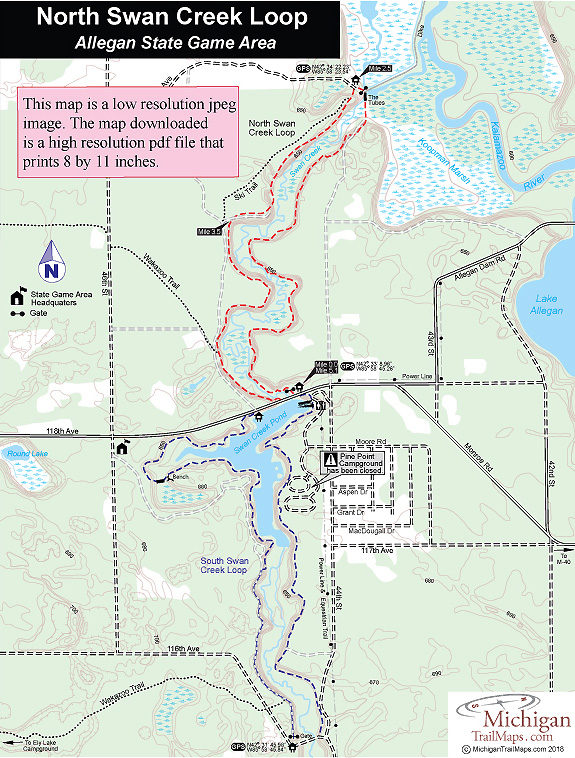
Allegan SGA: North Swan Creek Loop

Allegan SGA: South Swan Creek Loop
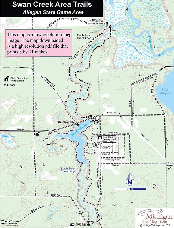
Allegan State Game Area
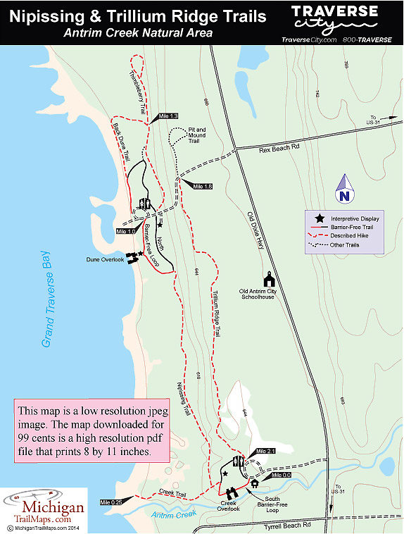
Antrim Creek Natural Area

Arcadia Dunes: Abby's Woods
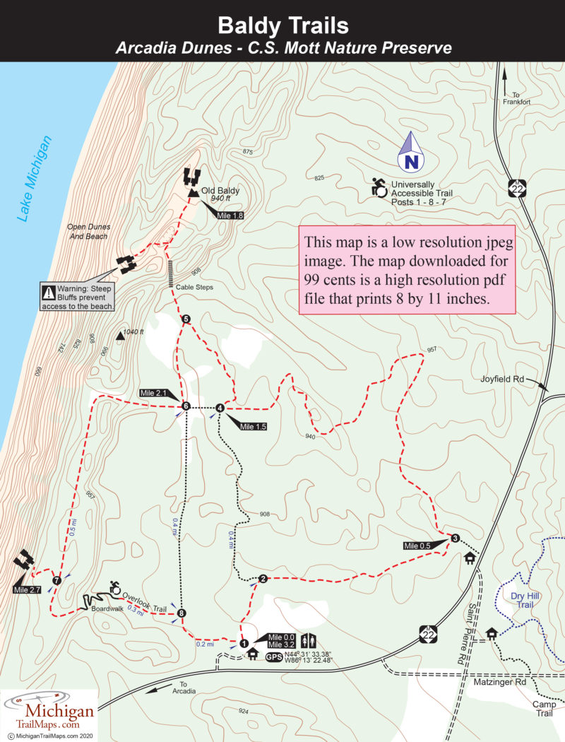
Arcadia Dunes: Baldy Trails

Arcadia Dunes: C.S. Mott Nature Preserve
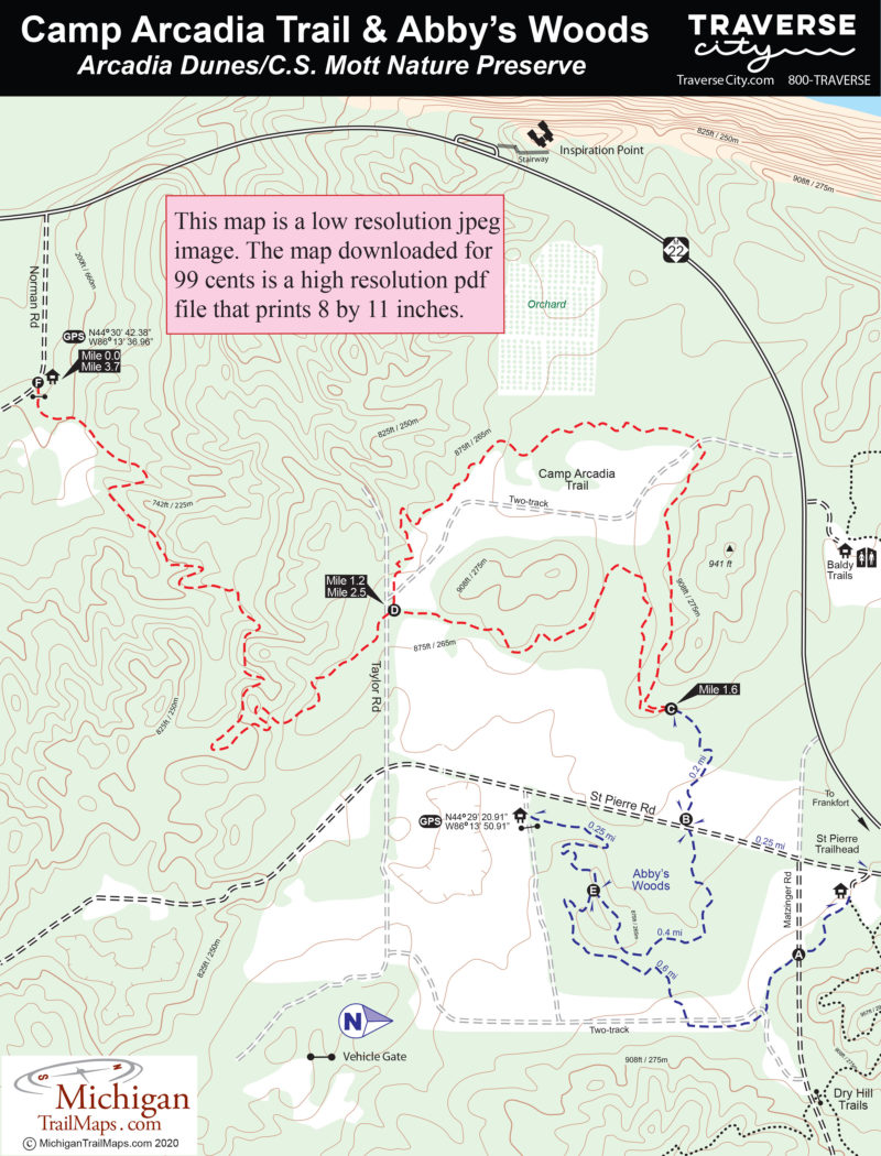
Arcadia Dunes: Camp Trails
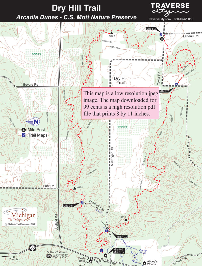
Arcadia Dunes: Dry Hill Trails
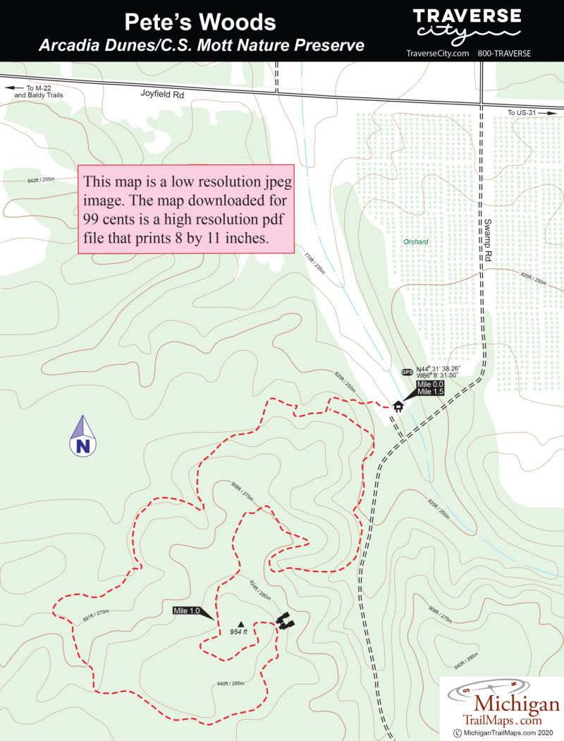
Arcadia Dunes: Pete's Woods

Arcadia Marsh Nature Preserve
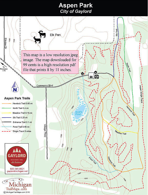
Aspen Park
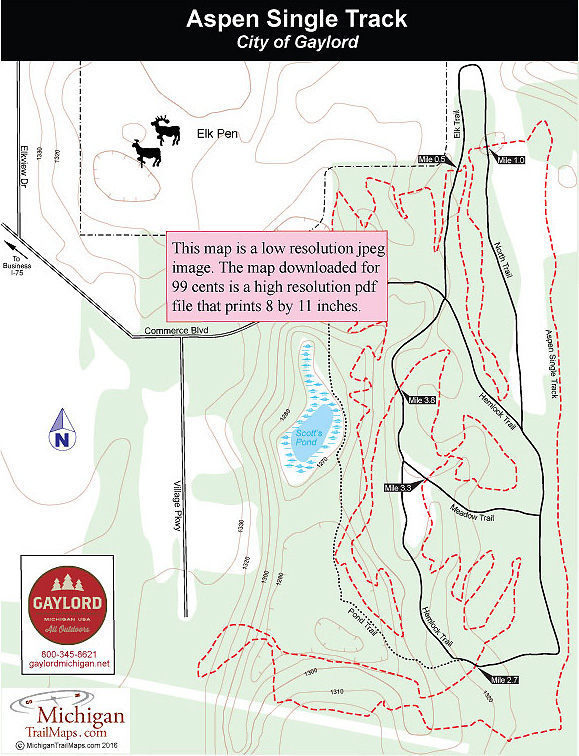
Aspen Park: Aspen Single Track

Aspen Park: Paved Trails
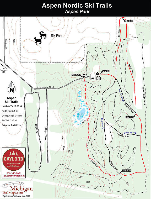
Aspen Park: Ski Trails

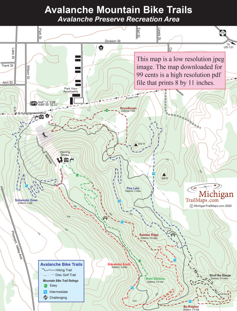
Avalanche Preserve Recreation Area
Avalanche Preserve: Hiking Trail