
Buttles Road Pathway
Buy the $.99 downloadable map!
(This map is not geo-referenced)Trail Details


Originally set up as a cross country ski trail, Buttles Road Pathway in Mackinaw State Forest now also attracts mountain bikers as well as an occasional hiker interested in the sink hole terrain. But the pathway is still best enjoyed in the winter on skis or snowshoes as a layer of snow makes the clearcuts and old gas fields scattered in the area much more tolerable.
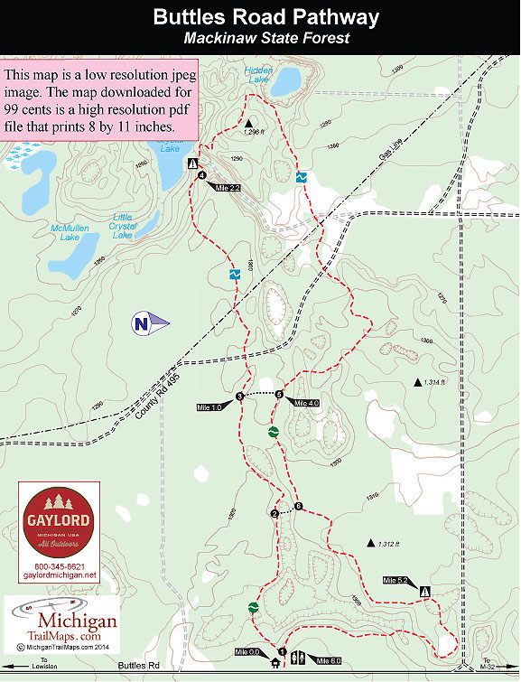
Buttles Road is located in the western edge of Montmorency County, only a 30-minute drive from Gaylord and less than 4 miles north of Lewiston. The pathway is basically a 6-mile loop from the trailhead off Buttles Road with two crossover spurs for shorter loops of 2 miles and 3.1 miles.
The most interesting features of Buttles Road Pathway are the karst sinkholes, a landscape unique to the counties of Presque Isle, Alpena and Montmorency. Sinkholes, also known as sinks or swallow holes, because they "swallow" streams, are created when water dissolves away passages and holes in layers of limestone, leaving behind weakly supported ceilings. When the ceilings collapse, large depressions that range from soil-lined bowls to bedrock-edged chasms are formed.
The first two loops of the pathway follows the rim of a ravine that contains seven sinkholes while the third loop passes Hidden Lake, a sinkhole filled with water. The karst formations along with the rolling jack pine forests and open meadows makes Buttles Road an interesting ski.
The pathway is not groomed, other than locals skiing it before you do. In that respect the best day to ski the trail is Monday when you can usually count on skier-set tracks, at least on the first two loops. If the snow is particularly deep or you arrive just after a heavy snowfall, snowshoes might be a better choice than skis.
Scattered along the trail at each junctions are six numbered posts set up in a clockwise direction. Buttles Road is marked by both blue blazes and triangle DNR pathway signs and is easy to follow. However, there will be times on the third loop when you will need to stop and search for the next blue blaze to stay on course.
| Difficulty - Moderate |
| Dog Friendly |
| Multi-use Trail |
Geo-referenced maps from MichiganTrailMaps.com range from $1.99 to $2.99 each.
Download the Avenza app from the App Store or Google Play


