Cadillac Heritage Nature Study Area

Buy the $.99 downloadable map!
(This map is not geo-referenced)Trail Details


At one point along the trail you’re looking at the backside of a Days Inn or reading billboards and listening to the traffic along M-115. Yet in the middle of this marsh it’s possible to see hundreds of turtles, small flocks of ducks, an osprey's nest, great blue herons taking or a beaver slapping its tail as it swims past an observation deck.
The water source for the marsh is Black Creek, which was originally used by lumbermen to move logs between the two large lakes. But it was a difficult task moving logs along the shallow and winding river, and in 1873 the loggers built the present canal between Lakes Cadillac and Mitchell.
In 1973 the DNR constructed a dike around the Heritage area and for a few years used it as a pike-rearing pond before more cost-effective hatcheries were developed. Finally, in 1979 the wetlands were formally dedicated as a nature study area. They are a pleasant contrast to the often busy state park campground.
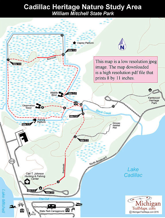
Accessed from the Carl T. Johnson Hunting and Fishing Center and part of William Mitchell State Park, the nature study area contains almost 3 miles of trails that enclose a 70- acre marsh. Black Creek flows through the wetland on its way from Lake Cadillac to Lake Mitchell, making it especially attractive to waterfowl and other water birds that frequent the large lakes.
Hikers have the opportunity to spot mallards, wood ducks, black ducks, and Canada geese during spring and fall migration, plus herons, bitterns, shorebirds, and other wetland-related bird species. Songbirds that nest in the wetland and adjacent habitats include the redwing blackbird, common yellowthroat, yellow warblers and goldfinches while barred owls, red-tailed hawks, and occasionally osprey and bald eagles are observed here. Deer, beavers, muskrats, raccoons, and turtles are common throughout the area.
From the Johnson Center, the trail heads north as a half-mile spur that provides access to a nearly 2-mile loop of dikes encircling the marsh. Following the dike along the perimeter of study area is a 2.8-mile round-trip hike from the interpretive center trailhead. The hike described below is a 2.6-mile outing that includes the most interesting section, the spur across the wetland between posts No. 7 and No. 9.
The trail is not open mountain bikes but does feature a dozen interpretive panels, making it an excellent outing for families. A pair of high powered binoculars are handy here as there are several places along the trail to sit and search the marsh for wildlife. It's also better to hike the trail in the evening, even if it means arriving after the interpretive center is closed. What you encounter alive in the marsh is much more interesting than what's been mounted on the walls at the Hunting and Fishing Center.
| Camping |
| Difficulty - Easy |
| Foot Path |
Geo-referenced maps from MichiganTrailMaps.com range from $1.99 to $2.99 each.
Download the Avenza app from the App Store or Google Play


