Isle Royale NP: Greenstone Ridge Trail-Map 1

Buy the $.99 downloadable map!
(This map is not geo-referenced)Trail Details

This trail is a Michigan classic, a beautiful and personally fulfilling hike from one end of our largest island to the other. Every backpacker should hike the Greenstone at least once. Lucky you if you get to experience it twice.
Although the trail is rated moderate and is easy to follow, there are eight high points that exceed of 1,300 feet and often knee-bending climbs between them. Experienced hikers in good shape can cover the 40-plus miles in 3 days, but the Greenstone can also be a good trail for beginners if they come with light packs and have 4 or 5 days to walk it.
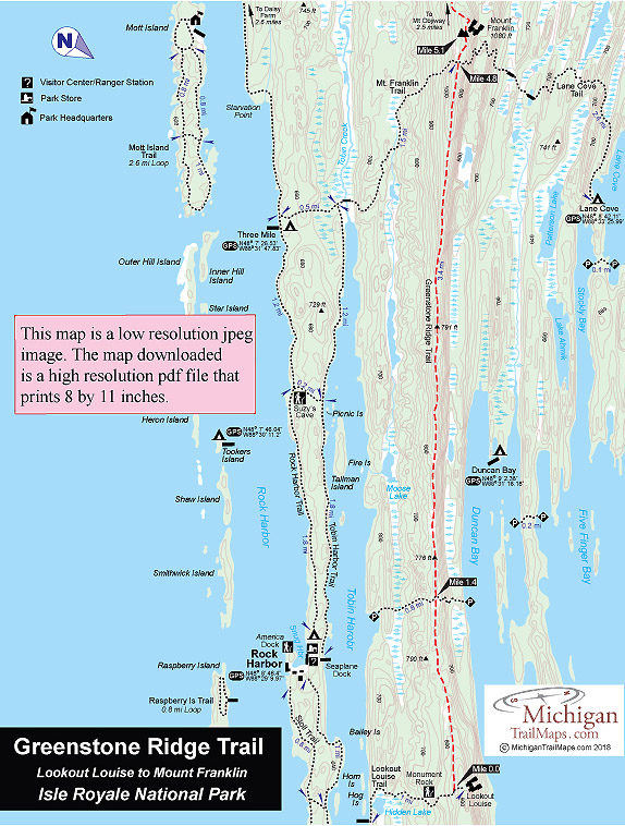
The Greenstone is technically a 40-mile trail that extends from Lookout Louise near the east end of Isle Royale to Windigo on the west end. Few hikers take the time to arrange boat transportation from Rock Harbor across Tobin Harbor to Hidden Lake, the start of the Lookout Louise Trail. Instead most hikers begin with the Rock Harbor Trail and spend their first night at Three-Mile Campground. The following day they take the Mount Franklin Trail to the Greenstone.
Ironically one of the most scenic stretches of the Greenstone – from Lookout Louise to Mount Franklin – is the portion most often skipped. Greenstone Ridge Trail Map 1 covers this stretch, a 5.1-mile trek. For the night you can leave the Greenstone to camp at Three Mile (2.5 miles away), Lane Cove (2.7 miles) or Daisy Farm (4.2 miles).
| Camping |
| Difficulty - Moderate |
| Foot Path |


