320

Trails Reviewed

Find Trails & Maps

Search for Trail
Search by Location
Search by

Back to listing

Isle Royale NP: Greenstone Ridge Trail-Map 2


Buy the Geo-referenced map
for use in the Avenza Maps App

Trail Details

County
Houghton
Regions
Western Upper Peninsula
Latitude
N 48° 06' 29.52"
Longitude
W 088° 36' 27.00"
Distance
4 miles
Trail Type
Foot path
Terrain
Greenstone Ridge
Difficulty
Moderate
Nearest City or Town
Houghton
(map loads here)
view map
Avenza Maps
Geo-referenced maps from MichiganTrailMaps.com are available through Avenza Maps and range from $1.99 to $2.99 each.

Download the Avenza app from the App Store or Google Play

App Store Google Play

The 4-mile stretch of the Greenstone Ridge Trail from Mount Franklin to Sargent Lake is a scenic hike that follows the ridgeline and passes two routes to Daisy Farm Campground. The first is the 1.7-mile Ojibway Trail from Mount Ojibway and the second is the 1.9-mile Daisy Farm Trail. Highlight of this segment is Mount Ojibway that puts you at 1,133 feet with a lookout tower that gives way to views on both sides of the island.
Expand All
Photos
Description
The 4-mile stretch of the Greenstone Ridge Trail from Mount Franklin to Sargent Lake is a scenic hike that follows the ridgeline and passes two routes to Daisy Farm Campground. The first is the 1.7-mile Ojibway Trail from Mount Ojibway and the second is the 1.9-mile Daisy Farm Trail. Highlight of this segment is Mount Ojibway that puts you at 1,133 feet with a lookout tower that gives way to views on both sides of the island.

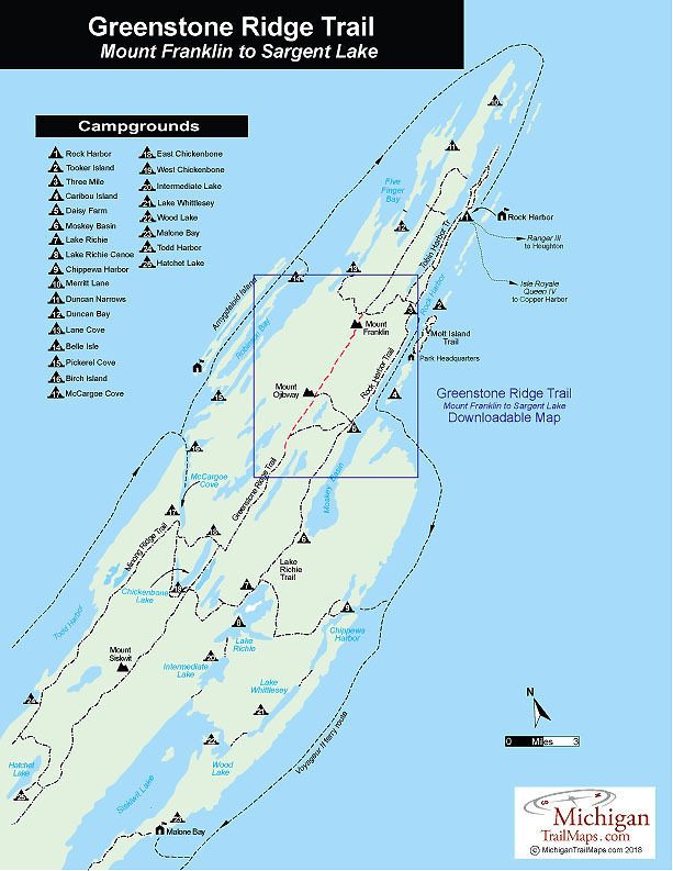
Many backpackers, however, skip this segment of the Greenstone and instead follow the Rock Harbor Trail to Daisy Farm, a shorter route that allows them to easily reach the large campground the day they land at Rock Harbor. Keep in mind that there is little or no water along this stretch of the Greenstone Ridge Trail. If planning to hike from Mount Franklin to West Chickenbone Campground carry 2 quarts of water per person.
Amenities & Services
Camping
Difficulty - Moderate
Foot Path
Trail Guide

The Greenstone Ridge Trail is covered in detail with maps in Isle Royale National Park: Foot Trails & Water Routes by Jim DuFresne. To order the 192-page guide to the Greenstone Ridge Trail and the rest of the wilderness island, Click Here.

Facilities

Shower tokens, clean towel, and bar of soap can be purchased at the camp store at Rock Harbor or Windigo. Some backpackers like to book a room for their final night at Rock Harbor, either at the lodge or in one of the housekeeping units that can be shared by six people and feature small kitchenettes. For reservations, contact the park concessionaire, Forever Resorts (866-644-2003 or 906-337-4993 in summer; www.isleroyaleresort.com).

In the Upper Peninsula, on the way to Isle Royale National Park, the best place to pick up equipment is Downwind Sports which has two stores at 514 N Third St. in Marquette (906-226-7112) and 308 Shelden Ave. in Houghton (906-482-2500). Once on the island, information, maps and backcountry permits can be obtained from the Rock Harbor or Windigo Visitor Centers at the foot of the ferry wharf. There are also small stores at each entry port with limited and very expensive supplies.

Hours & Fees

Isle Royale National Park opens April 16 and closes on Nov. 1 to all visitors for the winter.  The park has a entrance fee of $7 per person per day or an annual pass for $60. You can pay the entrance fee once you arrive at the park or in advance at at pay.gov  and avoid congestion and long waits on the island. All park visitors who plan to camp overnight at campgrounds or cross-country sites are required to obtain a camping permit. This permit can be obtained free of charge at the visitor center at Windigo or Rock Harbor when you arrive or on board Ranger III on the way to the Island.

Directions

To return to Rock Harbor from Windigo after hiking the Greenstone Ridge Trail many backpackers book passage on the Voyageur II. After arriving at Windigo from Minnestoa, the ferry circumnavigates the island clockwise and overnights at Rock Harbor Lodge. The following day, it continues with possible stops at Daisy Farm, Chippewa Harbor Campground, Malone Bay Campground, and Windigo before returning to Grand Portage. The trip not only gets you back to Rock Harbor but provides a view of Isle Royale not seen from the crest of the Greenstone Ridge.

Information

For more information on the Voyageur II contact the Grand Portage – Isle Royale Transportation Line (651-653-5872, 888-746-2305; www.isleroyaleboats.com).


Geo-referenced maps from MichiganTrailMaps.com range from $1.99 to $2.99 each.

Download the Avenza app from the App Store or Google Play

App Store Google Play

Michigan TrailMaps.com Michigan's Premier Trail Resource Contact

Trail Mix News

by travel and outdoor writer Jim DuFresne!

Sign Up
Enews Signup
Find a Trail

Find Trails & Maps

Search for Trail
Search by Location
Search by