320

Trails Reviewed

Find Trails & Maps

Search for Trail
Search by Location
Search by

Back to listing

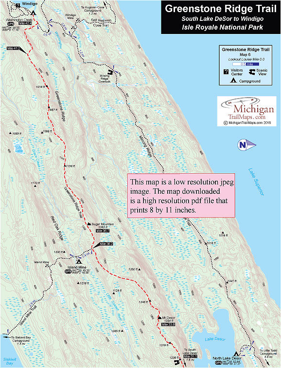
Isle Royale NP: Greenstone Ridge Trail-Map 6


Buy the Geo-referenced map
for use in the Avenza Maps App

Trail Details

County
Houghton
Regions
Western Upper Peninsula
Latitude
N 47° 55' 35.40"
Longitude
W 089° 05' 31.92"
Distance
11.3 miles
Trail Type
Foot path
Terrain
Greenstone Ridge
Difficulty
Moderate to challenging
Nearest City or Town
Houghton
(map loads here)
view map
Avenza Maps
Geo-referenced maps from MichiganTrailMaps.com are available through Avenza Maps and range from $1.99 to $2.99 each.

Download the Avenza app from the App Store or Google Play

App Store Google Play

The Greenstone Ridge Trail from the South Lake Desor Campground to Washington Creek Campground is a long day, a trek of 11.3 miles. For many backpackers, however, this is also their final day so their packs are light and their legs are strong. Just the vision of junk food or a hot shower in Windigo is usually enough to propel them down the trail.
Expand All
Photos
Description
The Greenstone Ridge Trail from the South Lake Desor Campground to Washington Creek Campground is a long day, a trek of 11.3 miles. For many backpackers, however, this is also their final day so their packs are light and their legs are strong. Just the vision of junk food or a hot shower in Windigo is usually enough to propel them down the trail.

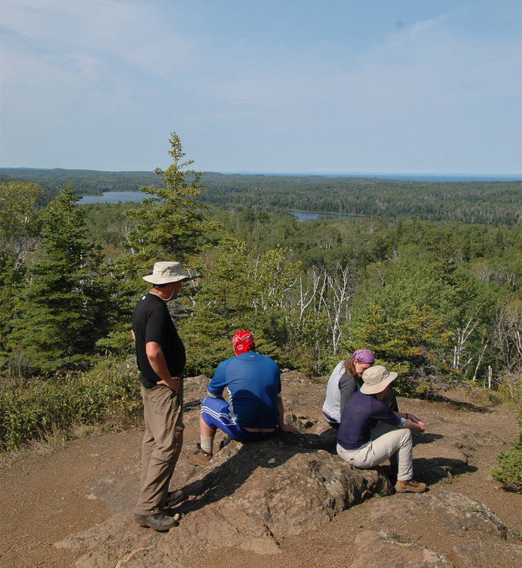
Heading west the Greenstone Ridge Trail departs from the junction to South Lake Desor Campground and immediately starts climbing its namesake ridge. Within 1.5 miles from the junction, a side trail appears and leads you to a rocky clearing in the trees.

From this spot you can see the Canadian shoreline to the north and flat-topped Pie Island in Lake Superior. Enjoy the sun and the breaks in the foliage; these are the last significant views for the remainder of the trail. Most disappointing to backpackers is there are no views from Mount Desor (1394 feet), the highest point on the Island, are Sugar Mountain further west on the trail.
Amenities & Services
Camping
Difficulty - Moderate
Foot Path
Trail Guide

The Greenstone Ridge Trail is covered in detailed with maps in Isle Royale National Park: Foot Trails & Water Routes by Jim DuFresne. To order the 192-page guide to the Greenstone Ridge Trail and the rest of the wilderness island, Click Here.

Facilities

This stretch of the Greenstone Ridge Trail connects two campgrounds; South Lake Desor and Washinton Creek at Windigo, and provides access to Island Mine and Sistiwit Bay Campgrounds via the Island Mine Trail. Island Mine Campground is only a half mile from the Greenstone Ridge Trail near Sugar Mountain.

The Island Mine Campground is deep in the sugar-maple forest and provides individual and group campsites and pit toilets. Water is available from a nearby stream that\'s cool and clear. This is the only campground not bordering an inland lake, cove, or Lake Superior, but from late September to mid-October, when the trees show off their brilliant fail colors, Island Mine is a great place to pitch a tent.

Washington Creek Campground has 10 shelters along the creek, toilets, tables, and piped-in water, along with individual and group campsites. There is often a camp moose-– if not a couple – visiting the stream at dusk. Keep in mind that Washington Creek is an extremely popular place for backpackers to spend a night or two. If there is an open shelter, stake it out before heading to the showers or camp store in Windigo.

Shower tokens, a clean towel, and a bar of soap can be purchased at the camp store in Windigo. Some backpackers like to book a rustic cabin in Windigo that offers basic accommodations. For reservations, contact the park concessionaire, Forever Resorts (866-644-2003 or 906-337-4993 in summer; www.isleroyaleresort.com).

Hours & Fees

Isle Royale National Park opens April 16 and closes on Nov. 1 to all visitors for the winter.  The park has an entrance fee of $7 per person per day or an annual pass for $60. You can pay the entrance fee once you arrive at the park or in advance at pay.gov  and avoid congestion and long waits on the island. All park visitors who plan to camp overnight at campgrounds or cross-country sites are required to obtain a camping permit. This permit can be obtained free of charge at the visitor center at Windigo or Rock Harbor when you arrive or onboard Ranger III on the way to the Island.

Directions

To return to Rock Harbor from Windigo after hiking the Greenstone Ridge Trail many backpackers book passage on the Voyageur II. After arriving at Windigo from Minnesota, the ferry circumnavigates the island clockwise and overnights at Rock Harbor Lodge. The following day, it continues with possible stops at Daisy Farm, Chippewa Harbor Campground, Malone Bay Campground, and Windigo before returning to Grand Portage. The trip not only gets you back to Rock Harbor but provides a view of Isle Royale not seen from the crest of the Greenstone Ridge.

Information

For more information on the Voyageur II contact the Grand Portage – Isle Royale Transportation Line (651-653-5872, 888-746-2305; www.isleroyaleboats.com).


Geo-referenced maps from MichiganTrailMaps.com range from $1.99 to $2.99 each.

Download the Avenza app from the App Store or Google Play

App Store Google Play

Michigan TrailMaps.com Michigan's Premier Trail Resource Contact

Trail Mix News

by travel and outdoor writer Jim DuFresne!

Sign Up
Enews Signup
Find a Trail

Find Trails & Maps

Search for Trail
Search by Location
Search by