Isle Royale NP: Indian Portage & Lake Mason Trails

Buy the $.99 downloadable map!
(This map is not geo-referenced)Trail Details

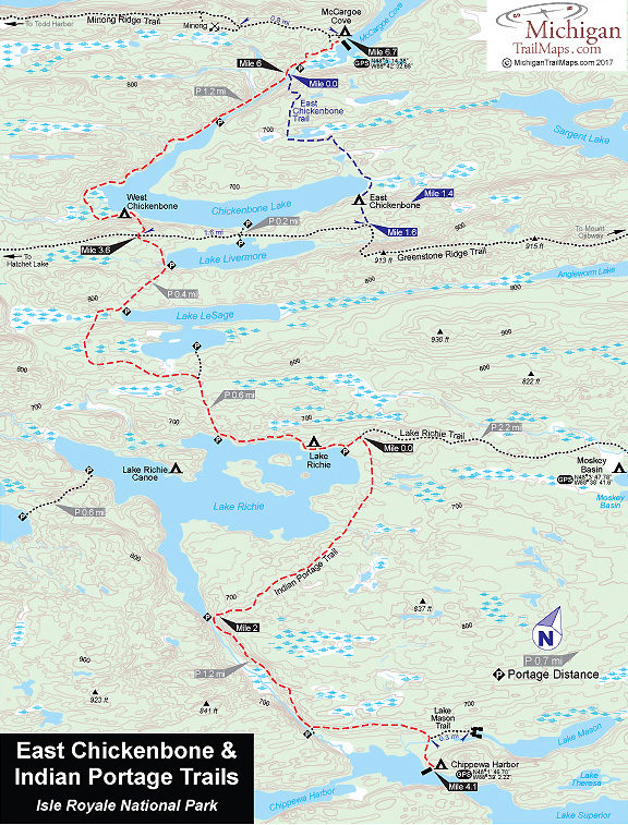
The path traverses just about every type of terrain found in the park. Along the way you will pass lakes, swamps, and beaver ponds. You will climb ridges and pass through dense forest and sections still scarred by the 1936 fire.
Most hikers arrive on either the Greenstone Ridge Trail or the Rock Harbor and Lake Richie Trails and head north or south on Indian Portage at this point. But you could also utilize the Voyageur II to be dropped off at either end of Indian Portage Trail at Chippewa Harbor or McCargoe Cove.
From the Lake Richie Trail junction, the Indian Portage Trail heads west and then north to McCargoe Cove, reaching the picturesque campground in 6.7 miles. Along the way you cross the Greenstone Ridge Trail and shortly after that reach West Chickenbone Campground.
Heading south from Lake Richie Trail, Indian Portage Trail reaches the tip of the south arm of Lake Richie and then follows a bluff above the lake’s drainage to Chippewa Harbor, reaching the campground in 4.1 miles.
Chippewa Harbor Campground is another favorite for hikers because its four shelters are situated high above the water, with a good view of the harbor. The narrow entrance from Lake Superior, surrounded by rugged bluffs and small islands, is especially beautiful. The campground also has individual and group campsites, pit toilets, tables, and a dock.
Right before reaching the campground, the trail passes the side trail to Lake Mason. The side trail takes about 10 minutes one way and is an easy 0.3-mile walk to the rock bluff that overlooks the west end of the lake.
| Camping |
| Difficulty - Moderate |
| Foot Path |


