320

Trails Reviewed

Find Trails & Maps

Search for Trail
Search by Location
Search by

Back to listing

Lost Lake Pathway

Trail Details

County
Grand Traverse
Regions
Northwest
Latitude
N 44° 40' 17.40"
Longitude
W 085° 47' 54.60"
Distance
6.2 mile loop
Trail Type
Multi-use trail
Terrain
Lost Lake, bogs, woods
Difficulty
Moderate
Nearest City or Town
Interlochen
(map loads here)
view map
Located just inside the Grand Traverse/Benzie county line, not far from the Lake Ann Pathway, Lost Lake is another pathway connected to a state forest campground, providing campers with a place to hike or ride their mountain bikes. In the winter it attracts a fair number of cross country skiers. Unlike Lake Ann, Lost Lake Pathway is not nearly as hilly. Its non-threatening terrain makes it an easy ride and a popular destination for even the most novice mountain biker.The trail system totals almost 6.5 miles with the perimeter being a 6.3-mile outing that passes three lakes and several open bogs. Most of the loop, however, is a relatively level ride through the woods.
Expand All
Photos
Description
Located just inside the Grand Traverse/Benzie county line, not far from the Lake Ann Pathway, Lost Lake is another pathway connected to a state forest campground, providing campers with a place to hike or ride their mountain bikes. In the winter it attracts a fair number of cross country skiers. Unlike Lake Ann, Lost Lake Pathway is not nearly as hilly. Its non-threatening terrain makes it an easy ride and a popular destination for even the most novice mountain biker.

The trail system totals almost 6.5 miles with the perimeter being a 6.3-mile outing that passes three lakes and several open bogs. Most of the loop, however, is a relatively level ride through the woods.

By starting at the Lake Dubonnet dam near post No. 3, you can reduce the trail to a 3.75-mile loop. The terrain is easy but interesting. The topography, transitional small sink hole lakes created by glacial debris and melting ice deposits, is typical of how the glaciers formed this region. Lake Dubonnet itself, however, was created in 1956 when a stream was dammed to improve fishing and waterfowl habitat.

Lake Dubonnet State Forest Campground, a rustic facility of 50 sites, provides drinking water and vault toilets along the first loop. Opposite of it is a trail camp for equestrians as the Michigan Shore-to-Shore Trail passes through the area. The two trails intersect but their users are carefully separated to avoid any conflicts. Horseback riders stay on dirt roads and two-tracks and off the pathway.

Originally constructed as a nature trail, complete with an interpretive brochure, Lost Lake is regarded as a single track by mountain bikers but its path is wide. Riders do need to keep an eye out for an occasional patch of sand but overall the trail surface is hard packed. Hikers have none of this to worry about but should pack along bug repellent in May and June.
Amenities & Services
Camping
Difficulty - Moderate
Dog Friendly
Multi-use Trail
Trail Guide

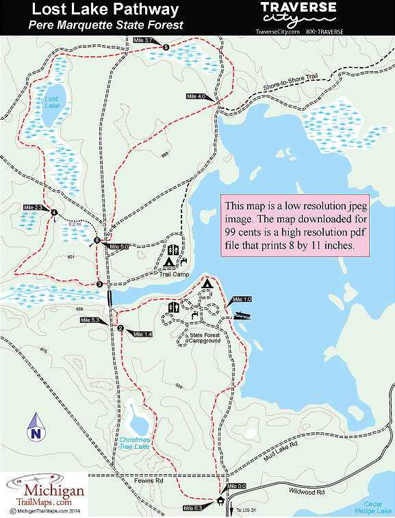
The pathway departs the parking area in two different directions. The segment that heads north for the campground is well posted with a display board and donation canister. Departing the parking to the east, but unmarked, is the segment to Christmas Tree Lake. Most users begin with the segment to the campground because it’s so well marked.

You quickly cross Fewins Road and then within a half mile cross the campground entrance road and spot Lake Dubonnet through the trees. You follow the lake shore for almost a mile, cutting through the campground boat launch at Mile 0.8 and passing a water pump just beyond that. The trail swings west and follows the west arm of the lake and then at Mile 1.4 swings south briefly to arrive at post No. 2.

Here you descend to a dirt road and follow it north (right) across the Lake Dubonnet dam. On the north side to the left is post No. 3 where you re-enter the woods. Head west at the post to stay in the woods but skirt the creek basin, most of it an open marsh. At Mile 2 the trail swings north and you encounter the first climb of the day. You cross a pair of old two-tracks and arrive at post No. 4 at Mile 2.3 where there is a skier’s bench.

Head north (left) at the post and you’ll immediately cross a two-track and then at Mile 2.6 spot Lost Lake for the first time. This scenic little lake is set in the middle of a large bog. The lake once occupied the entire bog but natural plant succession is gradually filling it in and eventually it will disappear, the fate of many small pit lakes created by the glaciers some 10,000 years ago.

For the next half mile you skirt more than half the lake in the most scenic section of the pathway before leaving it behind and crossing another two-track. At Mile 3.5 the trail merges onto an abandoned railroad grade leftover the logging days and then within a quarter mile arrives at post No. 5. This is a pleasant spot where a bench sits in a stand of tall red pine but overlooks another large bog that supports, among other species, wild blueberries.

In the next stretch the pathway crosses four dirt roads at Mile 3.9, Mile 4, Mile 4.7 and Mile 4.9 along a stretch that remains in the woods but contains a few dips and rises. At Mile 5 you arrive at post No. 6. Head south (left) to return to post No. 3 within a quarter mile and then backtrack to post No. 2 along the dirt road across the Lake Dubonnet Dam.

The final mile is interesting if you’re hiking and fun if you’re on a mountain bike. The trail is fast and firm as it meanders though pine and hardwood and across a ridge overlooking Christmas Tree Lake. Eventually you re-cross Fewins Road and emerge at the trailhead parking area.

Facilities

The main trailhead features a large parking area and a display board. You can also park on the north side of the Lake Dubonnet dam. Lake Dubonnet State Forest Campground is a 50-site rustic campground that includes a boat launch, a handicapped-accessible fishing pier, water and vault toilets.

Hours & Fees

The trail is open year-round and during the winter attracts cross-country skiers and snowshoers. There is no user or vehicle fee required but there is a donation canister at the trailhead for its upkeep. Please give!

Directions

From Traverse City head west on US-31 for 14 miles, or a mile past M-137, and then turn north on Wildwood Road beside Interlochen Golf Course. It's a mile to the trailhead and parking lot.

Information

Contact the Traverse City DNR Field Office at (231) 922-5280. For travel information contact Traverse City Tourism (800-872-8377;  www.traversecity.com).


Geo-referenced maps from MichiganTrailMaps.com range from $1.99 to $2.99 each.

Download the Avenza app from the App Store or Google Play

App Store Google Play

Michigan TrailMaps.com Michigan's Premier Trail Resource Contact

Trail Mix News

by travel and outdoor writer Jim DuFresne!

Sign Up
Enews Signup
Find a Trail

Find Trails & Maps

Search for Trail
Search by Location
Search by