322

Trails Reviewed

Find Trails & Maps

Search for Trail
Search by Location
Search by

Back to listing

Lost Twin Lakes Pathway
Trail Details

County
Roscommon
Regions
Heartland
Latitude
N 44° 12' 53.28"
Longitude
W 084° 42' 9.36"
Distance
3.4 miles
Trail Type
Foot path
Terrain
Old Growth pines, sinkholes
Difficulty
Moderate
Nearest City or Town
Houghton Lake
(map loads here)
view map
Lost Twin Lakes is a 3.4-mile loop that was built in the mid-1980s. It remained a soggy, lightly-used pathway until 1999 when members of Boy Scout Troop 944 turned the trail into an Eagle Scout project and constructed a series of bridges and boardwalks over the wettest parts.Thanks to the Scouts, the trail is a much drier hike now but still remains relatively obscure. Much of that is due to its remote location. Part of the Au Sable State Forest, the trailhead is south of Houghton Lake along Reserve Road (County Road 400), a winding dirt road with few signs.This pathway is for people who like to walk in the woods.The main attraction of Lost Twin Lakesarethe century-old white pines scatter ...
Expand All
Photos
Description

Lost Twin Lakes is a 3.4-mile loop that was built in the mid-1980s. It remained a soggy, lightly-used pathway until 1999 when members of Boy Scout Troop 944 turned the trail into an Eagle Scout project and constructed a series of bridges and boardwalks over the wettest parts.

 Thanks to the Scouts, the trail is a much drier hike now but still remains relatively obscure. Much of that is due to its remote location. Part of the Au Sable State Forest, the trailhead is south of Houghton Lake along Reserve Road (County Road 400), a winding dirt road with few signs.

This pathway is for people who like to walk in the woods. The main attraction of Lost Twin Lakes are the century-old white pines scattered along the trail, giant trees that survived waves of loggers in the late 1800s. The pathway also features an interesting topography that includes ridges, sinkholes, wetlands and swamps and those small namesake lakes that gives it a wonderful North Woods ambience.

Like all state forest pathways, Lost Twin Lakes is open to Nordic skiing and snowshoeing as well as mountain biking. But the trail isn’t groomed in the winter while off-road cyclists usually bypass it, choosing instead trails with more mileage that are easier to access from I-75 or US-131.

Amenities & Services
Difficulty - Moderate
Dog Friendly
Foot Path
Trail Guide

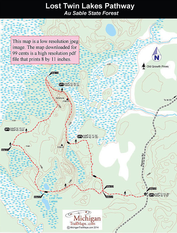
Within a third of a mile of departing the trailhead parking lot, you pass the first giant pines of the trek and arrive at the trail's only junction. Following the loop in a counter-clockwise direction, the first Boy Scout-built bridge is reached at Mile 0.5

Beyond the bridge the pathway begins climbing and for most of the east half of the loop follows the crest of an ancient glacial moraine. This narrow, forested ridge is bordered on both sides by wetlands and from its crest you’re rewarded with glimpses and vistas of marshland and patches of open water. On its slope are a scattering of old growth pines. The first are seen in less than a mile from the trailhead, a more impressive set are seen at Mile 1.3 after the trail reaches a high point of 1,180 feet.

 At the north end of the ridge, just before the loop swings sharply south for it's return, are a series of sinkholes, conical depressions that are the result of underground streams dissolving the limestone bedrock. The sinkholes aren't visible from the pathway but by leaving the trail to the west you can quickly spot them. Also at the north end of the ridge is a short spur that leads to the East Branch of Wolf Creek, a scenic setting and a place to linger if the mosquitoes aren’t out in full force.

 Heading south now, the pathway levels out but remains fairly dry. At Mile 2 giant white pines begin the appearing along the trail and after the trail swings sharply east you pass between two towering pines standing guard on both sides of the pathway. These are the largest trees along the trail and some could be 150 years old if not older.

The pathway arrives at a wavy bridge at Mile 2.7 and the creek that it crosses connects Lost Twin Lakes. They’re easy to miss if you’re staring up at the crowns of giant pines but the main one to the south is more easily viewed than its twin to the north. Both lakes are tiny, the largest one only two acres, and shallow, making them ideal havens for wildlife.

In less than a half mile you return to the junction and backtrack the first segment to return to the parking area at Mile 3.4

Facilities

 There are no facilities at the trailhead other than parking and a posted trail map. Bring drinking water while from May through July bug repellent is a requirement in every daypack.

Hours & Fees

A state park annual or daily vehicle pass is required to hike Lost Twin Lakes Pathway but there is no self-registration at the trailhead. 

Directions

From I-75, depart at exit 227 and head west on M-55 for 11 miles. Turn south on Reserve Road (County Road 400) and follow it 6.4 miles. 

Information

For more information call the Roscommon DNR Office (989-275-5151).

For lodging or additional travel information contact the West Michigan Travel Association (616-246-2217; www.WMTA.org).


Geo-referenced maps from MichiganTrailMaps.com range from $1.99 to $2.99 each.

Download the Avenza app from the App Store or Google Play

App Store Google Play

Michigan TrailMaps.com Michigan's Premier Trail Resource Contact

Trail Mix News

by travel and outdoor writer Jim DuFresne!

Sign Up
Enews Signup
Find a Trail

Find Trails & Maps

Search for Trail
Search by Location
Search by