320

Trails Reviewed

Find Trails & Maps

Search for Trail
Search by Location
Search by

Back to listing

Ludington State Park

Trail Details

County
Mason
Regions
Lake Michigan
Latitude
N 44° 01' 41.52"
Longitude
W 086° 30' 16.20"
Distance
0.7 to 6.0 miles
Trail Type
Foot path, beach walk, boardwalk, interpretive trail
Terrain
Lake Michigan beach, dunes, Lost Lake, Big Sable River, Hamlin Lake
Difficulty
Easy to moderate
Nearest City or Town
Ludington
(map loads here)
view map
The largest state park along Lake Michigan and one of the largest in the Lower Peninsula is Ludington. The 5,300-acre state park in Mason County includes 5.5 miles of Great Lake shoreline, 4 miles along popular Hamlin Lake and a 1,699-acre Wilderness Natural Area. The terrain varies from wind-blown sand dunes to gently rolling pine forests. Much of the dunes, from Lake Michigan to a half mile inland, are treeless areas of dune grass and scrub. Others are covered in jack pine.The state parks most picturesque fixture is Big Point Sable Lighthouse, an impressive tower among the dunes that was built in 1867. From the lighthouse to the northern boundary is the parks Wilderness Natural Area, a ...
Expand All
Photos
Description
The largest state park along Lake Michigan and one of the largest in the Lower Peninsula is Ludington. The 5,300-acre state park in Mason County includes 5.5 miles of Great Lake shoreline, 4 miles along popular Hamlin Lake and a 1,699-acre Wilderness Natural Area. The terrain varies from wind-blown sand dunes to gently rolling pine forests. Much of the dunes, from Lake Michigan to a half mile inland, are treeless areas of dune grass and scrub. Others are covered in jack pine.

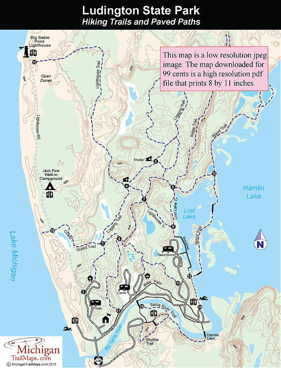
The state park's most picturesque fixture is Big Point Sable Lighthouse, an impressive tower among the dunes that was built in 1867. From the lighthouse to the northern boundary is the park's Wilderness Natural Area, a trailless and undeveloped section of mostly forested dunes. This unique "dune wilderness" continues, as bordering Ludington to the north is Nordhouse Dunes, a declared federal wilderness that is managed by the Manistee National Forest.

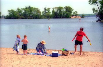
The miles of sandy Lake Michigan shoreline, the most of any unit in the state, the many coves and inlets of Hamlin Lake and the appeal of dune country have made Ludington a popular park. Ludington draws 840,000 visitors a year as one of the most heavily used units in the state park system. Although there is year-round activity in the park, the majority of the visitors come during the summer to enjoy the beaches, campground and scenic network of foot trails.

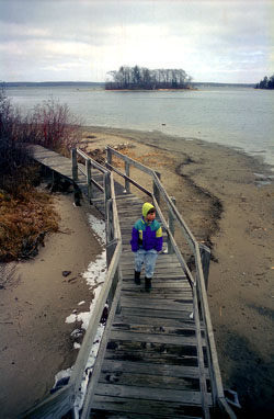
The park’s trail system was re-routed in 2000 and there are now eight named and color-coded hiking trails that form an 21-mile network. Almost all the routes are located north of the Sable River, except for Sable River Trail and the mile-long Skyline Trail that features an extensive boardwalk on the crest of a dune. One of the more popular destinations for hikers is the Big Point Sable Lighthouse, that can be reached via the Logging and Lighthouse Trails, an access road open only to park maintenance vehicles or a 2-mile walk along the shoreline.

An excellent day hike is to follow the Ridge Trail, which passes several highpoints with good views of Hamlin Lake and then return along Island and Lost Lake Trail, which skirts the interesting shoreline between Hamlin and Lost lakes. The trailhead for Ridge Trail is in Cedar Campground, while Lost Lake Trail begins from the day-use area of Hamlin Lake. The entire loop would be a 4- to 6-hour hike.

The most unusual trail in the park is the Ludington State Park Canoe Trail, a 4-mile, three-hour paddle into a serene world of ponds, coves and marshes along the southwest shore of Hamlin Lake. Built in 1992, the canoe trail was the first of its kind in a state park and is still the longest one in Michigan. It features directional signs to keep you on course, small landing docks and an interpretive brochure that explains the passing scenery. Six very short portages allow you to loop through protective bayous and ponds to totally escape the motorized traffic on Hamlin Lake.

Ludington State Park also has 2 miles of paved bicycle paths that connect all three campgrounds and cross Sable River to Skyline Trail and 10 miles of Nordic trails. North Ski Trails are a 6-mile loop that begins at the Winter Warming Shelter and follows the Loggers Trail most of the way. The South Ski Trails depart from near Sky Line Trail and consist of a loop with four cross spurs for runs that range from 1.5 miles to over 4 miles in length.
Amenities & Services
Camping
Difficulty - Easy
Difficulty - Moderate
Foot Path
Groomed Classic Skiing
Paved Trail
Trail Guide

Click on highlighted trails for individual trail page:

Lighthouse Trail/Beach Walk 4.3 miles Hike
Ridge and Island Trails 4.8 miles Hike
Skyline Trail 1.0 mile Interpretive trail
Logging Trail 2.7 miles Hike
Sable River Trail 0.7 mile Hike
Coast Guard Trail 1.0 mile - Hike
Lighthouse Access Rd 2.0 miles Walk-in camp
?Bike Path 2.0 miles Paved path
North Ski Trails 6.0 miles Nordic ski
South Ski Trails 4.0 miles Nordic ski
Canoe Trail 4.0 miles Paddle

Facilities

Along with 5 miles of Lake Michigan beach, Ludington State Park has 355 sites in three modern campgrounds: Pines, Cedar and Beechwood. Each campground has electricity, restrooms and showers while Cedar Campground also has a small loop of eight tent-only sites. The park also features 10 walk-in sites at Jack Pine Campground, a hike of a mile along Lighthouse Road.

Ludington's campgrounds are booked daily July through Labor Day and are full on weekends beginning in Memorial Day. Late April is a particularly pleasant time to camp as reservations are unnecessary and the park is practically empty at that time of year. The campground is open year round but the modern restrooms are available only from April 15 to Nov. 1.

The park maintains two day-use areas, one on Lake Michigan just north of where Sable River empties into the Great Lake and a second on Hamlin Lake. Both have parking, bathhouses and concession stores, but Hamlin beach is often the more popular of the two early in the year as its water warms up quicker. M-116 follows the Lake Michigan shoreline for almost 3 miles after entering the park, and it's common during the summer for visitors to pull over anywhere along the road to enjoy a section of the beach.

Interpretive Center

Big Sable Point Light Station was built in 1867 and today includes an interpretive room and a gift shop on the first floor and the tower that visitors allowed to climb for a view of Lake Michigan. For more information about Big Sable Point Lighthouse contact the Sable Points Lighthouse Keepers Association (231-845-7417, http://www.splka.org/).

Hours & Fees

The park is open year round and a vehicle permit is required to enter. Big Sable Point Lighthouse is open daily from May through October from 10 a.m. to 5 p.m. when visitors can climb the tower for a $2 donation.

Directions

The state park is 8.5 miles north of the city of Ludington at the end of M-116.

Information

For more information contact the Ludington State Park headquarters (231-843-2423). For a campsite or cabin reservation contact Michigan State Park Central Reservations (800-447-2757; www.midnrreservations.com).

For lodging and additional travel information contact the West Michigan Tourist Association (616-245-2217; www.WMTA.org).


Geo-referenced maps from MichiganTrailMaps.com range from $1.99 to $2.99 each.

Download the Avenza app from the App Store or Google Play

App Store Google Play

Michigan TrailMaps.com Michigan's Premier Trail Resource Contact

Trail Mix News

by travel and outdoor writer Jim DuFresne!

Sign Up
Enews Signup
Find a Trail

Find Trails & Maps

Search for Trail
Search by Location
Search by