Negwegon State Park: Chippewa Trail

Buy the $.99 downloadable map!
(This map is not geo-referenced)Trail Details

But beyond the beautiful sandy beaches and 6.5 miles of undeveloped shoreline, Negwegon is a mixture of lowland areas and small ridges with pockets of wetlands and meadows mixed in with stands of mature pine forests, hardwoods and aspen. An abundance of wildlife, from bald eagles and wild turkeys to whitetail deer and black bears, thrive in the area.
Acquired in 1962, Negwegon was renamed from Alpena State Park in 1970 to honor a chief of the Ojibway tribe who was loyal to the U.S. side during the War of 1812. Besides the gravel entrance drive and parking area, the only development Negwegon has ever experienced is the construction of a 10-mile trail system in the early 1990s which was enhanced with the addition of four backcountry campsites in 2009.
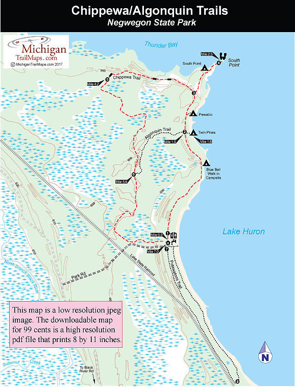
The trail system at Negwegon is divided into three loops with posted trailheads located in the parking area. Heading south is the Potawatomi Trail, a 3.3-mile loop that hugs Lake Huron before swinging inland for its return. Departing to the north is the Chippewa Trail, a 7-mile loop past all four backcountry campsites and the spectacular views at the end of South Point, making it one of the finest treks on the sunrise side of the state. A crossover spur labeled Algonquin Trail shortens the loop to 3.7 miles.
The hike to the sites range from a mile to 2.2 miles and the only amenities they feature are a picnic table, fire ring, wilderness toilet and a bear pole. But all are on the Lake Huron shoreline, rewarding campers who spend the energy to hike in with quiet evenings and spectacular sunrises.
| Camping |
| Difficulty - Moderate |
| Dog Friendly |
| Foot Path |


