320

Trails Reviewed

Find Trails & Maps

Search for Trail
Search by Location
Search by

Back to listing

North Western State Trail

Trail Details

County
Emmet
Regions
Northwest
Distance
32 miles
Trail Type
Paved and compacted limestone
Terrain
Inland lakes and rural Northern Michigan
Difficulty
Moderate
Nearest City or Town
Petoskey
(map loads here)
view map
Formed in 1854, the Grand Rapids and Indiana Railroad began in Richmond, Indiana and reached the Straits of Mackinac in 1882 when the segment known as the Fishing Line was opened from Petoskey to Mackinaw City.The railroad first haul logs and served to accelerate the settlement of Northern Michigan, a largely wilderness region in the mid-19th century. Then the GRI turned to tourism when it teamed up with the Michigan Central Railroad to build the Grand Hotel on Mackinac Island in 1887. At the height of its service in the early 1890s, the GRI had a fleet of 66 locomotives and 3,100 cars and had expanded to Cincinnati, Ohio to become the longest north-south line in the country.Eventually a ...
Expand All
Photos
Description

Formed in 1854, the Grand Rapids and Indiana Railroad began in Richmond, Indiana and reached the Straits of Mackinac in 1882 when the segment known as “the Fishing Line” was opened from Petoskey to Mackinaw City.

The railroad first haul logs and served to accelerate the settlement of Northern Michigan, a largely wilderness region in the mid-19th century. Then the GR&I turned to tourism when it teamed up with the Michigan Central Railroad to build the Grand Hotel on Mackinac Island in 1887. At the height of its service in the early 1890s, the GR&I had a fleet of 66 locomotives and 3,100 cars and had expanded to Cincinnati, Ohio to become the longest north-south line in the country.

Eventually a railroad that hauled lumber, settlers and tourists gave way to trail users when the Michigan Department of Transportation purchased 1,125 acres of GR&I rail bed in 1994. The purchased lead to the creation of White Pine Trail State Park, a 92-mile rail-trail from Grand Rapids to Cadillac.

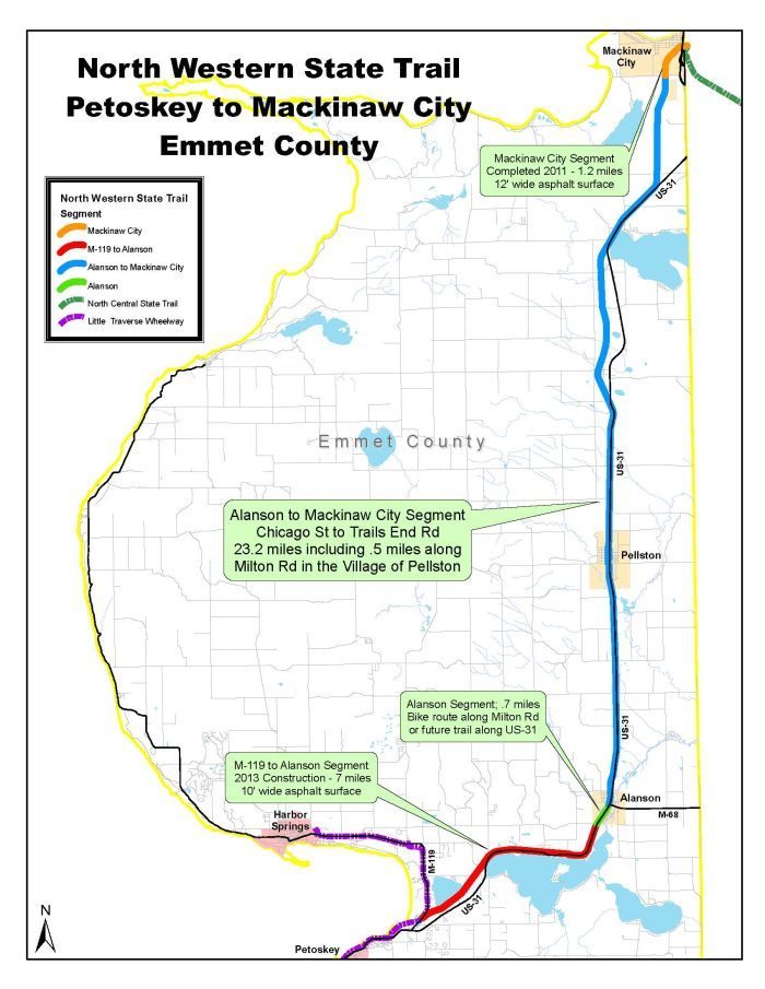
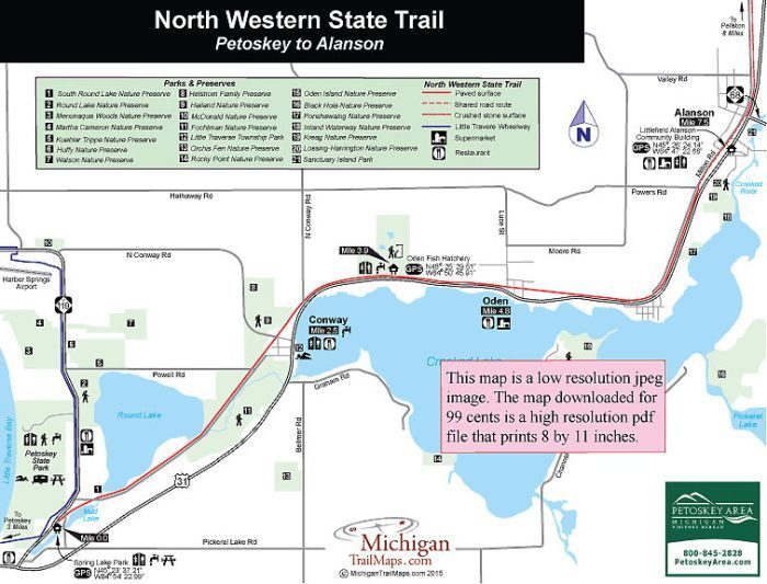
The Fishing Line became the second GR&I rail-to-trail conversion. Formerly known as the Petoskey-to- Mackinaw City Trail, the North Western State Trail is a 32-mile route from Spring Lake Park on M-119 near Petoskey to downtown Mackinaw City. In between the trail passes through a handful quaint villages and towns, skirts the shore of several lakes and provides access to a dozen preserves, parks and beaches.

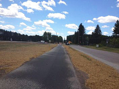
The North Western State Trail is a work in progress. In 2012, the 7.5-mile segment from Spring Lake to Alanson was paved and is covered separately on this web site with its own map. The rest of the trail – the 24.5 miles from Alanson to Mackinaw City – was resurfaced with compacted limestone in 2015, making it ideal for hybrid and mountain bikes as well as hikers. 

Amenities & Services
Difficulty - Moderate
Dog Friendly
Multi-use Trail
Paved Trail
Trail Guide

The Spring Lake to Alanson section of the trail was paved in 2012 and is without a doubt the most scenic and interesting segment of the North Western. It has its own page MichiganTrailMaps.com website.

Alanson is reached at Mile 7.5 along a shared road route with Milton Road. At Chicago Street, the North Western State Trail departs Alanson as a surface of compacted limestone that parallels Milton Road for more than 2 miles before crossing it at Mile 9.7. The trail remains on the west side of US-31 as it heads north and reaches Pellston at Mile 15.5.

Within Pellston a half-mile segment of the North Western is paved and on the north side of the village passes in front of the Pellston Regional Airport with its distinctive rustic log passenger terminal where restrooms and drinking water are available. Pellston features quaint main street with restaurants and stores while nearby Pellston Pioneer Park, accessed from Mill Street in the southwest quarter of the village, features restrooms, drinking water and a picnic area.

Once past the airport, the North Western crosses Ely Road and continues to hug US-31 for the next 5 miles. It then swings away from the US-31 and arrives on the far west side of Levering at Mile 21.5. There is no trailhead or parking along the trail here but by following Mill Street east for four blocks you will reach restaurants and shops of the town’s business district. 

The North Western continues to stay a half mile west of US-31 until it swings east and enters Carp Lake on the shores of Paradise Lake at Mile 26.5. Carp Lake can be used as a trailhead as parking is available along with a convenience store and a restaurant. There is also a DNR boat launch along Paradise Trail a half mile south of the blinking light and a block east of US-31.

North of Carp Lake the state trail parallels US-31 for 2.1 miles and then swings due north and runs inland through forest and wetlands to leave the busy highway behind. At Trails End Road, reached at Mile 30.8, the North Western becomes an asphalt path for the remaining 1.2 miles. It heads north and then swings east to pass underneath I-75 into the heart of Mackinaw City. The large Mackinaw City Trailhead is located on the backside of the Baymont Hotel and the Mackinaw Crossing shopping and entertainment area off Mackinaw Crossing Drive. Within a block or two in almost any direction are restaurants, stores, ice cream parlors and fudge shops.

The trailhead serves as a major junction of trails. It represents the northernmost point of the North Country Trail in Lower Peninsula as well as the northern terminus of the Midland-to-Mackinac Trail. Also departing from here is the North Central State Trail that heads south 61.9 miles for Gaylord.  

Facilities

There are restrooms, drinking water and parking at Spring Lake Park near Petoskey, Michigan Fisheries Visitors Center in Oden and the Mackinaw City Trailhead. The North Western State Trail also passes through seven villages with restaurants and convenience stores.

Hours & Fees

The North Western State Trail is open to all non-motorized uses year-round, and to snowmobiles from December 1 to March 31.

Directions

There three main trailheads with parking for the North Western State Trail. Spring Lake Park anchors the southern end and is reached from US-31 by heading north from Petoskey and then continuing north (left) on M-119. Within a half mile the park will be posted on the right. The Michigan Fisheries Visitors Center on US-31 in Oden also serves as a trailhead. At the north end the North Western Trail ends at the Mackinaw City Trailhead on the backside of the Mackinaw Crossing shopping and entertainment area off of Mackinaw Crossing Drive. Additional parking is available at Pellston Railroad Depot and on side streets in several other small towns along the way. 

Information

For more information on the trail contact the Top of Michigan Trails Council (231-348-8280;  www.trailscouncil.org). For more on lodging and other attractions in the area contact the Petoskey Area Visitors Bureau (800-845-2828; www.petoskeyarea.com).

Files

Geo-referenced maps from MichiganTrailMaps.com range from $1.99 to $2.99 each.

Download the Avenza app from the App Store or Google Play

App Store Google Play

Michigan TrailMaps.com Michigan's Premier Trail Resource Contact

Trail Mix News

by travel and outdoor writer Jim DuFresne!

Sign Up
Enews Signup
Find a Trail

Find Trails & Maps

Search for Trail
Search by Location
Search by