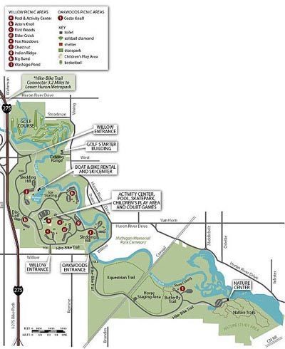
320

Trails Reviewed

Find Trails & Maps

Search for Trail
Search by Location
Search by

Back to listing

Oakwoods Metropark

Trail Details

County
Wayne
Regions
Southeast
Latitude
N 42° 06' 51.48"
Longitude
W 083° 21' 25.92"
Distance
700 feet to 2 miles
Trail Type
Interpretive trail
Terrain
Woods and Huron River
Difficulty
Easy
Nearest City or Town
New Boston
(map loads here)
view map
Oakwoods Metropark is a 1,700-acre unit of the Huron-Clinton Metropolitan Authority, which oversees a system of thirteen parks along the watersheds of the Huron and Clinton Rivers. Oakwoods includes a stretch of the Huron River just upstream from the Flat Rock Dam. Here the Huron is a sluggish waterway filled with marshy islands and small bayous, a perfect place for waterfowl and bird life to gather.Most of the river lies in a 400-acre Nature Study Area that features a nature center and is accessed by four interpretive trails, ranging from 700 feet in length to 2 miles. Other trails in the park include a 3-mile segment of the paved hike-bike trail that winds 15 miles through Lower Huron, ...
Expand All
Photos
Description

Oakwoods Metropark is a 1,700-acre unit of the Huron-Clinton Metropolitan Authority, which oversees a system of thirteen parks along the watersheds of the Huron and Clinton Rivers. Oakwoods includes a stretch of the Huron River just upstream from the Flat Rock Dam. Here the Huron is a sluggish waterway filled with marshy islands and small bayous, a perfect place for waterfowl and bird life to gather.

Most of the river lies in a 400-acre Nature Study Area that features a nature center and is accessed by four interpretive trails, ranging from 700 feet in length to 2 miles. Other trails in the park include a 3-mile segment of the paved hike-bike trail that winds 15 miles through Lower Huron, Oakwoods and Willow Metroparks and a mile-long marked canoe route called Walk-in-Water Trail.

Overall the terrain at Oakwoods is flat and much of it open, grassy meadows, making hiking and cycling easy. But the interpretive trails wind through a wood lot along the Huron River for a far more scenic walk and one that appeals to young children.

Amenities & Services
Difficulty - Easy
Foot Path
Multi-use Trail
Paved Trail
Trail Guide

Click on highlighted trails for individual trail page:

Split Log Trail 700 feet Interpretive
Big Tree Nature Trail 0.75 miles Interpretive
Sky-Come-Down Nature Trail 1.0 miles Interpretive
Long Bark Nature Trail 2.0 miles Interpretive
Walk-in-Water Trail 1.0 miles Paddle
Hike-Bike Trail 3.0 miles Paved

Facilities

Oakwoods has picnic areas with tables, grills and shelters and a Voyageur Canoe that is used for naturalist-led paddles on the Huron River.

Nature Center

Oakwoods Nature Center is a good introduction to any day in the park. There are several excellent hands-on displays inside as well as exhibits of live animals. One of the exhibits is a huge turtle pond where more than a dozen turtles will be lazily swimming through the water or climbing onto a large rock to sun themselves under a heat lamp. In addition to the live animals on display, you can peer into a wasp nest nearly three feet long or stop at the wildlife viewing room to watch birds at the bird feeder.

Hours & Fees

The park is open from 8 a.m. to dusk daily and the nature center is open from 10 a.m. to 5 p.m.. daily in the summer. During the school year the hours at the center changes to 1-5 p.m. on weekdays and 10 a.m. to 5 p.m. on weekends. There is a vehicle permit fee is required to enter the park.

Directions

The park is located in the southeast corner of Wayne County and is reached from I-275 by departing at exit 13 and heading east on Sibley Road. Turn south (right) on Huron River Drive and follow it 4 miles to Willow Drive. The park entrance is just west on Willow Drive. It’s a 2-mile drive along the park road to the parking lot and nature center.

Information

Contact the Oakwoods Nature Center (734-782-3956), the park headquarters (800-477-3182) or the Metroparks Authority at (800-477-2757) or www.metroparks.com.

Files

Geo-referenced maps from MichiganTrailMaps.com range from $1.99 to $2.99 each.

Download the Avenza app from the App Store or Google Play

App Store Google Play

Michigan TrailMaps.com Michigan's Premier Trail Resource Contact

Trail Mix News

by travel and outdoor writer Jim DuFresne!

Sign Up
Enews Signup
Find a Trail

Find Trails & Maps

Search for Trail
Search by Location
Search by