320

Trails Reviewed

Find Trails & Maps

Search for Trail
Search by Location
Search by

Back to listing

Ocqueoc Falls Bicentennial Pathway

Trail Details

County
Presque Isle
Regions
Lake Huron (Includes the Thumb)
Latitude
N 45° 23' 45.60"
Longitude
W 084° 03' 19.08"
Distance
0.4 to 6.3-mile loops
Trail Type
Hiking, mountain biking
Terrain
Oceque River, wooded ridges
Difficulty
Moderate
Nearest City or Town
Rogers City
(map loads here)
view map
While the Upper Peninsula has hundreds of waterfalls, the Lower Peninsula has only two, with Ocqueoc Falls being the most popular and accessible one south of the Mackinac Bridge. You can rush from the parking lot to the falls in a couple of minutes, but the best way to turn this stop into an adventure is first to bike or hike a portion of the Ocqueoc Falls Pathway. This Mackinaw State Forest trail consists of four loops; of four loops; 2.8, 3.5, 4.9 and 6.3 miles along with a short universally accessible loop at the beginning. More than just the falls, this is a very scenic area dominated by the river valley and forested by towering pines and hardwoods.
Expand All
Photos
Description
While the Upper Peninsula has hundreds of waterfalls, the Lower Peninsula has only two, with Ocqueoc Falls being the most popular and accessible one south of the Mackinac Bridge. You can rush from the parking lot to the falls in a couple of minutes, but the best way to turn this stop into an adventure is first to bike or hike a portion of the Ocqueoc Falls Pathway, a bicentennial project built in 1976.

This Mackinaw State Forest trail is shared by hikers and mountain bikers during much of the year. The pathway consists of four loops; 2.8, 3.5, 4.9 and 6.3 miles along with a 0.4-mile universally accessible loop that connects the parking area to the falls. More than just a cascade, this is a very scenic area dominated by the river valley and forested by towering pines and hardwoods that are brilliant in early October. You hike or ride out along a ridge above the valley for some incredible views, and then return along the river, ending at the falls.

The 2.8-mile loop is the most scenic realtively easy to follow, making it an excellent choice for families with children. But the pathway is also an excellent place for mountain bikers, particularly beginner and intermediate riders. The surface is generally hard and most of the system is easy two-track with a few segments of single track encountered.

The day-use area around the falls can be a popular place in summer and fall. But once you on the trails, you will encounter few if any people, especially in the northern half of the system that forms the 6-mile loop. Most hikers seldom venture beyond the 2.8-mile loop.
Amenities & Services
Camping
Difficulty - Moderate
Dog Friendly
Multi-use Trail
Two-Track
Trail Guide

6-Mile Loop

The trailhead is marked in the parking lot by a large display map and the pathway is numbered in a clockwise direction. This hike follows it in the opposite direction,  saving the small cascade for the end. At post No. 1 head east (right) and follow an old two-track through a red pine forest along a surface that is solid for biking and usually carpeted by pine needles. You make a short climb and then level out for the next mile as you skirt a bluff, passing the view at post No. 11 at Mile 0.5. At times you can look down into the river valley or across to the forested ridge bordering the Ocqueoc on the west side.

The pathway will cross a number of old two-tracks throughout the day but in general is well marked and easy to follow. Just keep one eye out for blue DNR Pathway triangles on the trees or faded blue blazes. You cross one of the two-tracks at Mile 0.8 and then at Mile 1.5 arrive at post No. 10. To the west (left) is a very short downhill spur to post No. 3.

The 6-Mile Loop continues to the right and within a half mile makes a sharp swing to the west and descends off the bluff. At Mile 2.2 you arrive at post No. 4, a “T” junction and can head left for the cascade or right to continue north. Heading north you begin the two-way segment of trail, the result of the pathway being re-routed in the mid-2000s, and immediately arrive at a gate blocking motorized vehicles.

You descend to a steel bridge to cross the scenic Little Ocqueoc River and then climb out of the ravine to post No. 5 at Mile 2.5. Head right to continue the pathway in a counter clockwise direction but be aware of a confusing spot with a two-track just beyond the junction. At Mile 2.8 post No. 9 is reached at another spot that can also be confusing as it merges with a two-track but is well marked. The two-track serves as the crossover spur to post No. 6, The 6-Mile Loop heads left briefly to cross the two-track and then right to continue north.

Within a half mile you enter a meadow sprinkled with large trees that can be especially beautiful in the fall and at Mile 3.6 arrive at post No. 8 at a series of large boulders used to block to motorized vehicles, particularly ORVs. At this point the trail, resembling an old two-track, swings west to begin its return to the parking lot and at Mile 4.2 you emerge at what looks like forest road cul-de-sac. Nearby is post No. 7 and a bench perched on the edge of a high bank overlooking the Ocqueoc River. It’s your first view of the river if you didn’t sneak a peak of the falls in the beginning and it’s one of the best along the trail. You’re looking down at a sharp bend in the Ocqueoc and a long stairway providing anglers access to it.

A steep downhill follows and within a quarter mile you arrive at post No. 6 where there is another bench and a partial view of the river. Here an old two-track heads east (left) for post No. 9 while the main trail, also as an overgrown two-track, continues right along the bluff. Within a quarter mile you return to post No. 5 at the two-way single track and use it to re-cross the Little Ocqueoc River and return to post No. 4 at Mile 4.9.

This time continue straight along the more hilly terrain for post No. 3, reached in a quarter mile. After descending to the floor of the river valley. you arrive at the Ocqueoc at Mile 5.3 to begin the most scenic section of the trail. For the rest of the outing you remain close to the river to constantly catch views of gurgling trout stream through the trees. This stretch is one of the most beautiful river trails in the Lower Peninsula and ends with a universally accessible trail past the falls, heard long before you see them.

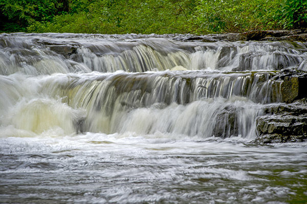
While not big by Upper Peninsula standards, Ocqueoc Falls makes for the perfect place to end a hike or a ride, especially on a hot summer afternoon. The cascade drops 10 feet over a series of three ledges, making it easy in the summer for you to kick off the boots and wade in for a soothing massage of the feet that only Mother Nature could give. The parking lot is just 100 yards or so to the east.

Facilities

At the Ocqueoc Falls day-use area there are vault toilets, a large parking area and a few picnic tables overlooking the falls. Across the road from the trailhead is Ocqueoc Falls State Forest Campground, a rustic facility (hand pump, vault toilets) of 15 sites with many of them situated on a high bank overlooking the Ocqueoc River.

Hours & Fees

The trail is open year round with backcountry skiers and snowshoers using it in the winter. A state park annual or daily vehicle pass is required for the pathway and a nightly fee to stay at Ocqueoc Falls State Forest Campground.

Directions

The day-use area for Ocqueoc Falls is well posted on Ocqueoc Falls Road, which can be reached from Rogers City by following M-68 west for 11.5 miles. When the state highway curves sharply to the south, continue straight onto Ocqueoc Falls Road to the entrance.

Information

The best place for additional information is the DNR Gaylord Regional Office at (989) 732-3541.


Geo-referenced maps from MichiganTrailMaps.com range from $1.99 to $2.99 each.

Download the Avenza app from the App Store or Google Play

App Store Google Play

Michigan TrailMaps.com Michigan's Premier Trail Resource Contact

Trail Mix News

by travel and outdoor writer Jim DuFresne!

Sign Up
Enews Signup
Find a Trail

Find Trails & Maps

Search for Trail
Search by Location
Search by