320

Trails Reviewed

Find Trails & Maps

Search for Trail
Search by Location
Search by

Back to listing

Palmer Woods: Hiking Trails


Buy the Geo-referenced map
for use in the Avenza Maps App

Trail Details

County
Leelanau
Regions
Northwest
Latitude
N 44° 53' 31.20"
Longitude
W 085° 54' 55.80"
Distance
3.8 miles
Trail Type
Foot path, Nordic ski trail
Terrain
Forested ridges
Difficulty
Easy
Nearest City or Town
Glen Arbor
(map loads here)
view map
Avenza Maps
Geo-referenced maps from MichiganTrailMaps.com are available through Avenza Maps and range from $1.99 to $2.99 each.

Download the Avenza app from the App Store or Google Play

App Store Google Play

At more than 1,000 acres, Palmer Woods is by far the Leelanau Conservancy's largest natural area. The Forest Reserve's contiguous hardwood forest stretches more than 2 miles north to south and shares a 5-mile border with the Sleeping Bear Dunes National Lakeshore. Located only a mile from Glen Lake, Palmer Woods is filled with ridges that rise to a high point of almost 1,100 feet. Palmer Woods features 3.8 miles of footpaths,
Expand All
Photos
Description
At more than 1,000 acres, Palmer Woods is by far the Leelanau Conservancy's largest natural area. The Forest Reserve's contiguous hardwood forest stretches more than 2 miles north to south and shares a 5-mile border with the Sleeping Bear Dunes National Lakeshore. Located only a mile from Glen Lake, Palmer Woods is filled with ridges that rise to a high point of almost 1,100 feet.

Preserve namesake Dr. Dan Palmer was responsible for the tract. A dermatologist by trade and a botanist on the weekends with a passion for ferns, Dr. Palmer began purchasing small, undeveloped plots in the early 1970s and accomplished what couldn't possibly be done today. He managed to string together 20 adjoining lots that totaled 750 acres of northern hardwoods in the heart of Leelanau County. In 2013, he offered to sell his woods to the Leelanau Conservancy, which undertook its largest fundraiser, a $3 million campaign.

Palmer Woods is one of the conservancy's two Forest Reserves, the other being Krumwiede located just across Wheeler Road. Both are managed to maintain, even improve, the biological diversity of the trees through periodic selective harvesting. Dr. Palmer was already managing his woods as a sustainable working forest, so the tract is laced by old logging roads with a handful quickly turned into hiking trails. The 2.1-mile Price Valley Trail was the first posted and was followed by the Darwin Loop Trail in 2017. Today there are 3.8 miles of footpaths, and eventually, the forest reserve will feature 9 miles of hiking and skiing trails and more than 15 miles of mountain biking trails.

The conservancy has teamed up with the Friends of Sleeping Bear Dunes to groom a ski trail for both skate and classic skiers when there is sufficient snow. At the same time, snowshoers have also discovered the tract, turning Palmer Woods into a four-season destination for trail users.
Amenities & Services
Difficulty - Easy
Groomed Classic Skiing
Groomed Skate Skiing
Dog Friendly
Trail Guide

Price Valley Trail

The 4-mile hiking trail system is a work in progress and can be accessed from both the north and south end of the forest reserve. From the kiosk on Wheeler Road, there are three options for hikers.

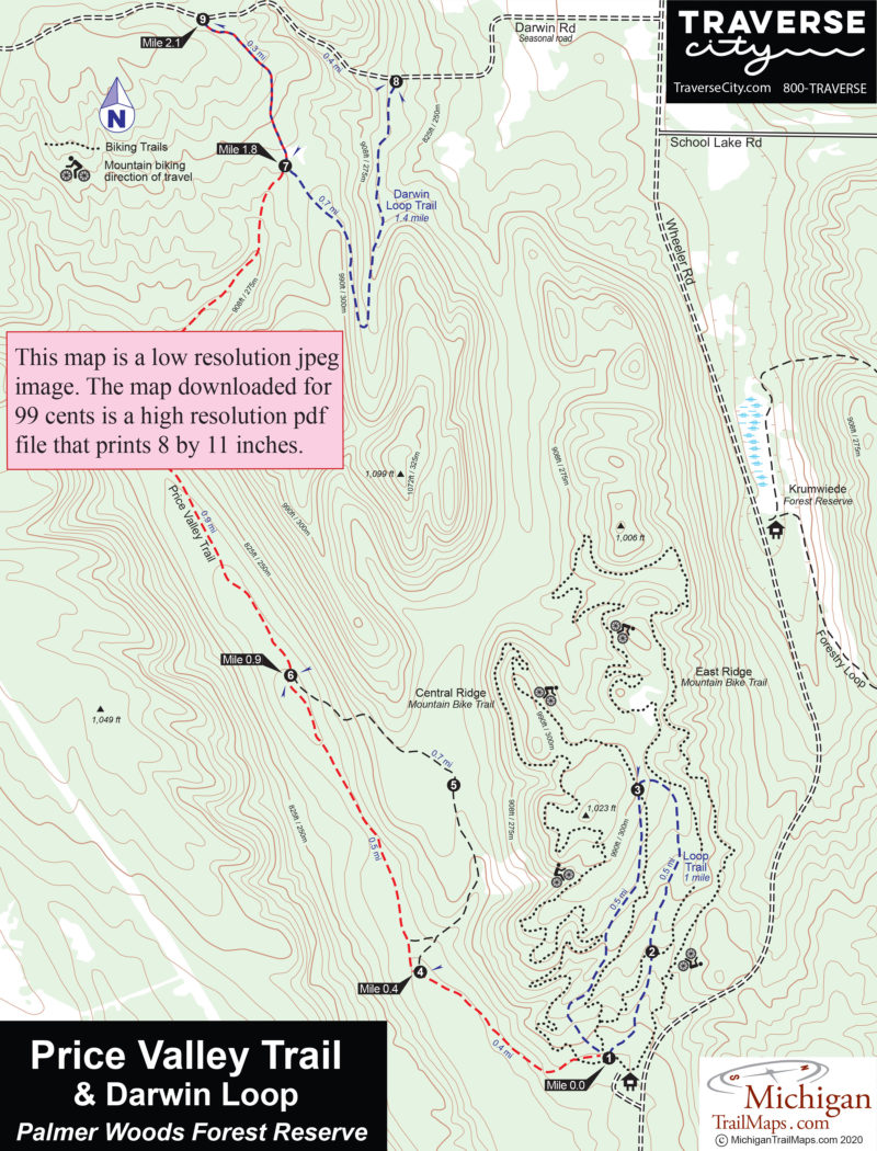
The Price Valley Trail is a 2.1-mile point-to-point hike along a well-defined two-track that ends at Darwin Road, a seasonal road that is not plowed. This is a flat-to-gently rolling trail that is crossed by several old logging trails but is well marked.

From the Wheeler Road trailhead (post No. 1), you head west, quickly cross the Central Ridge Mountain Biking Trail and then swing to the north, passing a 10-foot-high deer enclosure that protects the underbrush and trees from over browsing. You reach post No. 4 at Mile 0.4, where the Price Valley Trail continues to the left.

The two-track remains a level and easy walk between the two ridges for the next 1.5 miles, reaching post No. 6 at Mile 0.9 and post No. 7 at Mile 1.8, where there is another deer enclosure. Price Valley Trail continues north (left), where it steadily climbs to post No. 9, reached at Mile 2.1, and marking the north end at Darwin Road.

If you didn\'t spot a car, you could simply backtrack or follow Darwin Road east to post No. 8 and return to Wheeler Road via the Darwin Loop Trail and then the spur to post No. 5 to avoid as much backtracking as possible, a goal for many of us. Such a hike would total 5.2 miles with the spur to post No. 5 featuring far more climbing than the Price Valley segment.

Darwin Loop Trail

Darwin Loop Trail was added in 2017 when the conservancy purchased an adjoining 14 acres. The trail is actually a 0.7-mile segment between posts No. 8 and No.7, but when combined with the north end of the Price Valley Trail and Darwin Road, it forms a loop of 1.7 miles.

This is a hilly walk in the woods along easy to follow two-tracks. From post No. 8, it\'s a steady climb south of 0.4 miles to the crest of a ridge where at times, it\'s possible to catch a glimpse to the west of Sugarloaf, the shuttered ski resort that closed in 2000. At this point, the trail swings 180-degrees to the north and descends the ridge, reaching post No. 7 at Mile 0.7, marking the junction with the Price Valley Trail.

Head north (right) for a steady, 0.3-mile climb to Darwin Road. You then finish off the loop following the seasonal, dirt road east to post No. 8, reached at Mile 1.7.  The final 0.4-mile segment is a steady descent along a beautiful, winding forested road with usually little to no traffic. Keep in mind the road is not plowed in the winter, and there is limited parking at posts No. 8 and No. 9.

Loop Trail

Also located at the Wheeler Road trailhead is the Loop Trail, a mile-long footpath that lies between the East Ridge and Central Ridge Mountain Bike Trails. Loop Trail is a pair of old two-tracks posted in a counterclockwise direction that begins with a steady, quarter-mile climb to post No. 2. The post marks where the East Ridge Mountain Bike Trail crosses the footpath. You must keep an eye out for off-road cyclists flying downhill here!

The climb continues to post No. 3, reached at Mile 0.5, and marking where Central Ridge Mountain Bike Trail crosses the Loop Trail. At this point, the footpath swings south and begins a steady descent back to the trailhead. For much of the way, you parallel the Central Ridge Trail and can watch mountain bikers racing through the trees.

Facilities

Other than parking an information kiosk at the Wheeler Raod Trailhead, there are no facilities at Palmer Woods Forest Reserve.

Hours & Fees

Palmer Woods is open year-round and features cross-country skiing on groomed trails in the winter. There are no entry or vehicle fees at the preserve.

Directions

From Glen Arbor, head northeast on M-22 and within 6 miles turn south (right) on Wheeler Road. The Palmer Woods trailhead is on the west side of the road, 3.2 miles south of M-22.

Information

For more information, contact the Leelanau Conservancy (231-256-9669; leelanauconservancy.org). For lodging or travel information contact Traverse City Tourism (800-872-8377; www.traversecity.com).


Geo-referenced maps from MichiganTrailMaps.com range from $1.99 to $2.99 each.

Download the Avenza app from the App Store or Google Play

App Store Google Play

Michigan TrailMaps.com Michigan's Premier Trail Resource Contact

Trail Mix News

by travel and outdoor writer Jim DuFresne!

Sign Up
Enews Signup
Find a Trail

Find Trails & Maps

Search for Trail
Search by Location
Search by