320

Trails Reviewed

Find Trails & Maps

Search for Trail
Search by Location
Search by

Back to listing

Pictured Rocks National Lakeshore

Trail Details

County
Alger
Regions
Eastern Upper Peninsula
Latitude
N 46° 27' 11.16"
Longitude
W 086° 36' 21.60"
Distance
0.25 to 42.4 miles
Trail Type
Foot path, Nordic ski trail
Terrain
Sandstone cliffs, Lake Superior, waterfalls
Difficulty
Easy to challenging
Nearest City or Town
Munising
(map loads here)
view map
The towering sandstone cliffs known as the Pictured Rocks rarely fails to impress whoever passes through this far north. First it was Ojibway tribes who would honor the spirits of such a grand creation by leaving behind tobacco. Then French Voyageurs paddling canoes laden with furs and early scholars like Henry Rowe Schoolcraft who in 1820 wrote that the bluffs were some of the most sublime and commanding views in nature.And finally a nation. In 1966, President Lyndon B. Johnson signed landmark legislation that made Pictured Rocks Americas first National Lakeshore. They are that stunning.Towering 200 feet above the worlds largest freshwater lake, the multicolored cliffs extend along 12 o ...
Expand All
Photos
Description
The towering sandstone cliffs known as the Pictured Rocks rarely fails to impress whoever passes through this far north. First it was Ojibway tribes who would honor the spirits of such a grand creation by leaving behind tobacco. Then French Voyageurs paddling canoes laden with furs and early scholars like Henry Rowe Schoolcraft who in 1820 wrote that the bluffs were "some of the most sublime and commanding views in nature."

And finally a nation. In 1966, President Lyndon B. Johnson signed landmark legislation that made Pictured Rocks America's first National Lakeshore. They are that stunning.

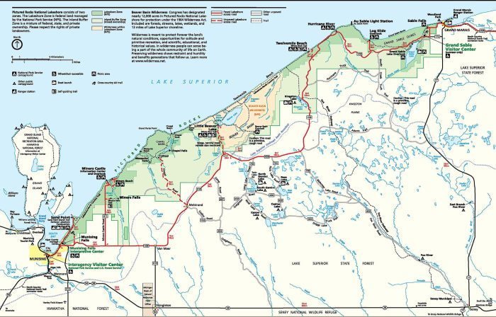
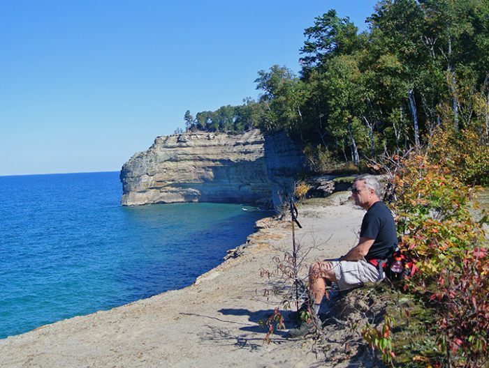
Towering 200 feet above the world’s largest freshwater lake, the multicolored cliffs extend along 12 of the 42 miles of shoreline within the park. The wind, waves and fury of Lake Superior have subsequently sculptured the soft sandstone into caves, arches, pinnacles and pillars with such fine detail they resemble castle turrets, battleships and Indian warriors. Seeping minerals have stained this stone canvas with a palette of  colors; reds and oranges from iron, black from manganese; green from traces of copper, while the sun and the seasons allows you to return again and again and never see the same painting twice.

Where the sandstone escarpment swings inland, miles of unspoiled beaches continue and finally the lakeshore comes to a crescendo with Grand Sable Banks, towering sand dunes perched high above the blue and turquoise-colored waters of Lake Superior. It’s impressive scenery and winding along most of it are foot trails.

For many, the only way to view and appreciate Pictured Rocks’ dramatic scenery is to strap on a pack and hike the 42.4-mile trail that doubles as part of the North Country National Scenic Trail. This is unquestionably one of Michigan’s classic hikes. The trek is a walk between two towns, Grand Marais and Munising, past lighthouses and shipwrecks, giant sand dunes and towering standstone cliffs, beaches on Lake Superior and beaches 200 feet above it. And except for a five-mile stretch from the Grand Sable Visitor Center, the eastern trailhead, you're almost never out of sight of the largest Great Lake of them all.

Other trails that provide opportunities for overnight adventures are the 10-mile Chapel Basin Loop and the 12.9-mile Beaver Lake Loop, both include access to many of the park’s 13 backcountry campgrounds, the only places backcountry camping is allowed.

Pictured Rocks offers a wide range of day hikes as well, ranging from short interpretive trails like the 0.7-mile White Pine Trail at Little Beaver Lake Campground to several trails that lead to the park’s stunning collection of waterfalls. In the winter Nordic skiers, snowshoers, winter campers and ice climbers converge on the park.
Amenities & Services
Camping
Difficulty - Challenging
Difficulty - Easy
Difficulty - Moderate
Foot Path
Groomed Classic Skiing
Trail Guide

To order the Lakeshore Trail Map Click Here.

Click on highlighted trails for individual trail page:

Lakeshore Trail 42.4 miles Backpacking
Chapel Basin Loop 10 miles Backpacking/day hike
Beaver Lake Loop 12.9 miles Backpacking/day hike
Beech Forest Trail 2 miles Short hike
Au Sable Light Station 3 miles Short hike
Miners Falls Trail 1.2 miles Interpretive trail
White Birch Trail 2 miles Interpretive trail
Sable Falls Trail 0.6 mile Short hike
White Pine Trail 0.7 mile Interpretive trail
Sand Point Marsh Trail 0.5 mile Interpretive trail
Log Slide Trail 0.4 mile Interpretive trail
Munising Falls Trail 0.25 mile Short hike
Grand Sable Dunes Trail 1 mile Short hike

Facilities

Pictured Rocks has 13 backcountry campgrounds that are scattered along the Lakeshore Trail at 2 to 5-mile intervals. These 84 sites are the only places backcountry camping is permitted. There are also eight group campgrounds for parties of 7 to 20 people.

A backcountry permit is required for camping and available at the Interagency Visitor Center (906-387-3700) in Munising and from Memorial Day to Labor Day at the Grand Sable Visitor Center (906-494-2660) near Grand Marais. Permits must be obtained in person and are available the day of your trip or one day prior. If arriving after business hours, you must wait until the next day to pick up your permit and then begin your hike. There is a nightly, per-person fee for the permit.

Pictured Rocks also maintains three drive-in campgrounds within the park. Hurricane River is 12 miles west of Grand Marais on H-58 and features 21 rustic sites on two loops. Twelvemile Beach is 15 miles west of Gerand Marais on H-58 and has 36 rustic sites on a bluff overlooking Lake Superior.

Little Beaver Lake is 3 miles north of H-58 and 20 miles northeast of Munising and has eight rustic Reservations are not accepted for the drive-in campgrounds with sites available on a first-come-first-serve basis.

Hours & Fees

The Interagency Visitor Center (906-387-3700) is at 400 East Munising Ave, the junction of state highway M-28 and county road H-58 in Munising is open year round from 9 a.m. to 4:30 p.m. Grand Sable Visitor Center (906-494-2660) is a mile west of Grand Marais on County Road H-58 and open daily from the Friday before Memorial Day through Labor Day from 9 a.m. to 5 p.m. The Munising Falls Visitor Center is on Sand Point Road in Munising and open daily from the Friday before Memorial Day through Labor Day from 9 a.m. to 5 p.m.

Directions

The west entrance of Pictured Rocks National Lakeshore is Munising, a two-hour drive from the Mackinac Bridge via US-2, M-77 and M-28. The east entrance is Grand Marais, 25 miles north of Seney at the end of M-77. In between the two is County Road H-58. The 50-mile road, now fully paved, skirts the boundary of the park providing access to handful of roads that head into its interior.

Information

The best source of information while planning a trip is the Pictured Rocks National Lakeshore website (www.nps.gov/piro) or the Interagency Visitor Center (906-387-3700) in Munising. From Memorial Day to Labor Day the Grand Sable Visitor Center (906-494-2660) near Grand Marais is open.

Files

Geo-referenced maps from MichiganTrailMaps.com range from $1.99 to $2.99 each.

Download the Avenza app from the App Store or Google Play

App Store Google Play

Michigan TrailMaps.com Michigan's Premier Trail Resource Contact

Trail Mix News

by travel and outdoor writer Jim DuFresne!

Sign Up
Enews Signup
Find a Trail

Find Trails & Maps

Search for Trail
Search by Location
Search by