320

Trails Reviewed

Find Trails & Maps

Search for Trail
Search by Location
Search by

Back to listing

Pigeon River Country SF: Pickerel Lake Pathway

Trail Details

County
Otsego
Regions
Northwest
Latitude
N 45° 10' 35.76"
Longitude
W 084° 31' 0.12"
Distance
2-mile loop
Trail Type
Foot path
Terrain
Pickerel Lake, cedar swamp
Difficulty
Easy
Nearest City or Town
Vanderbilt
(map loads here)
view map
Pickerel Lake Pathway is an easy, 2-mile loop that encircles the lake, staying within sight of the water for much of the hike. Although at times you’re hiking through matchstick forests of aspen and even an old clearcut, in the beginning the pathway skirts an interesting cedar swamp and at the north end of the lake winds past pines large enough to make any botanist pause and look up.
Expand All
Photos
Description
Pickerel Lake Road is one of the most interesting roads in the Pigeon River Country State Forest. It departs from the paved Sturgeon Valley Road and climbs through a deep woods before breaking out at a scenic pull-off. Topping off at 1,080 feet is a bench with an impressive view of forested ridges and hills for miles. From there it’s a straight drop down to the Pickerel Lake State Campground that will have anybody riding shotgun gripping the dashboard while you’re worrying about the trailer you’re towing.

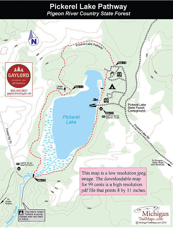
It’s great introduction to this state forest campground. Pickerel Lake is the most popular place to set up camp in Pigeon River Country because it’s the largest facility, featuring the best swimming, some interesting fishing opportunities and serves as the trailhead for the Pickerel Lake Pathway. Combine them all and you have a wonderful destination for the weekend.

Pickerel Lake Pathway is an easy, 2-mile loop that encircles the lake, staying within sight of the water for much of the hike. Although at times you’re hiking through matchstick forests of aspen and even an old clearcut, in the beginning the pathway skirts an interesting cedar swamp and at the north end of the lake winds past pines large enough to make any botanist pause and look up.

Maps often show a trail that connects Pickerel Lake Pathway to Green Timbers but keep in mind that this route is poorly marked and very hard to follow.
Amenities & Services
Camping
Difficulty - Easy
Foot Path
Trail Guide

The pathway is posted on the south side of the boat launch parking area and from there heads around the lake in a clockwise direction. You begin by treading between the stand of cedar that borders the shoreline and a low bluff and in between everything is carpeted in soft green moss.

At Mile 0.4 the pathway merges into an old railroad bed, no doubt left over from the logging days, and then arrives at the foot bridge over Pickerel Creek at Mile 0.5. This is the most scenic corner of the trail as Pickerel Creek flows out of the lake at its marshy south end before heading southwest towards its confluence with the Sturgeon River in Green Timbers. The bridge also marks a junction with a rough trail that follows the creek towards the special, non-motorized tract. It is poorly marked and difficult to follow,

The pathway however is not. The trail crosses the bridge and follows the west side of the lake for a spell, staying within sight the water. At Mile 1.2 you swing into the woods near the north end of the lake and pass a handful of impressive trees, particularly red and white pine. After passing through an old clear cut, you re-enter a more pleasing forest and then pop-out in the campground, across from site No. 13 at Mile 1.8.

Head right and follow the campground road briefly to pick up the trail as it skirts Pickerel Lake and its day-use area before returning to the boat launch at Mile 2.

Facilities

The north shore of Pickerel Lake was a camp for the Civilian Conservation Corps during the 1930s. Today it is a rustic campground with 39 sites, vault toilets and hand pumps for water. There is no beach on the lake but a grassy area serves as one while the water here is shallow for 30 or 40 yards with a sandy bottom. The campground also has an unimproved boat launch with limited parking for a handful of vehicles. Pickerel Lake is completely undeveloped and has a ban on boat motors other than electric.

Hours & Fees

The Pigeon River Country State Forest Headquarters (989-983-4101) is open 8 a.m. to 5 p.m. Monday through Friday. There are no vehicle fees to hike, bike or ski the state forest but there is a nightly fee to stay in the rustic campgrounds.

Directions

From I-75 depart at exit 290 and in the town of Vanderbilt head east on Sturgeon Valley Road. Ten miles from Vanderbilt turn north (left) on Pickerel Lake Road to reach the posted campground entrance in 2 miles.

Information

For additional information stop or call the Pigeon River Country State Forest Headquarters (989-983-4101), an impressive log lodge on Twin Lakes Road.


Geo-referenced maps from MichiganTrailMaps.com range from $1.99 to $2.99 each.

Download the Avenza app from the App Store or Google Play

App Store Google Play

Michigan TrailMaps.com Michigan's Premier Trail Resource Contact

Trail Mix News

by travel and outdoor writer Jim DuFresne!

Sign Up
Enews Signup
Find a Trail

Find Trails & Maps

Search for Trail
Search by Location
Search by