320

Trails Reviewed

Find Trails & Maps

Search for Trail
Search by Location
Search by

Back to listing

Platte River Springs Pathway

Trail Details

County
Benzie
Regions
Northwest
Latitude
N 44° 38' 37.32"
Longitude
W 085° 58' 49.44"
Distance
1.6-mile loop
Trail Type
Day hike
Terrain
Platte River, wooded ridges
Difficulty
Easy
Nearest City or Town
Honor
(map loads here)
view map
Outside of the Porcupine Mountains, there are not too many places in Michigan where you need to ford a stream. But in Benzie County there is Platte River Springs Pathway, a short loop that is packed with adventure, starting with that ford reached minutes after leaving up your car. On the south side of the river the trail winds through 35 acres of rugged bluffs, from which a handful of springs emerge to keep the Platte cold and clear.
Expand All
Photos
Description
Outside of the Porcupine Mountains, there aren’t too many places in Michigan where you need to ford a stream. But here we were, looking at a beautiful stretch of the Platte River with no foot bridge in sight. We were on one side, the trail resumed on the other and the only way to continue was to kick off the hiking boots and splash across the cold trout stream.

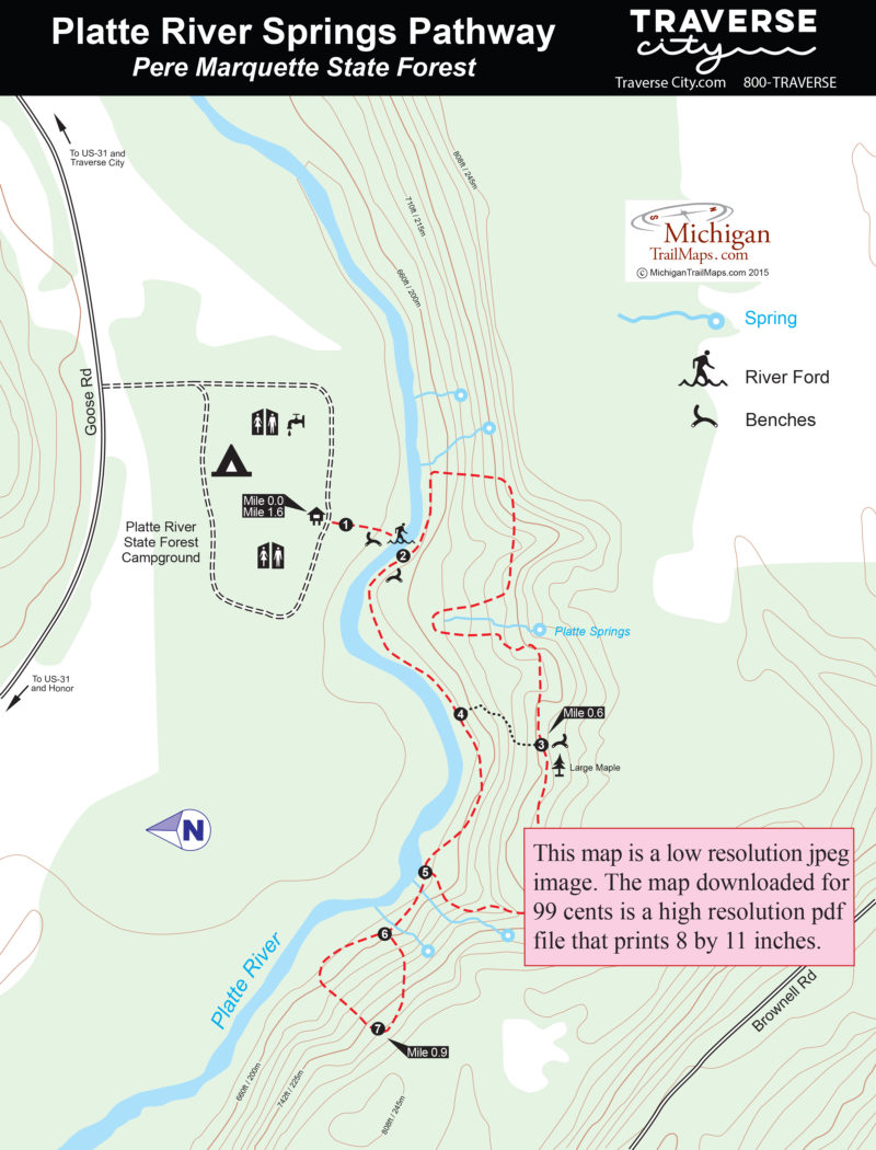
Located in Benzie County, near Honor, the Platte River Springs Pathway is short loop but packed with adventure, starting with that ford reached minutes after leaving up your car. On the south side of the river the trail winds through 35 acres of rugged bluffs, from which a handful of springs emerge to keep the Platte cold and clear. Lining the trail is a handful of towering beech and maples, making this pathway an especially delightful place to hike in the fall.

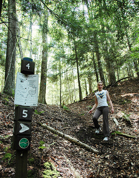
Although rated easy, the route does involve a bit of climbing and path finding. The trail is not easy to distinguish at times, meaning you have to keep a sharp eye out for blue blazes and an occasional trail marker. The entire hike may only be 1.6 miles but the Platte River Springs Pathway is harder than most trails twice its length. Nor is it conducive to mountain biking or cross-country skiing, even if skiers were willing to endure an icy ford in mid-winter.

The pathway begins in the Platte River State Forest Campground and in the fall a wonderful weekend can be spent camping on one side of the river and hiking on the other. In the spring the pathway would be an excellent place to search for morels. At either time of the year, after dashing across the Platte you can warm up the toes with a campfire back at your site.
Amenities & Services
Trail Guide

The pathway is marked on the south side of the campground loop and within 100 yards of the trailhead you arrive at the Platte River. There’s a bench here to kick off your boots or the watery crossing. The trail is easy to spot on the other side where post No. 2 and a another bench is located. You can do the ford in bare feet but there are patches in of stones and mud to contend with. Slipping on a pair of sport scandals is better.

You head upstream briefly and then swing sharply south (right) to scale climb the river bluff along the first of many springs encountered in the area. After topping off the trail descends the ridge and climbs again along a stretch where its easy to wander off course. Follow the blue blazes! Post No. 3 is reached at Mile 0.6 where there is a bernch and just beyond it a huge maple that is stunning in October. The post also marks a cutoff spur down the bluff to post No. 4 though it’s hard to distinguish.

The main trail continues to cling to the steep bluff providing glimpses of the Platte River below between the trees. You pass more giant beech and maples before descending sharply to post No. 5. Head west (left) to cross a pair of springs and follow the separate loop where post No. 7 is located, reached at Mile 0.9 after a another climb up the bluff.

You backtrack to post No. 5 and then follow the trail as its winds through a stand of cedar along the river back to Post No. 2, reached at Mile 1.5. The Platte is so clear that in the summer you watch trout feeding during a hatch and in the fall coho salmon spawning upstream. One more dash across the river and you’re back at the campground.

Facilities

Platte River State Forest Campground is a rustic facility with 26 sites that can accommodate tents and small trailers along with vault toilets and hand pumps for water. The Pere Marquette State Forest campground borders the Platte River but none of the sites are directly on the water.

Hours & Fees

There is a nightly fee to camp at Platte River State Forest Campground but there is no vehicle entry fee to hike the pathway.

Directions

From Honor head east on US-31 and for a mile and then south on Goose Road for 1.5 miles to reach Platte River State forest Campground. The trail is marked along the campground loop.

Information

Contact the Traverse City DNR Field Office (231) 922-5280.

For lodging or travel information contact Traverse City Tourism (800-872-8377; www.traversecity.com).


Geo-referenced maps from MichiganTrailMaps.com range from $1.99 to $2.99 each.

Download the Avenza app from the App Store or Google Play

App Store Google Play

Michigan TrailMaps.com Michigan's Premier Trail Resource Contact

Trail Mix News

by travel and outdoor writer Jim DuFresne!

Sign Up
Enews Signup
Find a Trail

Find Trails & Maps

Search for Trail
Search by Location
Search by