320

Trails Reviewed

Find Trails & Maps

Search for Trail
Search by Location
Search by

Back to listing

Porcupine Mountains: Cross Trail

Trail Details

County
Ontonagon
Regions
Western Upper Peninsula
Latitude
N 46° 46' 1.92"
Longitude
W 089° 53' 7.08"
Distance
4.5 miles
Trail Type
Foot trail
Terrain
Wetlands, old growth forests
Difficulty
Moderate
Nearest City or Town
Ontonagon
(map loads here)
view map
Cross Trail is probably the least traveled route in the park. It connects the Lake Superior Trail at the mouth of the Big Carp River with the Little Carp River Trail near Greenstone Falls. It is a 4.5-mile trek, but most backpackers choose to follow Little Carp River instead, a longer hike (7.3 miles to the Greenstone Falls) but a much more scenic route. Or if they are entering the park, they reach the Big Carp River via Pinkerton and Lake Superior trails, a 4-mile walk.Cross Trail is level for the most part but can be wet, especially in the middle when it crosses Memengwa Swamp, and at times is hard to follow. But since there are usually few people on the trail, chances of spotting wild ...
Expand All
Photos
Description
Cross Trail is probably the least traveled route in the park. It connects the Lake Superior Trail at the mouth of the Big Carp River with the Little Carp River Trail near Greenstone Falls. It is a 4.5-mile trek, but most backpackers choose to follow Little Carp River instead, a longer hike (7.3 miles to the Greenstone Falls) but a much more scenic route. Or if they are entering the park, they reach the Big Carp River via Pinkerton and Lake Superior trails, a 4-mile walk.

Cross Trail is level for the most part but can be wet, especially in the middle when it crosses Memengwa Swamp, and at times is hard to follow. But since there are usually few people on the trail, chances of spotting wildlife are excellent. In most places there will be far more deer tracks in the mud than foot prints and it is rare to hike this trail without seeing at least one set of bear prints.
Amenities & Services
Camping
Difficulty - Moderate
Foot Path
Trail Guide

For a map or complete description to all the trails order Porcupine Mountains Wilderness State Park: A Backcountry Guide for Hikers, Backpackers, Campers & Winter Visitors by Jim DuFresne from the eshop:

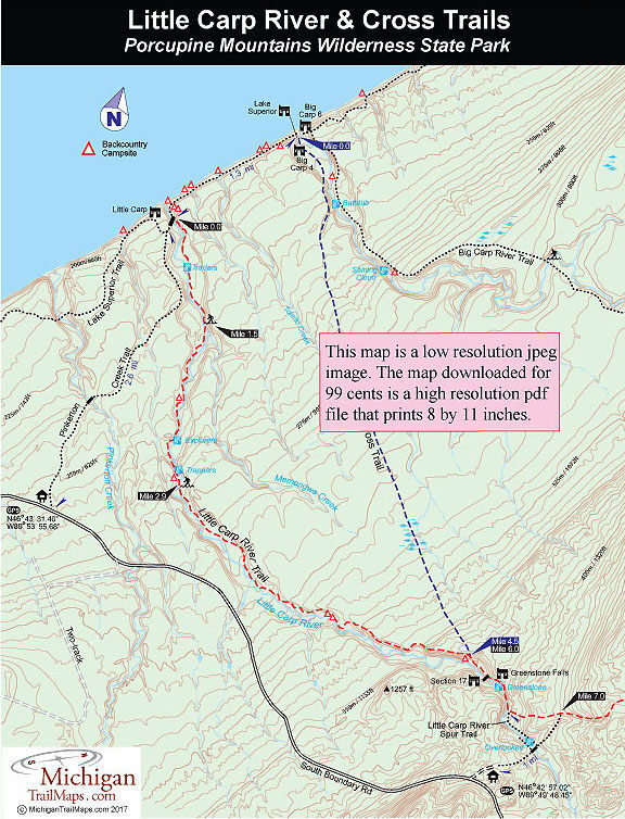
Cross Trail heads south from the posted junction with the Lake Superior Trail on the west bank of the Big Carp River and immediately passes the Big Carp Four Bunk Cabin. The trail stays near the river for the next half mile, winding along a series of interesting pools until you reach Bathtub Falls. At one time this was the start of the Big Carp River Trail and an occasional orange metal blaze might still be embedded in a tree marking where you would have crossed the river.

Cross Trail swings away from the water At this point and makes its steepest climb of the day. You ascend more than 80 feet to the top of a bluff and are rewarded with a fine view of the Big Carp flowing through a series of rapids far below. You follow the river briefly, then the trail swings away from the Big Carp for good, and in a half mile you descend to cross a feeder creek.

Cross Trail then turns into a woods walk through an old growth forest for the next mile and is level with the exception of crossing three streams. The third is Toledo Creek that flows through a small ravine and reached at Mile 2. Toledo Creek is a pleasant forested area for an extended break or lunch as the wet section of the route is only a half mile further along the trail.

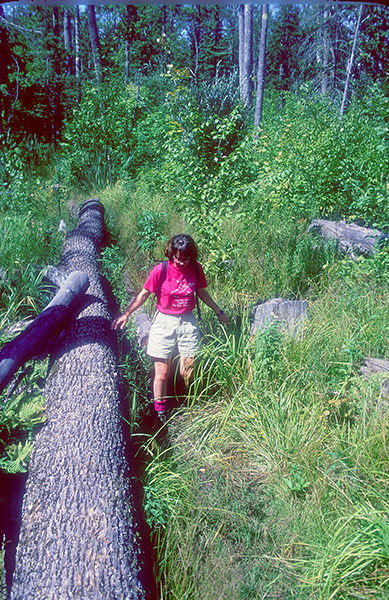
Memengwa Swamp can be sloppy hiking with boot-sucking mud even during a dry spell. It will also be “buggy”, but there is one plus. Wildlife tracks will be all around you. The half-pear prints of whitetail deer will be the most common tracks seen. But look around, if the deer flies will allow it, and there’s a good chance you will spot bear prints. Bear tracks look more like a human foot than they do dog tracks, but they have a larger, more rounded pad and often the claws are clearly visible. Those more than four inches wide indicate a good size bruin has passed through.

Within a half mile the wet lowlying woods turns into a grassy marsh-like opening before Cross Trail returns to the woods. In all, it is roughly a mile of hard slogging before you leave the swamp behind and enter the final portion of the trail, a very gradual ascent through a pleasant stand of hemlock to the high point of 1,221 feet. From here you drop quickly to the Little Carp River Trail junction.

Section 17 Cabin lies just across the river while Greenstone Falls Cabin is a quarter mile to the west. Mirror Lake is a 5.8-miles trek along Little Carp River Trail.

Facilities

There is parking and a toilet at the Little Carp River Trailhead but no source of drinking water.

Hours & Fees

A state park Recreation Passport or daily vehicle permit is required to enter the park and leave a car at the trailhead. Passes can be purchased from the park's Wilderness Visitor Center.

Directions

Cross Trail stretches between Lake Superior Trail at the mouth of the Big Carp River to a junction with the Little Carp River Trail, a mile from the Little Carp River Trailhead on South Boundary Road.

Information

For more information call the park headquarters at (906) 885-5275. You can register for a backcountry campsite or reserve a cabin through the Michigan State Parks Campground Reservation System (800-447-2757; www.midnrreservations.com).


Geo-referenced maps from MichiganTrailMaps.com range from $1.99 to $2.99 each.

Download the Avenza app from the App Store or Google Play

App Store Google Play

Michigan TrailMaps.com Michigan's Premier Trail Resource Contact

Trail Mix News

by travel and outdoor writer Jim DuFresne!

Sign Up
Enews Signup
Find a Trail

Find Trails & Maps

Search for Trail
Search by Location
Search by