For a map or complete description to all the trails order Porcupine Mountains Wilderness State Park: A Backcountry Guide for Hikers, Backpackers, Campers & Winter Visitors by Jim DuFresne from the eshop:

From the parking area, this hike begins as a boardwalk to the overlook and then heads east as a foot path that descends off the high point. In a third of a mile you pass a backcountry campsite and then arrive at the well-posted junction to North Mirror Lake Trail where there is a bench. North Mirror Lake Trail plummets towards Lake of the Clouds, reaching it within a half mile and then continuing another 3.5 miles to Mirror Lake.
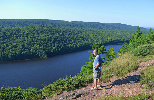
The Escarpment Trail continues with a climb through a mix forest of pines and young oaks. Quickly you arrive at the first overlook, staring down at middle of the lake. The trail resumes with a sharper climb and at Mile 1 you break out at a second vista. This vista is spectacular, as good or better than overlook at the end of M-107 because you’re at much higher at 1,480. At your feet, 400 feet straight down, is Lake of the Clouds in royal blue. To the west you can see visitors who have just stepped out of their cars and to the east is the rest of the Escarpment and the Upper Carp River winding its way into the lake.
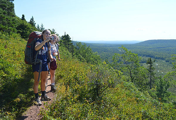
The trail continues along the open cliff for a few hundred yards where you enjoy the scenery every step of the way before dipping into the woods. You cross two small knobs, one with a view, make a rapid descent, and then begin the climb to what on old USGS maps is referred to as Cloud Peak. The trail skirts the 1,514-foot high point, and for the first time in the hike you are standing at the east end of the lake and viewing it in it’s entirely to the west along with the rocky bluff. It is even possible to see a portion of Government Peak on the horizon to the south.
At one time this spectacular view was the only view for most people. Before the Porkies became a state park in 1945, M-107 ended 2 miles short of where it does today, and visitors were faced with a half mile trek to Cloud Peak to see Lake of the Clouds.
From Cloud Peak, the trail makes another rapid descent and reaches the junction with the Cutoff Trail at Mile 2.3. The spur heads north (left) to descend to M-107 in a 0.3 mile and can be used to turn the first half of the Escarpment Trail into a 4-mile loop with a return along the park road. Why anyone would want to return along a paved road with vehicle traffic instead of simply backtracking a foot trail along the Escarpment is beyond me.
To the south (right) is a trail to the site of Carp Lake Mine, a short side trip to see the twin boilers and other remains of the stamping mill. Carp Lake was the name for Lake of the Clouds when the mine was established in 1858. The operation lingered into the 1920s but reached its peak in 1865 when a company of more than 50 men used a small stamping mill to produce 13,000 pounds of copper from several shafts into the Escarpment.
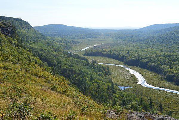
The Escarpment Trail continues straight and immediately begins its ascent to Cuyahoga Peak. You climb more than 200 feet to close in on the 1,604-foot peak and in less than a half mile from the junction you arrive at another panoramic vista, this one centering on the Upper Carp River. Here the trail hugs the edge of the Escarpment while skirting the wooded top of Cuyahoga Peak. At Mile 2.8 is a backcountry campsite. The site is posted and features only a fire ring and enough flat space for one maybe two small tents. But its location is amazing; a mountain-top campsite if there ever was one in Michigan. It’s set back slightly in the trees, yet three steps away is the edge of the rocky bluff where you can sit all night and watch the stars or possibly the Northern Lights reflect off Lake of the Clouds. Return in the morning and you can watch another day begin.
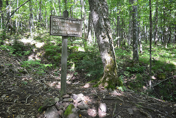
Another open stretch follows then at Mile 3.4 the trail begins the long descent off the Escarpment. You quickly pass the only view of Lake Superior and then begin a steep portion of the descent. The trail levels out briefly to pass Cuyahoga Mine at Mile 4.1, posted with the year “1856.” The mine never produced a profitable amount of copper and probably died out in 1866 when Carp Lake mine was first shut down. All that remains today is a long open, ditch-like trough.
The mine is only a quarter mile from the trail’s east end but it is a steep quarter mile and you’re practically running downhill when you arrive at the junction with Government Peak Trail at Mile 4.3. Head north to reach M-107 in a couple hundred yards and south to stay in the interior of park along Government Peak Trail.