For a map or complete description to all the trails order Porcupine Mountains Wilderness State Park: A Backcountry Guide for Hikers, Backpackers, Campers & Winter Visitors by Jim DuFresne from the eshop:
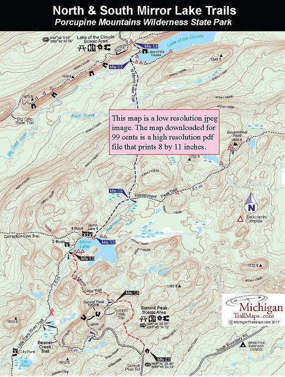
South Mirror Trail
Distance: 3 miles to Mirror Lake
A trailhead with limited parking is located a little more than a mile up Summit Peak Road. If the parking area is full, a larger one for overflow is located at the beginning of the road. The trail departs north from here as a forest road that is used off-season by the staff as a service drive into the heart of the park.
You climb more than 200 feet from the trailhead, topping off at 1,730 feet within a half mile. At this point the trail begins to skirt the Summit Peak ridge. At 1,958 feet, Summit Peak is the highest point in the park and third highest in the state. Eventually the trail descends the ridge and quickly arrives at a posted junction with the Summit Peak Trail at Mile 1.5. The view from the peak is nice, but it is a steep, 240-foot climb to the top from here.
South Mirror Lake Trail continues north as a forest road descending gently until it bottoms out at small stream at Mile 2 where nearby is a bench. The old logging road continues straight but South Mirror Lake Trail, now a true foot path, veers to north and at Mile 1.8 climbs to 1,650 feet, crosses the ridge and then descends to the Little Carp River. Just before crossing the river, you pass the spur that leads to three backcountry campsites located on a long inlet that forms the west end of the lake. The campsites are just a 100 yards from the trail and feature fire rings and tent pads overlooking the lake. Needless to say they are extremely popular.
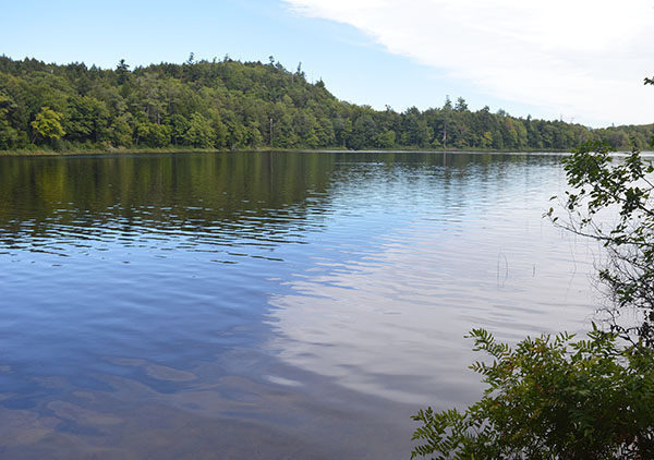
A foot bridge crosses Little Carp River and on the other side, at Mile 3, is the posted junction with Little Carp River Trail. From here Lily Pond is 2.3 miles to the west and the three cabins on the north side are a half mile to the east. At 1,538 feet, Mirror Lake is the highest lake in the park and one of the highest in the state. It is surrounded by rugged bluffs and ridges, many which can be climbed
for views of the area, while old growth white pine dominates much of the shoreline. The trail skirts the lake, first passing a spur to the Two-Bunk Cabin and later a posted junction to Correction Line Trail.
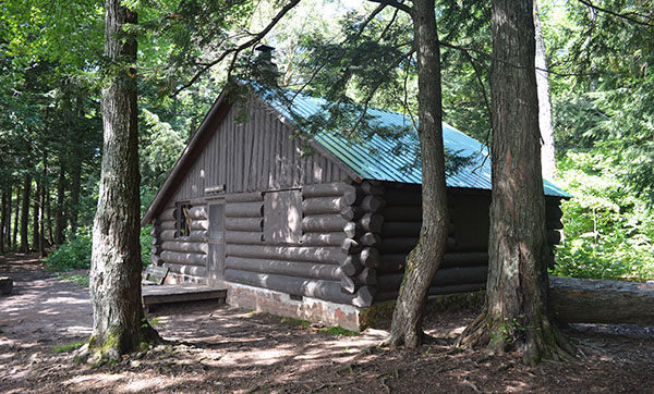
Just beyond the junction is the Four-Bunk Cabin located near the lake in a stand of towering pine. Finally, you reach the Eight-Bunk Cabin, a virtual log lodge perched right above the water. You need to continue along the trail past the large cabin to pick up the North Mirror Lake Trail or reach three more backcountry campsites along the east side of the lake.
North Mirror Lake Trail
Distances: 0.9 mile to Government Peak Trail
3.3 miles to Lake of the Clouds
North Mirror Lake Trail extends from the lake to the Lake of the Clouds Overlook, a 3.8-mile trek that takes most hikers almost good three hours to walk. From the shoreline, the North Mirror Lake quickly crosses a creek and then parallels Trail Creek as it climbs a low ridge. This section is often wet and muddy from heavy use even though you are well above the creek. At Mile 0.9 you come to the posted junction with the Government Peak Trail.
Government Peak heads east to reach the 1850-foot high point in 2.1 miles. North Mirror Lake Trail departs the junction to the north and begins a gentle ascent while in a mile you top off at 1640 feet. This stretch can also be muddy at times but scenic in October when the fallen leaves give way to views of 1700-foot ridges on both sides of you. Nearby is a backcountry campsite.
Beyond the ridges, the trail begins a long descent, easy walking at first, but 2 miles from the lake the trek becomes a knee-bending drop. If coming from the Lake of the Clouds Overlook, you will find this is one of the steepest climbs in the park. In 0.75 mile, you descend from 1,640 feet to 1,160 through a gorge-like area where a tributary of Scott Creek rushes downhill. Keep your eyes peeled for trail blazes in the trees as it's easy to get turned around here.
You bottom out to cross Scott Creek, climb over a 1,200-foot ridge and at Mile 3.3 arrive at the west end of Lake of the Clouds. A spur heads left to a series of four backcountry campsites. A long boardwalk crosses a stream emptying into the lake here and makes for a unique viewing point. You can not see much of the famous lake but you can look above to spot people staring down at you from the Lake of the Clouds Overlook.
The trail swings to the east, passes a backcountry campsite along the shoreline of the lake and then comes to the spur that leads to the Lake of Cloud Cabin a quarter mile away. The final half mile is a steep march uphill as the trail becomes a series of switchbacks, gaining more than 150 feet from the level of the lake until finally breaking out at the M-107 parking lot at 1,340 feet. Along the way you pass a posted junction to west end of the Escarpment Trail.