320

Trails Reviewed

Find Trails & Maps

Search for Trail
Search by Location
Search by

Back to listing

Porcupine Mountains: Union Mine Trail

Trail Details

County
Ontonagon
Regions
Western Upper Peninsula
Latitude
N 46° 47' 38.40"
Longitude
W 089° 37' 37.56"
Distance
1.1-mile loop
Trail Type
Interpretive Trail
Terrain
Little Union River Gorge
Difficulty
Easy to Moderate
Nearest City or Town
Ontonagon
(map loads here)
view map
When the water is up or during spring runoff, there is no finer trail for waterfall lovers than the Union Mine Trail. But its a great walk any time of the year for those intrigued by the copper mining history of the Porcupine Mountains. One of two interpretive trails in the park, Union Mines originally featured 14 numbered posts that correspond to an informative brochure, a brochure that by July was often out at the trailhead parking lot. The park has since replaced the posts with 10 interpretive plaques that feature more text and photos. In short, more colorful mining stories and history.Union Mine is only a 1.1-mile loop but it descends 100 feet in the beginning, meaning you need to cl ...
Expand All
Photos
Description
When the water is up or during spring runoff, there is no finer trail for waterfall lovers than the Union Mine Trail. But it’s a great walk any time of the year for those intrigued by the copper mining history of the Porcupine Mountains. One of two interpretive trails in the park, Union Mine’s originally featured 14 numbered posts that correspond to an informative brochure, a brochure that by July was often out at the trailhead parking lot. The park has since replaced the posts with 10 interpretive plaques that feature more text and photos. In short, more colorful mining stories and history.

Union Mine is only a 1.1-mile loop but it descends 100 feet in the beginning, meaning you need to climb a 100 feet out at the end. You also have to be conscious of roots and rocks embedded in the path and keep in the mind that the many cascades here are far less impressive during low water periods of late summer and fall.
Amenities & Services
Camping
Difficulty - Easy
Foot Path
Trail Guide

For a map or complete description to all the trails order Porcupine Mountains Wilderness State Park: A Backcountry Guide for Hikers, Backpackers, Campers & Winter Visitors by Jim DuFresne from the eshop:

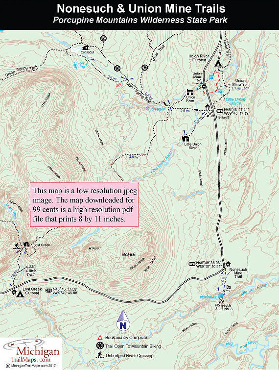
The trailhead is marked by a giant shovel stuck in the ground and from there you depart from the north side of the parking lot to hike the trail in a clockwise direction. Within a 100 yards the trail swings sharply east (right) and descends to the Union River. You bottom out where “trap rock,” highly sought after by miners because it usually indicated copper deposits, encloses the scenic gorge on the opposite bank. The trail skirts the river and at Mile 0.2 you arrive at a bench and the location of the Union Mine’s waterwheel. Take a seat and let the waterfalls below sooth you.

The location of the first Union Mine, a collapsed tunnel, follows and at Mile 0.3 you cross South Boundary Road. The trail passes the foundation of mine’s stamp mill and then skirts a small bluff where below the Union River tumbles through more waterfalls that includes a bench overlooking one at Mile 0.5. Just down the trail you reach a junction that leads to River Trail, the winter cross-country route, and the bridge to Union River Outpost. Here Union Mine Trail swings south, following the original Nonesuch Road for a spell, to cut across to Little Union River Gorge.

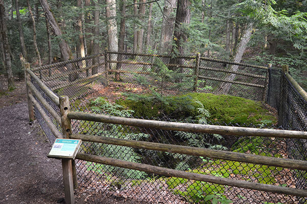
From the historic road a climb of 30 steps leads to a massive hemlock where the trail swings west to follow Little Union River upstream. You past another bench with a long view of the cascades in the gorge below and then arrive at the fenced-in shaft of the Boston & North American Mining Company at Mile 0.8. The trail continues along the edge of the shady cleft, passing one cascade after another with a bench overlooking Little Union Falls near Mile 1.

In the final leg, you climb out of Little Union Gorge, cross South Boundary Road a second time and swing north to quickly arrive back at the trailhead parking area.

Facilities

Union River Outpost Campground is near the Union Mine Trailhead on the opposite side of South Boundary Road and has three rustic campsites and a vault toilet. There is no source of safe drinking water in the campground or at the trailhead.

Hours & Fees

A state park Recreation Passport or daily vehicle permit is required to enter the park and leave a car at the trailhead. Passes can be purchased from the park's Wilderness Visitor Center. A site at Union River Outpost is $15 a night.

Directions

Union Mine Trail is 1.7 miles south of M-107 on west side of South Boundary Road.

Information

For more information call the park headquarters at (906) 885-5275.


Geo-referenced maps from MichiganTrailMaps.com range from $1.99 to $2.99 each.

Download the Avenza app from the App Store or Google Play

App Store Google Play

Michigan TrailMaps.com Michigan's Premier Trail Resource Contact

Trail Mix News

by travel and outdoor writer Jim DuFresne!

Sign Up
Enews Signup
Find a Trail

Find Trails & Maps

Search for Trail
Search by Location
Search by