For a map or complete description to the Union Spring Trail order Porcupine Mountains Wilderness State Park: A Backcountry Guide for Hikers, Backpackers, Campers &Winter Visitors by Jim DuFresne from the eshop:
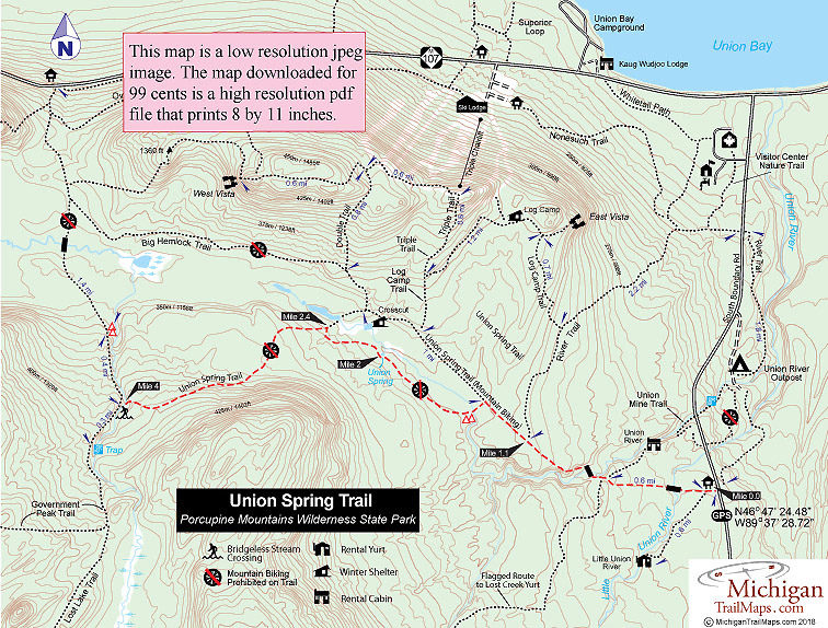
Union Spring Trail begins on an old logging road that at crosses a bridge over Little Union River and and at Mile 0.6 reaches the spur to the Union River Cabin. Available year-round and a favorite with backcountry skiers in the winter, Union River overlooks its namesake river and is a scenic and secluded spot despite being only a 0.3 mile from the main trail.
From the cabin spur, Union Spring s Trail immediately passes the posted junction with the winter flagged route to the Lost Creek Yurt and descends to cross a bridge over Union River. You make a short ascent out of the river gorge, the only climb on the way to the spring. At Mile 1.1 you pass the junction with River Trail, part of the park’s groomed ski and mountain bike trail system, and within 0.3 mile reach the site of the old impoundment and where Union Springs Trail splits.
The old logging trail continues northwest (right) at the junction and is groomed in the winter for Nordic skiers and open to mountain bikers the rest of the year. To the south is the route to Union Springs, a foot path that is closed to mountain biking.
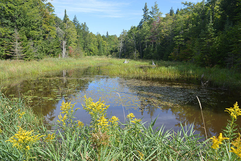
The impoundment is now a large meadow, ideal for wildlife watching while the campsites, consisting of two tent pads and fire rings, are tucked into the forest nearby for a bit of privacy. Union Spring itself is another half mile along a level route through stands of old growth hardwoods and hemlock.
The route can be wet at times but the surrounding forest is impressive. Union Spring is reached at Mile 2 and appears as a small pond with a viewing platform extending out to the middle of it. From the end of the platform, you can gaze into the deep but clear pool to see the spring bubbling out of the ground at more than 700 gallons a minute.
The spring marks the halfway point to Government Peak Trail and the remaining 2 miles begin in a low-lying, marshy area, a good place to spot wildlife. A bad place to be without bug dope. At Mile 2.4 you reach a junction where the two segments of the Union Spring Trail merge into one. The trail north (right) extends a quarter mile to the junction with Double Trail that climbs the backside of the downhill ski area.
At this point Union Spring Trail heads west (left) and begins climbing to the high elevation of Government Peak Trail and the Upper Carp River. You actually top off at 1,320 feet and from there descend quickly into the Upper Carp River Gorge. At the river itself an easy ford puts you on the west bank at the junction with Government Peak Trail. Head north along this trail to reach a pair of scenic backcountry campsites in a 0.4 mile and M-107 in 1.8 miles. Head south to reach Trap Falls in less than a 0.3 mile.