320

Trails Reviewed

Find Trails & Maps

Search for Trail
Search by Location
Search by

Back to listing

Portage Point Woods Preserve

Trail Details

County
Manistee
Regions
Northwest
Latitude
N 44° 22' 59.52"
Longitude
W 086° 14' 35.52"
Distance
1.8 miles
Trail Type
Foot path
Terrain
Forested ridges and back-dunes
Difficulty
Easy
Nearest City or Town
Onekama
(map loads here)
view map
Established in 2013, Portage Point Woods Preserve is a 120-acre tract located in Manistee County and within a quarter mile of the Nature Conservancy’s oldest preserve; Lucia K. Tower. For most visitors Portage Point Woods is a 1.8-mile loop between the two trailheads highlighted by ridge walks beneath the impressive trees on the crest of its back-dunes. There is a bit of climbing but overall this is an easy outing that allows you to enjoy the magnificent timber above you.
Expand All
Photos
Description
Established in 2013, Portage Point Woods Preserve is a 120-acre tract located in Manistee County and within a quarter mile of the Nature Conservancy’s oldest preserve (1974), Lucia K. Tower. The 23-acre Tower Preserve protects a swath of the Portage Point Dunes that includes a stunning, wind-swept blowout rising 200 feet above Lake Michigan.

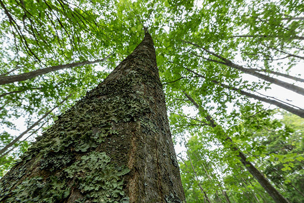
Portage Point Woods, on the other hand, is a series of forested back-dunes that shelter inland areas from the erosion process of the Great Lake winds and sand deposits that are seen so dramatically at Tower Preserve. There is no open sand at Portage Point. What captivates you are the mature hardwoods of sugar maples, American beech, basswood, red oaks and even Eastern hemlocks that now cover the ridges.

In the fall, when the back-dunes are saturated in a wide array of autumn colors, Portage Point Woods is at it's best. In the spring, the colors are softer as these stately hardwoods provide habitat for wildflowers such as trillium, hepatica, jack-in-the-pulpit, spring beauty, dwarf ginseng and bloodroot. In the summer, they are shelter from the sun.

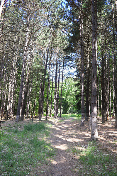
Portage Point Woods features 1.6 miles of maintained footpaths along with a handful of overgrown two-tracks and social trails. The trail system is well marked, however, keeping hikers or snowshoers from getting turned around. The main trailhead is on Herkelrath Road and includes a parking area and an interpretive kiosk.

For most visitors, Portage Point Woods is a 1.8-mile loop between the two trailheads highlighted by a ridge walk beneath the impressive trees of the back-dunes. There is a bit of climbing, but overall this is an easy outing that allows you to enjoy the magnificent timber above you.
Amenities & Services
Difficulty - Easy
Foot Path
Trail Guide

This hike is described in a counterclockwise direction, beginning with the Red Trail and saving the most interesting portion of the loop, the Blue Trail,  for the end. From the Herkelrath Road trailhead, you immediately enter a somewhat sterile stand of red pines but at the return junction are blessed with the rolling terrain that are back-dunes and more interesting trees.

In the next half mile, Red Trail passes a handful of overgrown two-tracks. Some are very distinguishable, others you’ll miss. The trail, however, is well marked and easy to spot. At Mile 0.6 you pass an old two-track on the left and then make the steepest climb of the day topping off at the junction with the Blue Trail.  Continue west along another back-dune. You descend and then use a stairway to climb again and pop out at the Ivanhoe Road trailhead at Mile 0.9.

The loop continues by backtracking to the Blue Trail junction and heading south. This is the most interesting ridge of the day, featuring steep drop-offs on each side of the trail and the most impressive trees. At Mile 1.3 the trail squeezes between a pair of towering Eastern hemlocks and then a little further south passes a massive oak on the left. You descend off the ridge at this point and then swing sharply to the east where there are overgrown two-tracks heading off in both directions. The first junction of the day is reached at Mile 1.7. The Herkelrath Road trailhead is just beyond it.

Facilities

The main trailhead is on Herkelrath Road and includes a parking area and an interpretive kiosk. A second trailhead with limited parking is on the west side of the preserve along Ivanhoe Road.

Hours & Fees

The preserve is open year-round and there are no vehicle or entry fees.

Directions

From Onekama head north for a mile on M-22 and then turn west onto Portage Point Drive for 1.8 miles. Turn north onto Herkelrath Road and within a quarter mile the preserve is posted on the west side of the road.

Information

Contact the Michigan Chapter of The Nature Conservancy (517-316-0300; email: michigan@tnc.org).


Geo-referenced maps from MichiganTrailMaps.com range from $1.99 to $2.99 each.

Download the Avenza app from the App Store or Google Play

App Store Google Play

Michigan TrailMaps.com Michigan's Premier Trail Resource Contact

Trail Mix News

by travel and outdoor writer Jim DuFresne!

Sign Up
Enews Signup
Find a Trail

Find Trails & Maps

Search for Trail
Search by Location
Search by