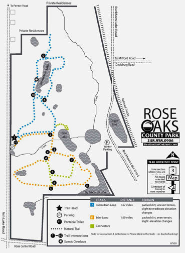
Rose Oaks County Park

Trail Details
The northwest corner of Oakland County is rural horse country, an area of rolling pastures, whitewashed fences, faded red barns and mares and foals trotting through open meadows. In the middle of it is Rose Oaks County Park, the reason its trail system is open to horseback riding and probably used more by equestrians than hikers.
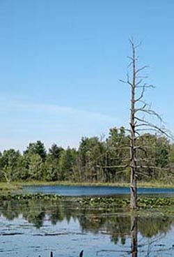
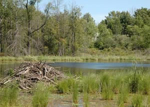
The 637-acre park was purchased by the county 1995 to become its 11th park. Its terrain includes wooded uplands and gently rolling open meadows. But it’s dominated by wetlands and a series of small glacially-created lakes. Almost a third of Rose Oaks, some 200 acres, is marshes and vast cattail swamps that surround two creeks and almost a dozen ponds and lakes. Needless to say, insects can be ferocious here, particularly deer flies in July. Wildlife includes whitetail deer, waterfowl, a variety of woodland birds and beavers who have set up lodges on the lakes.
The park’s trail system totals 4 miles and is a pair loops with the 1.67-mile Richardson Loop skirting its namesake lake to the north and the 1.69-mile Esler Loop in the southern half of the park. Trail surface ranges from old two-tracks and heavily graveled stretches to mowed lanes through open meadows and are well marked with maps at most junctions. Because of the heavy equestrian use some sections will be muddy but overall the trails keep your boots dry despite the wetlands and ponds you’ll be hiking around. Mountain bikers are prohibited from riding on the trails.
The most interesting walk is the Richardson Loop where you hike through the oak and maple forests and around the lake, the largest within the park. Hiking Richardson Loop along with a short side trip to Esler Lake is a hair over 2 miles. The perimeter of the entire trail system is a 3.5-mile walk.
| Difficulty - Easy |
| Foot Path |
Geo-referenced maps from MichiganTrailMaps.com range from $1.99 to $2.99 each.
Download the Avenza app from the App Store or Google Play


