Rosy Mound Natural Area

Buy the $.99 downloadable map!
(This map is not geo-referenced)Trail Details

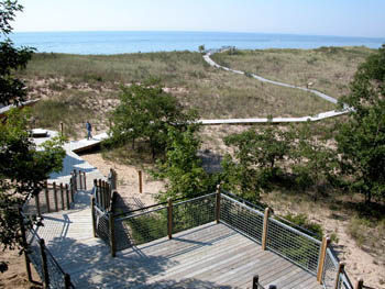
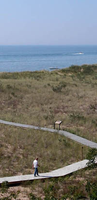

You're on the edge of Grand Haven yet the only man-made object you can see is a boardwalk across the sand.
Despite a history of logging, sand mining and uncontrolled recreational use, this park appears as natural and pristine as if you were standing in a remote corner of Sleeping Bear Dunes.
Dedicated in 2004, the 164-acre natural area is one of Michigan's newest tract of protected dunes, a $1.1 million effort by Ottawa County to not only save the sensitive ecosystem but to shield and protect it from future visitors.
Access into Rosy Mound is strictly on foot and all the trails are either boardwalks, cement or compacted, crushed stone. Lining the trails are signs asking you not to wander off them. Nor are dogs allowed in the park. The strategy is simple; concentrate park users on a hardened, erosion-resistant surface until they reach the beach.
The nearly 200-foot dune that dominates the park is Rosy Mound. Allegedly the dune was named by either early settlers who found the top of it covered with wild roses or by Native Americans for the rosy hue cast on the dune at sunset.
What is known is that the area was heavily logged in the late 1800s and again in the early 1900s, a time when Grand Haven alone boosted eight saw mills. By 1924 a company was mining the dune, shipping the sand to foundries throughout the Midwest.
Interest in preserving the tract began in the 1960s when the students of nearby Rosy Mound Elementary School appealed to Senator Phillip Hart. By 1989 acquiring Rosy Mound was a priority of the Department of Natural Resources and a newly formed Ottawa County Parks and Recreation Commission. The state finally purchased the area in 1994 and in 2003 deeded it to the county. By then it had become an unregulated playground with a mishmash of trails causing serious erosion.
The park's infrastructure required a year to build and involved helicopters ferrying in wood and buskets of cement to avoid damaging the dunes. Workers meanwhile were transplanting endangered Pitcher's thistle from the construction areas. When the park officially opened the only way for visitors to reach the beach was by hiking over Rosy Mound.
| Difficulty - Challenging |
| Foot Path |
Geo-referenced maps from MichiganTrailMaps.com range from $1.99 to $2.99 each.
Download the Avenza app from the App Store or Google Play


