320

Trails Reviewed

Find Trails & Maps

Search for Trail
Search by Location
Search by

Back to listing

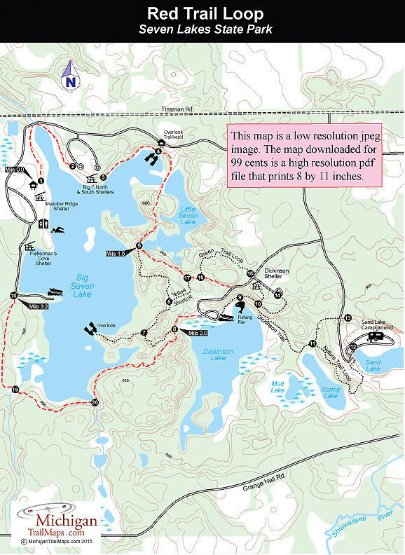
Seven Lakes State Park: Red Trail Loop

Trail Details

County
Oakland
Regions
Southeast
Latitude
N 42° 48' 58.32"
Longitude
W 083° 40' 46.20"
Distance
3.8-mile loop
Trail Type
Hike and bike trails
Terrain
Inland lakes, wetlands, hardwood hills
Difficulty
Moderate
Nearest City or Town
Holly
(map loads here)
view map
The park considers the Red Trail Loop to be a 1.8-mile, one-way route from Meadow Ridge Shelter on Big Seven Lake to the Dickinson Boat Launch. But a more logical hike would be to continue on the Green Trail Loop a short distance and then depart at post No. 8 to skirt the south end of Big Seven Lake, looping back to the picnic area and beach along its west shore.This would be a 3.8-mile hike that would eliminate any backtracking while skirting the parks three-largest lakes and covering some of the most scenic sections of its trail system.
Expand All
Photos
Description
The park considers the Red Trail Loop to be a 1.8-mile, one-way route from Meadow Ridge Shelter on Big Seven Lake to the Dickinson Boat Launch. But a more logical hike would be to continue on the Green Trail Loop a short distance and then depart at post No. 8 to skirt the south end of Big Seven Lake, looping back to the picnic area and beach along its west shore.

This would be a 3.8-mile hike that would eliminate any backtracking while skirting the park’s three-largest lakes and covering some of the most scenic sections of its trail system.
Amenities & Services
Camping
Difficulty - Moderate
Dog Friendly
Multi-use Trail
Trail Guide

The trailhead for the Red Trail Loop is post No. 1 near the Meadow Ridge Shelter on the west side of Big Seven Lake. From there it heads north along an open grassy shoreline with views of the park’s largest lake. Within a quarter of a mile you dip to the park road to cross a dam and small stream and then return to the foot path, arriving at post No. 2 in a picnic area.

At the Big Seven North Shelter the trail is marked by post No. 3 and enters the woods and then climbs a ridge before popping out at the Overlook parking lot. Located here is a bench with a view of the lake and interpretive display on the state park. The trail descends a grassy slope to the east and soon you’re crossing the spillway and earthen dam hat separates Big Seven Lake and Little Seven Lake. There are views of water on both sides of you while straight ahead you can see where the trail re-enters the woods.

At Mile 1.5 you arrive at post No. 5 where the Red Trail Loop merges with the Green Trail Loop at the south end of Little Seven Lake. Head east (left) and within a quarter mile you’ll be at post No. 16 where the Red Trail Loop splits off south (right) to quickly reach the boat launch.

To continue around Big Seven Lake pick up the Green Trail Loop and follow it west a quarter mile from the boat launch parking lot. At post No. 8 head south (left) as the trail skirts the south end of the lake. You move from tracts of mature hardwoods to second growth forests and cross a pair of small streams, marked by posts, before breaking out at post No. 18 near the park road on the west side of the lake at Mile 3.2. Head north (left) to follow the park road to the large beach and day-use area and then cut through it to return to Meadow Ridge Shelter.

Facilities

Seven Lakes features a 70-site, modern campground that overlooks Sand Lake in the southeast corner of the park. Sand Lake used to be a gravel pit at one time so the campground is an open grassy area in a partially wooded bowl. There's a swimming area on the lake and a trail that connects the campground to Spring Lake, a walk-in lake that can be fished for bluegills and bass.

On the west side of Big Seven Lake, the park maintains a beach and picnic area, which includes a bathhouse, designated swimming area, tables and grills. There is also a boat rental concession open daily during the summer. Boats for rent include canoes, rowboats and paddleboats. On the north end there is a picnic area with tables, grills and two shelters on a hill with a view of most of the lake. There is also a picnic area off the road to Dickinson Road with a shelter that the Green Trail passes through.

Hours & Fees

The park is open year round and a vehicle permit or annual state park pass is required to enter.

Directions

The park is a mile west of Holly with an entrance off Fish Lake Road, just north of Grange Hall Road. From 1-75, depart at exit 101 and head west on Grange Hall Road. Within four miles turn north on Fish Lake Road to reach the park entrance in a mile.

Information

Call the park at (248) 634-7271. For a campsite contact Michigan State Park Central Reservations(800-447-2757; www.midnrreservations.com).


Geo-referenced maps from MichiganTrailMaps.com range from $1.99 to $2.99 each.

Download the Avenza app from the App Store or Google Play

App Store Google Play

Michigan TrailMaps.com Michigan's Premier Trail Resource Contact

Trail Mix News

by travel and outdoor writer Jim DuFresne!

Sign Up
Enews Signup
Find a Trail

Find Trails & Maps

Search for Trail
Search by Location
Search by