Shiawassee Wildlife Refuge: Woodland Trail
Buy the $.99 downloadable map!
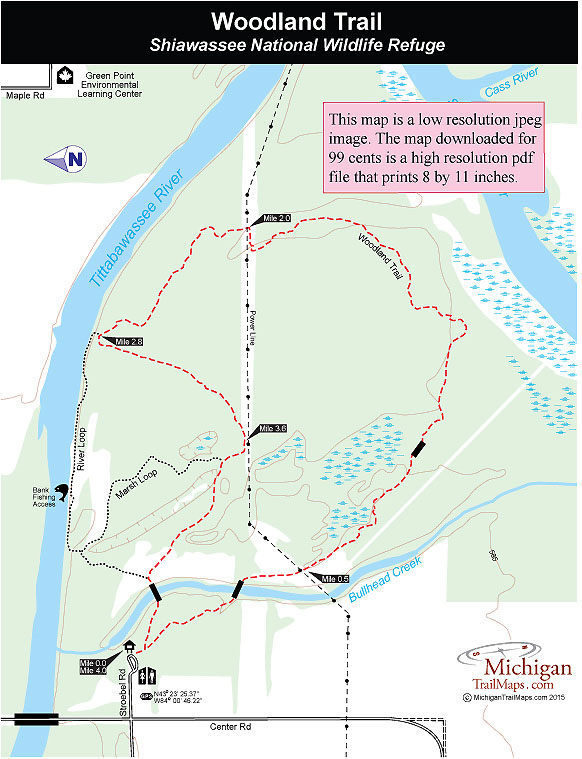
(This map is not geo-referenced)Trail Details


Woodland Trail may be part of Shiawassee National Wildlife Refuge but it is literally on the edge of a city and Saginaw is lucky because of that. If there was ever a perfect escape from its urban grasp, this is it; a point of land where two great rivers converge to form a moat against the advances of what some people would call progress and others decay. On the north there's the Tittabawassee, on the south side the Shiawassee. In between the two is an area of woods, marshes, creeks and 5 miles of trails open to hikers, mountain bikers and cross-country skiers.
The trail system is divided into three loops of various lengths that all begin from the same trailhead. The Marsh Loop is the shortest, a mile-long loop in the woods. The River Loop is 2 miles and includes a half mile stretch that passes through a field along the bank of the Tittabawassee River.
Woodland Trail is the longest loop at 4 miles and true to its name stays primarily in the bottomland forest with only a passing glimpse of the Tittabawassee River and none of the Shiawassee River. It would be easy to add the scenic stretch of the River Loop to the Woodland Trail. That would reduce the length of the route to 3.6 miles but in doing so you would miss one of the most interesting stretches of the Woodland Trail. What to do? Ride or hike them both for a 6-mile outing.
Unlike the Ferguson Bayou Trail on the south side of the Shiawassee River, the Woodland Trail is a narrow primitive path rather than utilize a series of dikes. But overall the trails are level and easy and surprisingly dry considering the swamps and ponds they pass. They are ideal for beginner mountain bikers and are popular in the winter with cross-country skiers when there is sufficient snowfall.
Keep in mind that this area is a floodplain prone to excessive seasonal flooding and wetness, particularly in the spring. The bugs can also be thick here in early summer.
To reach the trail depart I-75 at exit 149 and head west on M-46 for almost 7 miles, crossing the Saginaw River along the way. Turn south (left) on Center Road and in 1.7 miles you’ll cross the Tittabawassee River and then see a sign for the refuge trail on the east side of the road. The parking lot and trailhead is just off Center Road.
| Difficulty - Moderate |
| Mountain Bike Single Track |
| Multi-use Trail |
Geo-referenced maps from MichiganTrailMaps.com range from $1.99 to $2.99 each.
Download the Avenza app from the App Store or Google Play


