Silver Lake State Park

Buy the $.99 downloadable map!
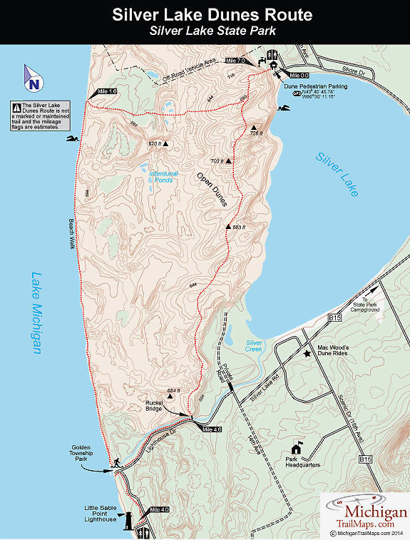
(This map is not geo-referenced)Trail Details
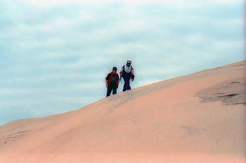

Perched on a plateau and rising more than 100 feet high above Silver Lake, the heart of these dunes are totally devoid of any vegetation, even dune grass. The only thing besides sand are the stumps and trunks of ghost forests, ancient trees that the migrating dunes had buried and killed. Almost half of the hike is in this Sahara Desert-like terrain, the other half is spent strolling a stretch of Lake Michigan that is free of cottages and frozen custard stands.
A rare hike indeed.
In all Silver Lake State Park contains 2,936 acres, with 1,800 of them located in the backcountry between the two lakes. The strip of dunes is divided into three areas. Small sections at the north end are designated for off-road vehicles, and the south end is used for the famous Mac Woods’ Dune Rides (231-873-2817; www.macwoodsdunerides.com). But most of the acreage lies in the pedestrian area, where hikers follow the ridges of open sand out to Lake Michigan. The state park also contains almost 4 miles of Great Lake shoreline, a wide sandy beach that is rarely crowded.
Ironically the east side of the lake is a tourist mecca; a bumper-to-bumper row of motels, ice cream stands, water slides, and souvenir shops. The state park campground, featuring 200 modern sites, is also located here, and the demand for sites is heavy to say the least.
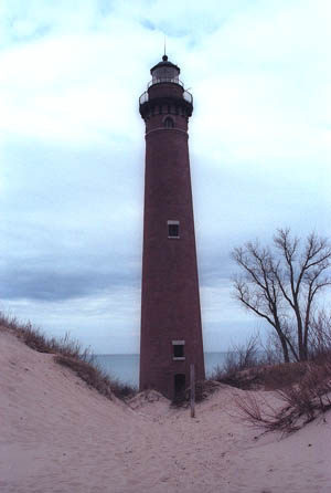
This hike begins with a trek across the dunes and then continues along Lake Michigan to historic Little Sable Point Lighthouse. From there you loop back through the open dunes to the trailhead. The total distance ranges is generally 7 miles but that depends on the exact route you choose through the dunes.
The hike can be done in light walking shoes, even running shoes, since it's easier to dump the sand out of them, but not in bare feet. Don't forget a hat, sunscreen, and a water bottle as trekking through the sand can be hot work in the summer.
| Camping |
| Difficulty - Challenging |
| Difficulty - Moderate |
| Foot Path |
Geo-referenced maps from MichiganTrailMaps.com range from $1.99 to $2.99 each.
Download the Avenza app from the App Store or Google Play


