320

Trails Reviewed

Find Trails & Maps

Search for Trail
Search by Location
Search by

Back to listing

Sleeping Bear Dunes: Sleeping Bear Point Trail


Buy the Geo-referenced map
for use in the Avenza Maps App

Trail Details

County
Leelanau
Regions
Northwest
Latitude
N 44° 54' 33.48"
Longitude
W 086° 02' 20.04"
Distance
2.8 miles
Trail Type
Foot path
Terrain
Sand dunes
Difficulty
Moderate
Nearest City or Town
Glen Arbor
(map loads here)
view map
Avenza Maps
Geo-referenced maps from MichiganTrailMaps.com are available through Avenza Maps and range from $1.99 to $2.99 each.

Download the Avenza app from the App Store or Google Play

App Store Google Play

There are two interesting trails in this incredible corner of Sleeping Bear Dunes National Lakeshore and most visitors head to just one of them - the park's popular Dune Climb and its 4-mile round-trip trek to Lake Michigan. Not nearly as many people make their way to the other trailhead at the end of M-209 located on Sleeping Bear Point itself. Yet step-for-step few trails anywhere in the state are as interesting as Sleeping Bear Point Trail where the open dunes create excellent vantage points and the Manitou Passage provides a good reason to stop and gaze.
Expand All
Photos
Description
There are two interesting trails in this incredible corner of Sleeping Bear Dunes National Lakeshore and most visitors head to just one of them - the park's popular Dune Climb and its 4-mile round-trip trek to Lake Michigan.

Not nearly as many people make their way to the other trailhead at the end of M-209 located on Sleeping Bear Point itself. Yet step-for-step few trails anywhere in the state are as interesting as Sleeping Bear Point Trail where the open dunes create excellent vantage points and the Manitou Passage provides a good reason to stop and gaze.

Don't underestimate this short hike. Walking in sand can be strenuous and in the middle of the summer sunglasses, a wide-brimmed hat, suntan lotion and a quart of water are needed to survive the desert-like heat that radiates off the dunes.

But this trek is not nearly as long or strenuous for young children as the trail from the Dune Climb. And when combined with a visit to the park's Sleeping Bear Point Coast Guard Station Maritime Museum and a dip in the cooling waters of Lake Michigan after the hike, I can't think of a better way for a family to spend an afternoon in the park.
Amenities & Services
Camping
Difficulty - Moderate
Foot Path
Trail Guide

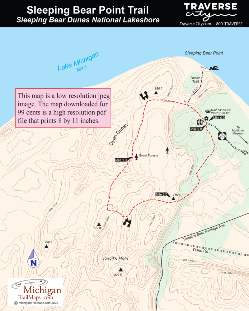
Despite the shifting sand, following the route is easy due to a series of tall, blue-tipped posts. You begin in the woods but quickly are climbing out of the trees near a posted junction. The spur to the right leads a quarter mile through a blowout carved by the wind to a stunning beach along Lake Michigan. The loop heads left.

In a little more than a half mile you top off at the first panorama of the day; there are views in every direction you look. To the west is the Manitou Islands, to the northeast the towering bluffs of Pyramid Point, to the south rolling dunes. At your feet are the many shades of Lake Michigan.

The trail skirts the dune above the point and the panoramic views get even better. Eventually you swing south, descend to a plain of windswept sand and follow blue-tipped poles in crossing it. At the end of the first mile you pass a ghost forest where trees were killed by the migrating dunes and then bleached white by the sun. Another ghost forest is passed and then the trail takes you on a long uphill march, topping off on a series of grass-covered dunes and views of this barren corner of the park. To the south you can peer into Devil\'s Hole, a rugged ravine forested at the bottom by stunted trees.

Almost 2 miles into the loop, the trail begins to loop back and you begin heading in a northerly direction along the crest of another high dune, where the views of Glen Lake are good and any wind off Lake Michigan refreshing. In less than a half mile you drop into the quiet, protected spruce and birch of the forest. There is a sense of relief if you\'re hiking in the middle of the summer as the cooling shade of the trees is a welcome change to the hot sand. At 2.8 miles the trail emerges from the forest at the trailhead and parking area.

Facilities

Sleeping Bear Point Trail has a parking lot with a trailhead information board and vault toilets. Just before reaching the trailhead, you pass the Sleeping Bear Point Maritime Museum. The complex features a lifesaving station museum, historic boathouse, restrooms and drinking water. Even when the museum is not open you can park there and access the beach, a beautiful spot to spend an afternoon watching freighters on the Great Lake.

Hours & Fees

The Sleeping Bear Point Maritime Museum is open daily from mid-May to early September from 11 a.m. to 5 p.m. Through most of September to mid-October the museum is open Saturday and Sunday from noon to 5 p.m. At 3 p.m. daily during the summer an re-enactment of the breeches buoy rescue drill is staged, utilizing Raggedy Ann and Andy as our shipwreck victims. Children love this demonstration.

The trail is open year-round and all visitors are required to have a weekly vehicle entrance permit, an annual park pass or a per-person pass if they arrive on foot, bicycle or motorcycle. Passes can be purchased at the parking booth during the summer or from the Philip Hart Visitor Center in Empire.

Directions

From the headquarters head north on M-22 and then veer off onto M-109. When M-109 turn east towards Glen Arbor, continue on M-209 and follow it to the end. The trailhead parking area is just beyond the park\'s maritime museum.

Information

Call the Philip Hart Visitor Center (231-326-5134) or check the Sleeping Bear Dunes National Lakeshore website (www.nps.gov/slbe).

For travel information contact Traverse City Tourism (800-872-8377; www.traversecity.com).


Geo-referenced maps from MichiganTrailMaps.com range from $1.99 to $2.99 each.

Download the Avenza app from the App Store or Google Play

App Store Google Play

Michigan TrailMaps.com Michigan's Premier Trail Resource Contact

Trail Mix News

by travel and outdoor writer Jim DuFresne!

Sign Up
Enews Signup
Find a Trail

Find Trails & Maps

Search for Trail
Search by Location
Search by