320

Trails Reviewed

Find Trails & Maps

Search for Trail
Search by Location
Search by

Back to listing

Sleeping Bear Dunes: South Manitou Island
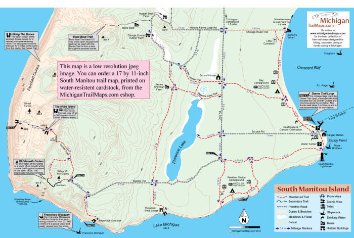
Trail Details

County
Leelanau
Regions
Northwest
Latitude
N 45° 01' 25.68"
Longitude
W 085° 45' 43.20"
Distance
17 miles of trails
Trail Type
Foot path
Terrain
Open dunes, beachs, forests
Difficulty
Moderate to Challenging
Nearest City or Town
Leland
(map loads here)
view map
Click hereto order a detailed map and a guide toSouth Manitou Island.Part of Sleeping Bear Dunes National Lakeshore, South Manitou Island is located 18 miles west of Leland and is the southernmost island of a Lake Michigan archipelago that stretches northeast to the Straits of Mackinac and includes North Manitou Island and Beaver Island.South Manitous most impressive features are the perched dunes along its west side that rise more than 400 feet above Lake Michigan and the lighthouse, boathouses and other historic buildings of a former U.S. Lifesaving Station. Scattered inland are old farmhouses, barns, a schoolhouse and other remains of the islands agricultural past while just offshore ...
Expand All
Photos
Description
Click here to order a detailed map and a guide to South Manitou Island.

Part of Sleeping Bear Dunes National Lakeshore, South Manitou Island is located 18 miles west of Leland and is the southernmost island of a Lake Michigan archipelago that stretches northeast to the Straits of Mackinac and includes North Manitou Island and Beaver Island.

South Manitou’s most impressive features are the perched dunes along its west side that rise more than 400 feet above Lake Michigan and the lighthouse, boathouses and other historic buildings of a former U.S. Lifesaving Station. Scattered inland are old farmhouses, barns, a schoolhouse and other remains of the island's agricultural past while just offshore are several shipwrecks. The 5,260-acres island is also laced with 17 miles of trails and primitive roads that provide day hikers and backpackers access to various historic sites and natural features, including a stand of old growth white cedars, as well as three walk-in campgrounds.

During much of the summer South Manitou is a tropical-like paradise with crescent-shaped beaches, calm, turquoise water and a slow, idyllic pace to it. There is no food service or stores on the island and not transportation other than a motorized tour offered by Manitou Island Transit. Both day and overnight visitors must arrive fully equipped with food, rain gear, sun protection, tents and other camping equipment.

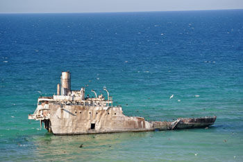
Maintained trails are posted and easy to follow. Secondary trails are not marked but not overly difficult to find. One of South Manitou’s most popular hikes is a 9-mile loop to the perched dunes, including the Valley of the Giants loop and with a return along the shoreline past Francisco Morazan shipwreck.

Shipwrecks
Along with the Francisco Morazan, a freighter that ran aground in 1960, another popular shipwreck is the Three Brothers. Located near the South Manitou Lighthouse, the 162-foot wooden streamer ran aground in 1911 and now lies on the steep slope just 30 yards off Sandy Point. Because her bow is in fairly shallow water, it has since become Michigan’s most popular wreck for snorkelers.

 
Amenities & Services
Camping
Difficulty - Challenging
Difficulty - Moderate
Foot Path
Trail Guide

Click here to order a detailed map and a guide to South Manitou Island.

Facilities

Unlike North Manitou Island, backcountry camping is not allowed on South Manitou. All overnight visitors must stay in one of the island’s three walk-in campgrounds with the closest being Bay Campground, 0.5-mile hike from the ferry wharf. Weather Station overlooking the south shore is 1.3 miles and Popple on the north shore is a one-way trek of 3.7 miles.

Hours & Fees

A vehicle park pass is required to visit South Manitou as well as a backcountry permit for visitors planning to camp there. You can purchase vehicle permits and backcountry permits from a ranger stationed at the Manitou Island Transit office in at Fishtown during the summer.

Directions

Manitou Island Transit (231-256-9061; www.manitoutransit.com) provides ferry service to South Manitou Island from Leland from May to October. From mid-June through Labor Day the boat arrives at South Manitou daily at 11:30 a.m and doesn’t depart the island until 4 p.m., allowing for a 4.5-hour day visit. From June 1 to June 15 there is no service on Tuesday and Thursday, and in May, September. and October service is reduced even further.

Information

The best source of information is Philip Hart Visitor Center (231-326-5134; www.nps.gov/slbe) in Empire. For lodging or travel information contact Traverse City Tourism (800-872-8377; www.traversecity.com).


Geo-referenced maps from MichiganTrailMaps.com range from $1.99 to $2.99 each.

Download the Avenza app from the App Store or Google Play

App Store Google Play

Michigan TrailMaps.com Michigan's Premier Trail Resource Contact

Trail Mix News

by travel and outdoor writer Jim DuFresne!

Sign Up
Enews Signup
Find a Trail

Find Trails & Maps

Search for Trail
Search by Location
Search by