320

Trails Reviewed

Find Trails & Maps

Search for Trail
Search by Location
Search by

Back to listing

Sleeping Bear Dunes: Treat Farm Trail


Buy the Geo-referenced map
for use in the Avenza Maps App

Trail Details

County
Leelanau
Regions
Northwest
Latitude
N 44° 47' 34.08"
Longitude
W 086° 03' 28.80"
Distance
1.1 miles one-way
Trail Type
Foot path
Terrain
Open meadows, hardwoods, perched dunes
Difficulty
Easy
Nearest City or Town
Empire
(map loads here)
view map
Avenza Maps
Geo-referenced maps from MichiganTrailMaps.com are available through Avenza Maps and range from $1.99 to $2.99 each.

Download the Avenza app from the App Store or Google Play

App Store Google Play

Treat Farm Trail is a 1.1-mile walk along an old road to the historic Treat Farmstead and then the edge of Empire Bluff for a panoramic view of Lake Michigan. The adventurous can continue by climbing Old Baldy to a nearly 360-degree vista of the surrounding landscape or carefully thread their way along the perched dunes to the observation deck at the end of the Empire Bluff Trail.
Expand All
Photos
Description
Treat Farm Trail is a 1.1-mile walk along an old road – now gated to prevent motorized traffic – to the historic Treat Farmstead and then the edge of Empire Bluff for a panoramic view of Lake Michigan. The adventurous can continue by climbing Old Baldy to a nearly 360-degree vista of the surrounding landscape or carefully thread their way along the perched dunes to the observation deck at the end of the Empire Bluff Trail.

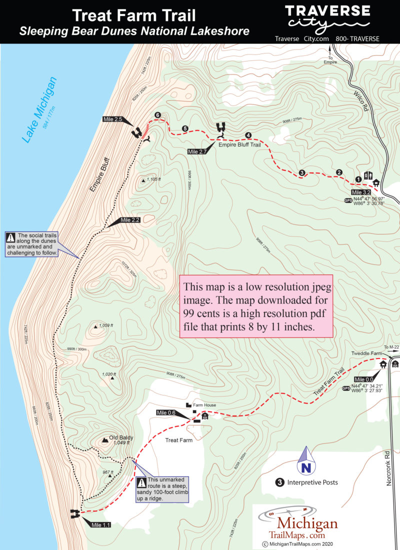
Combining Treat Farm Trail with Empire Bluff Trail would be a semi-loop of 3.2 miles that would leave you 1.2 miles from where you parked your vehicle. That includes 200 yards along M-22, a busy road in the summer.

The Treat Farmhouse was built by the Tweddle family around 1880. In 1895 the Tweddles moved to the picturesque farm at the corner of Norconk Road and in 1912 sold 220 acres to Charles Treat and his wife. The farmhouse, chicken coop, and carpentry workshops were already at the farm when the Treat family moved in.

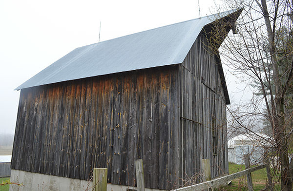
But the farm lacked a barn so Treat purchased one in the Detroit area and had it disassembled, with each piece numbered, and shipped in two railroad cars to Empire. From there it was moved to the current site using a horse-drawn team and Treat, an engineer, laid a foundation and reassembled the barn.

This hike begins across Norconk Road from the historic Tweddle Farm, now used to house National Park Service seasonal employees as well as the park’s Artists-In-Residence program, passes through another farm and rewards you with specular watery views that are the trademark of Sleeping Bear Dunes.
Amenities & Services
Difficulty - Easy
Foot Path
Dog Friendly
Two-Track
Trail Guide

The trail is marked by a vehicle gate at the corner of Norconk Road across from the Tweddle Farm. An old road, now appearing more like a very wide foot trail, heads west into the maple-beech forest that in the spring is carpeted by wildflowers, including trillium, and in the fall painted in autumn shades of red, orange and gold.

At Mile 0.6 you break out of the trees and pass Treat’s barn that was restored by the park in 2004 while off to the right is the farmhouse. Other buildings include sheds, a cistern behind the house and a very unusual concrete dome garage and root cellar.

From the barn, the trail continues southwest to Old Baldy, a 1,049-foot high dune. You reach the base of the dune where a sandy trail ascends its backside. This spur towards the top is a very steep and sandy climb of 100 feet. It’s easier to access the top of old Baldy from its west side. Treat Farm Trail continues to skirt around the dune and at Mile 1.1 reaches a viewing point on a well-shaded bluff overlooking Lake Michigan. A perfect spot for lunch.

From here a social trail heads north along the edge of the bluff, quickly passing others that climb the ridge of Old Baldy to the east. Nothing is marked and the sandy footpaths can change from one year to next. The front of Old Baldy is a mix of open sand and dune grass. Its high point looms almost 500 feet above Lake Michigan. The view from the ridge leading to it is stunning and includes Platte Bay, Platte River Point, the Manitou Islands and a whole lot of water.

To continue to the observation deck you carefully follow social trails along the edge of the perched dune known as Empire Bluff. The trek is roughly 1.5 miles but the exact route changes during periods of high Great Lakes levels which causes the steep dune to sheer off slaps of sand to the beach below. There is a bit of climbing involved with the longest being an ascent of more than 250 feet, reached within a mile. There will also be sections where you find yourself tiptoeing along a narrow edge with the lake 400 feet or more below you.

At roughly Mile 2.5 you arrive at the large viewing deck at the end of the Empire Bluff Trail, a great spot to rest and catch your breath. From here this popular path heads east 0.75 miles to a trailhead off of Wilco Road.

Facilities

There are no facilities at the Treat Farm Trail. The Empire Bluff trailhead features a small picnic area, vault toilet and parking area off Wilco Road.

Hours & Fees

The trail is open year-round and all visitors are required to have a weekly vehicle entrance permit or an annual park pass to Sleeping Bear Dunes National Lakeshore. Passes can be purchased from the Philip Hart Visitor Center in Empire.

Directions

The trailhead is marked by a locked gate on the northwest corner of Norconk Road 2 miles south of the Phillip Hart Visitor Center on M-22 and M-72 in Empire. Parking is on the side of the road.

Information

The Phillip Hart Visitor Center at Sleeping Bear Dunes National Lakeshore is currently closed. For more information stop at the Phillip Hart Visitor Center  on the corner of M-22 and M-72 in Empire or go to park\'s website.


Geo-referenced maps from MichiganTrailMaps.com range from $1.99 to $2.99 each.

Download the Avenza app from the App Store or Google Play

App Store Google Play

Michigan TrailMaps.com Michigan's Premier Trail Resource Contact

Trail Mix News

by travel and outdoor writer Jim DuFresne!

Sign Up
Enews Signup
Find a Trail

Find Trails & Maps

Search for Trail
Search by Location
Search by