320

Trails Reviewed

Find Trails & Maps

Search for Trail
Search by Location
Search by

Back to listing

South Higgins Lake State Park: Marl Lake Trail

Trail Details

County
Roscommon
Regions
Heartland
Latitude
N 44° 25' 24.60"
Longitude
W 084° 40' 29.64"
Distance
2.0 to 5.5 mile loops
Trail Type
Multi-use trail
Terrain
Marl Lake, wetlands
Difficulty
Easy
Nearest City or Town
Roscommon
(map loads here)
view map
Situated on the east side of County Road 100 is an escape from the campers, crowds, and, during the winter, snowmobiles that are the trademark of South Higgins Lake State Park. Marl Lake is the other half of the state park and offers a quiet wooded path that wraps around the shoreline that for much of the year makes for a scenic day hike or an easy mountain bike route.From late December through February the trail system becomes a popular cross-country ski area that is an ideal run for families with young children. Theres an occasional low rise but no hilly portions to fret over. If you need to rent ski equipment, then just to the north onto CO-100 is Cross Country Ski Headquarters(989-82 ...
Expand All
Photos
Description
Situated on the east side of County Road 100 is an escape from the campers, crowds, and, during the winter, snowmobiles that are the trademark of South Higgins Lake State Park. Marl Lake is the other half of the state park and offers a quiet wooded path that wraps around the shoreline that for much of the year makes for a scenic day hike or an easy mountain bike route.

From late December through February the trail system becomes a popular cross-country ski area that is an ideal run for families with young children. There's an occasional low rise but no hilly portions to fret over. If you need to rent ski equipment, then just to the north onto CO-100 is Cross Country Ski Headquarters (989-821-5868).

One of the best times for a hike is autumn as the hardwood trees that are scattered throughout the white and red pine provide brilliant fall colors, and early in the morning you might spot deer anywhere along the route. Keep in mind, however, that the area is open to deer hunting, both archery that begins Oct. 1 and the 16-day firearm season that begins Nov. 15.

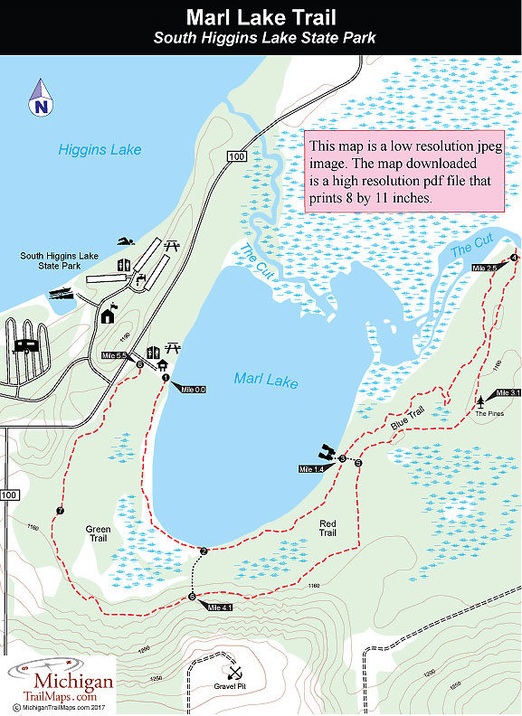
Marl Lake trail is divided into three loops - designated Green, Red and Blue Trails - with the Green being the shortest and a great hike for children even as young as four or five. Only 2 miles long and extremely level, the loop hugs Marl Lake so closely for the first half that there is a water view from every step. The Red Trail is 3.5 miles and reaches a bench on the lakeshore before heading back. The Blue Trail is the entire loop, a 5.5-mile round-trip to the Cut River, passes through small wetland areas that can be muddy in the spring.
Amenities & Services
Camping
Difficulty - Easy
Multi-use Trail
Trail Guide

From the parking area the Green Trail begins at a bridge and from there heads south as a wooded path, hugging the lake for 0.75 mile and providing delightful views of the water through the fringe of pine trees. Right before the first cutoff, you cross two long bridges that provide dry access between the lake to the east and an interesting swamp to the west.

The cutoff is posted with green dots that swing south (right) to reach the return trail; the red and blue dots continue along the lakeshore. The Red Trail stays close to the lake at first then swings away from it slightly. You can still catch slivers of blue between the green pines and the white trunks of the paper birch trees, as well as any wind off the lake.

At Mile 1.4 you reach the second cutoff spur, where a short path leads left down to the shoreline. At the bench here, you can sit and look across the weedy lake to watch others just starting out at the parking area. Marl Lake lies totally in the park allowing its shoreline to be free from cottages and resorts. Its deepest section is only three feet, limiting anglers to canoes or small motorboats. The lake does hold populations of perch, bass, and northern pike and has an unimproved boat launch, but angling activity is light and shore fishing is usually unproductive due to the shallow depth.

At this point, the vast majority of hikers begin their return, which is too bad. The longer Blue Trail takes you past the oldest and most impressive trees of the forest, and it is from this section of the trail that hikers have their best chance of sighting whitetail deer, especially in the early morning or at dusk. Even if you don't see the animals themselves, their tracks often cover the path.

The Blue Trail immediately moves out of view of the water into a mixed forest of pine, maple, oak, and beech. It can get wet and muddy in places, but manageable for anybody wearing hiking boots, even a low-cut pair. The blue diamonds embedded in the trees are mostly six to seven feet off the ground. In the winter, skiers might have trouble following the route after a fresh snowfall, but hikers encounter few problems.

At Mile 2.5 you arrive at a spot where the trail merges into an old two-track road and begins its return journey. But to the north (left) is a short trail that leads down to the Cut, the channel that flows between Higgins Lake and Houghton Lake, passing through the north end of Marl Lake along the way. The waterway is a popular canoe route, and you might hear or see a few rental canoes banging their way down the channel.

The return trip on the loop follows an old vehicle track and is considerably wider, and drier, than the first half. It winds through mostly hardwoods, but at Mile 3.1 reaches a stand of pine with one particularly impressive white pine towering right above you. In another 0.3 mile, you come to the junction with the second cutover spur. The main trail continues southwest along the old two-track road and in Mile 4.1, you arrive at the first cutover spur.

The remaining of the return loop swings near a gravel pit, winds through some clearings, and ends up paralleling County Road 100, where on a summer weekend the traffic roars by. The alternative is to follow the first crossover spur and re-hike the most scenic stretch of the trail. For most hikers, that's no choice at all.
Facilities

South Higgins Lake features the second largest campground in a state park. The facility has 400 modern sites and one Mini-cabin situated close together in an area well shaded by hardwoods. There are no sites on the lake, but all are only a short walk from the lakeshore. Despite its size, the campground fills up daily from the Fourth of July holiday to early August and on weekends after that to the Labor Day holiday.

The park’s day-use area is on Higgins Lake and consists primarily of a grassy bank with many picnic tables only an arm's length away from the water. There is little in the way of a sandy beach, but the designated swimming area has a sandy and shallow bottom ideal for young children. There are two picnic shelter, store-bathhouse and parking for almost 500 vehicles, although the lot fills up most weekends in July and additional visitors are forced to leave their cars outside the park and walk in.

A boat rental concession rents out canoes, rowboats, small motorboats, sailboats and even pontoons and is open daily from Memorial Day to Labor Day.

Hours & Fees

South Higgins Lake State Park is open year round and a vehicle permit or annual state park pass is required to enter either the day-use area or Marl Lake Trail.

Directions

From I-75, exit at Roscommon (exit 239). Head south, away from the town, and immediately turn west (right) onto County Road 103, where there is a state park sign. Follow County Road 103 for 3 miles, then turn south (left) onto County Road 100 for 3 more miles. The Marl Lake parking lot is located right before the main entrance to the state park on the east (left) side of County Road 100.

Information

The park headquarters (989-821-6374) is on the west side of County Road 100 in the day-use area. For a campsite or mini-cabin reservation contact Michigan State Park Central Reservations (800-447-2757; www.midnrreservations.com)


Geo-referenced maps from MichiganTrailMaps.com range from $1.99 to $2.99 each.

Download the Avenza app from the App Store or Google Play

App Store Google Play

Michigan TrailMaps.com Michigan's Premier Trail Resource Contact

Trail Mix News

by travel and outdoor writer Jim DuFresne!

Sign Up
Enews Signup
Find a Trail

Find Trails & Maps

Search for Trail
Search by Location
Search by