320

Trails Reviewed

Find Trails & Maps

Search for Trail
Search by Location
Search by

Back to listing

U of M Biological Station: Gorge Trails

Trail Details

County
Emmet
Regions
Northwest
Latitude
N 45° 33' 18.00"
Longitude
W 084° 41' 15.36"
Distance
1.9 miles
Trail Type
Foot path, cross-country ski trail
Terrain
Gorge, Carp Creek
Difficulty
Easy
Nearest City or Town
Pellston
(map loads here)
view map
The 10,000-acre University of Michigan Biological Station is spread between Douglas and Burt Lake with most of it open to the public. Spread across the Station is a trail system with the most interesting paths being the Gorge Trails that skirt and dip into a ravine more than a 100 feet deep in places.
Expand All
Photos
Description
During peak fall colors, the Gorge Trails at the University of Michigan Biological Station on the edge of Emmet County make for a beautiful hike. Wait until there are no leaves on the trees and this unusual trail gets even better.

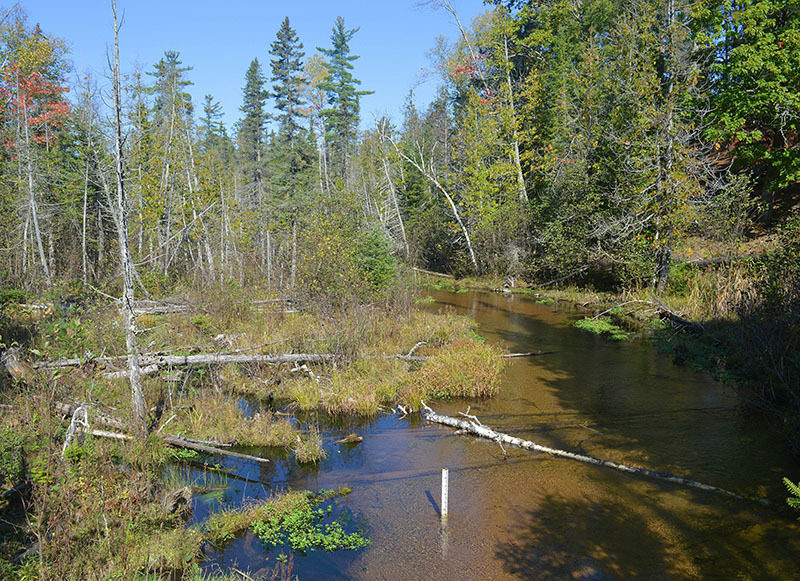
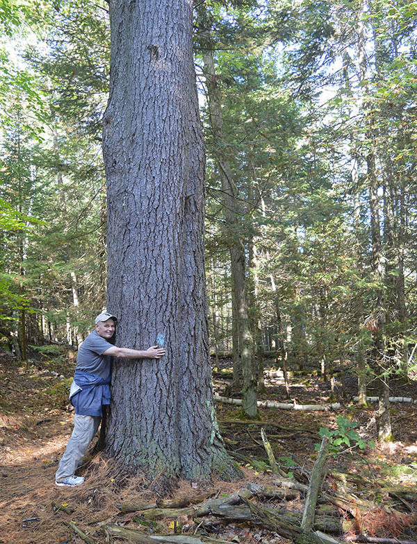
Founded in 1909 on land acquired from lumber barons after the area had been logged, the 10,000-acre Biological Station is spread between Douglas and Burt Lake with shoreline on both. The trees have since grown back and the station now features a rich diversity of natural habitats: extensive forests of pine and northern hardwoods, conifer swamps, meadows, all types of wetlands, rivers and streams.

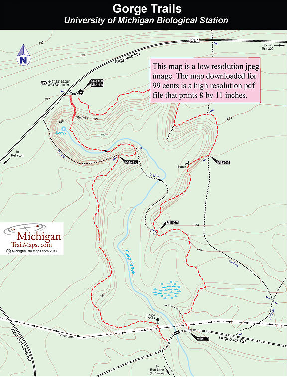
Much of the station is open to the public and spread across it is a trail system that is a favorite among locals as a Nordic destination in the winter. But the most interesting paths here are the Gorge Trails that skirt and dip into a ravine more than a 100 feet deep. The less leaves on the trees the better as you are able to stand on the edge of this cleft and peer at Carp Creek at the bottom or the walls on the other side that enclose this narrow gorge.

The gorge is an example of an erosional process call sapping, the result of Douglas Lake being 118 feet higher than Burt Lake. Water drains from Douglas Lake by seeping underground for a half mile and then reappearing as springs in head of the gorge. The springs are the headwaters of Carp Creek that flows almost 2 miles south before emptying into Burt Lake. Give this small stream credit; in 8,000 years it’s manage to carve an impressive ravine here.

Since 2005 locals and U of M students and staff has improved, marked and expanded the trail system around Carp Creek Gorge. In particular, a huge stairway at the head of the gorge was rebuilt allowing quick access to the springs at the bottom.

This 1.9-mile loop follows the edge of the ravine for the best views and then descends into it before using the stairway for an easier climb back to the trailhead parking area. To extend hike, you can add the point-to-point segment that heads south from Hogsback Road through Reese’s Swamp to Burt Lake, turning this into a 3.64-mile outing.
Amenities & Services
Difficulty - Easy
Foot Path
Trail Guide

At the back of the parking area a trail heads into the woods and quickly comes to the edge of the gorge. Peer down and sharp eyes might spot the gurgling Carp Creek. The first junction is not posted; an unofficial trail reached in a 0.3 mile that descends sharply into the ravine. The rest are well marked with the next junction being a path that heads north for Riggsville Road. Stay right to continue skirting the gorge and at Mile 0.5 you'll arrive at a third junction. The left-hand fork is a trail that wanders away from the ravine for Hogsback Road.

The right hand-fork stays on the edge and quickly reaches a bench with a good view into the gorge. There is a bit of climbing in next quarter mile but you remain on top, reaching the fourth junction at Mile 0.7. Here a trail descends and crosses Carp Creek at the bottom. Head left to stay to stay on top and at Mile 1 will reach a short stairway descending to Hogsback Road.

Follow the dirt road west to quickly cross a vehicle bridge over Carp Creek, your first close-up view of this beautiful, cold-water stream. On the other side is a water gauge station where you can help researchers by recording the height of the stream as indicated by a ruler in the middle of it. Just beyond the station a posted trail heads north from Hogsback Road.

You quickly pass under a power line, return to the woods on the other side and then pass some large pines. One white pine in particular looks like it belongs in Hartwick Pines State Park. Within a quarter mile you’re back on the edge of the gorge, enjoying some of the finest views of the day.  The only junction on the west side of the gorge is at Mile 1.6. You’re 0.3 mile from the trailhead and can reach it with either fork. To the left you remain on top of the ravine and then follow Riggsville Road the final 100 yards to the parking lot.

The right-hand fork is much more interesting. The trail descends to bottom of Carp Creek Gorge, passes a junction with the trail that descends into the ravine from the east side and uses a foot bridge to cross the stream. On the other side you skirt the main channel of Carp Creek but pass several small feeder tributaries until reaching the main spring, bubbling out of the hillside at the head of the gorge. At this point the trail makes a sharp swing to the northeast and quickly reaches the stairway that leads to the trailhead at the top of the gorge.

Facilities

Other than parking there are no other facilities or drinking water at the trailhead for Gorge Trails.

Hours & Fees

The trails are open year-round. There are no entry or vehicle fees to park at the trailhead.

Directions

From US-31 in Pelliston, turn east onto County Road C-64 which in town is Mill Street, then becomes Robinson Road and finally Riggsville Road. Within 5 miles the trailhead parking area will appear among the trees on the south side of Riggsville Road. From I-75, depart at exit 322 and head 3.6 miles west on Riggsville Road to the unmarked trailhead.

Information

For more information, contact the University of Michigan Biological Station in Pelliston at (231) 539-8408. For travel information contact the Petoskey Area Visitors Bureau at 800-845-2828.


Geo-referenced maps from MichiganTrailMaps.com range from $1.99 to $2.99 each.

Download the Avenza app from the App Store or Google Play

App Store Google Play

Michigan TrailMaps.com Michigan's Premier Trail Resource Contact

Trail Mix News

by travel and outdoor writer Jim DuFresne!

Sign Up
Enews Signup
Find a Trail

Find Trails & Maps

Search for Trail
Search by Location
Search by