320

Trails Reviewed

Find Trails & Maps

Search for Trail
Search by Location
Search by

Back to listing

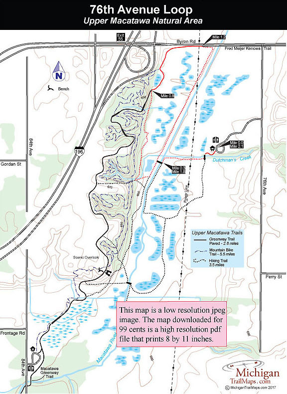
Upper Macatawa Natural Area: 76th Avenue Loop

Trail Details

County
Ottawa
Regions
Lake Michigan
Latitude
N 42° 49' 36.12"
Longitude
W 085° 58' 36.12"
Distance
1.75-mile loop
Trail Type
Mowed lanes, foot paths
Terrain
Macatawa River, wetlands
Difficulty
Easy
Nearest City or Town
Zeeland
(map loads here)
view map
A loop departing from the 76th Avenue trailhead heads to the north end of Upper Macatawa Natural Area, along the way sidling the Macatawa River. You pass beneath a power line four times along this 1.75-mile hike and the scenery is not nearly as interesting as the84th Avenue Loop. But the terrain is level and the walking easy.
Expand All
Photos
Description
A loop departing from the 76th Avenue trailhead heads to the north end of Upper Macatawa Natural Area, along the way sidling the Macatawa River. You pass beneath a power line four times along this 1.75-mile hike and the scenery is not nearly as interesting as the 84th Avenue Loop. But the terrain is level and the walking easy.
Amenities & Services
Difficulty - Easy
Dog Friendly
Foot Path
Trail Guide

From the parking area a paved trail leads south 100 yards to a bridge across Dutchman’s Creek and post No. 5 on the other side. Head west (right) and a mowed lane will skirt the small stream and pass underneath the power lines.

At Mile 0.3 you use a bridge to cross Macatawa River to post No. 3 and then head north (right) to follow the river for the next half mile and walk beneath the power lines a second time. Most of the year the Upper Macatawa River is more a drainage ditch than a river. Just before Mile 1 the trail reaches post No. 4 near Byron Road and then swings west along a stretch where it is easy to lose the trail.

Eventually you reach the base of the ridge that encloses the Upper Macatawa floodplain and head south to return to post No. 3, reached at Mile 1.5. Re-cross Macatawa River to return to the 74th Avenue trailhead or continue south to add the 84th Avenue Loop and turn this hike into a 4.3-mile outing.

Facilities

The trailhead parking areas are off 84th and 76th Avenues and feature parking, vault toilets and information kiosks.

Hours & Fees

The Upper Macatawa Natural Area is open 7 a.m. to 10 p.m. from April through October 31 and 7 a.m. to 8 p.m. the rest of the year. There are no vehicle or entry fees.

Directions

The Upper Macatawa Natural Area is located in Zeeland Township. To reach the 84th Avenue trailhead depart I-196 at exit 52 and head east on Adams Street and then north on 84th Avenue. The 76th Avenue trailhead is reached by departing I-196 at exit 55and heading east on Byron Road on 76th Avenue.

Information

Contact Ottawa County Parks and Recreation Commission at (616) 738-4810 or www.miottawa.org/parks.


Geo-referenced maps from MichiganTrailMaps.com range from $1.99 to $2.99 each.

Download the Avenza app from the App Store or Google Play

App Store Google Play

Michigan TrailMaps.com Michigan's Premier Trail Resource Contact

Trail Mix News

by travel and outdoor writer Jim DuFresne!

Sign Up
Enews Signup
Find a Trail

Find Trails & Maps

Search for Trail
Search by Location
Search by