Warren Dunes State Park: Mt. Randal Loop
Buy the $.99 downloadable map!
(This map is not geo-referenced)Trail Details

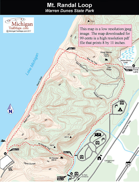
For visitors not familiar with Michigan’s dune country, the geology of this area can be intriguing. Along the hike you’ll be able to spot the different types of dunes from in this park: parallel dunes, blowouts, and parabolic dunes or parallel dunes that have been carved by a series of wind-blown indentations. To help understand the unique natural aspects of the area, a handful of interpretive displays have been erected within the park.
It’s important for hikers to understand that Warren Dunes’ close proximity to several major urban areas, including Chicago, results in the park having the second highest number of visitors of any state park. The vast majority are out-of-staters arriving from June to September. If you hike to sneak away from crowds and other signs of humanity, Warren Dunes is not the place to go on the Fourth of July.
The best time to venture into the park is when the wildflowers bloom in April, or in mid- to late October when the leaves of the hardwood forests are touched with brilliant hues of oranges and reds. Arrive in mid-week during these off-season months and the crowds will be gone, the campground practically empty, and often you'll be the only one on a stretch of beach.
If you are planning to arrive during the summer, the best days are Mondays and Tuesdays, the lull between the weekend crowds. By Wednesday the campground is filling up again, and Saturday there often are so many people at Warren Dunes that parking is almost impossible. If this is the case, avoid the main entrance and begin the loop off Floral Lane. Better yet, head north and explore Grand Mere State Park, saving this hike for another day.
Also keep in mind that there are quite a few dunes to climb during the outing. Children under the age of six and others with weak knees might require more time than the normal two to three hours most people need for this hike.
| Camping |
| Difficulty - Moderate |
| Dog Friendly |
| Foot Path |
Geo-referenced maps from MichiganTrailMaps.com range from $1.99 to $2.99 each.
Download the Avenza app from the App Store or Google Play


