
Whaleback Natural Area
Buy the $.99 downloadable map!
(This map is not geo-referenced)Buy the Geo-referenced map
for use in the Avenza Maps App
Trail Details
Geo-referenced maps from MichiganTrailMaps.com are available through Avenza Maps and range from $1.99 to $2.99 each.
Download the Avenza app from the App Store or Google Play


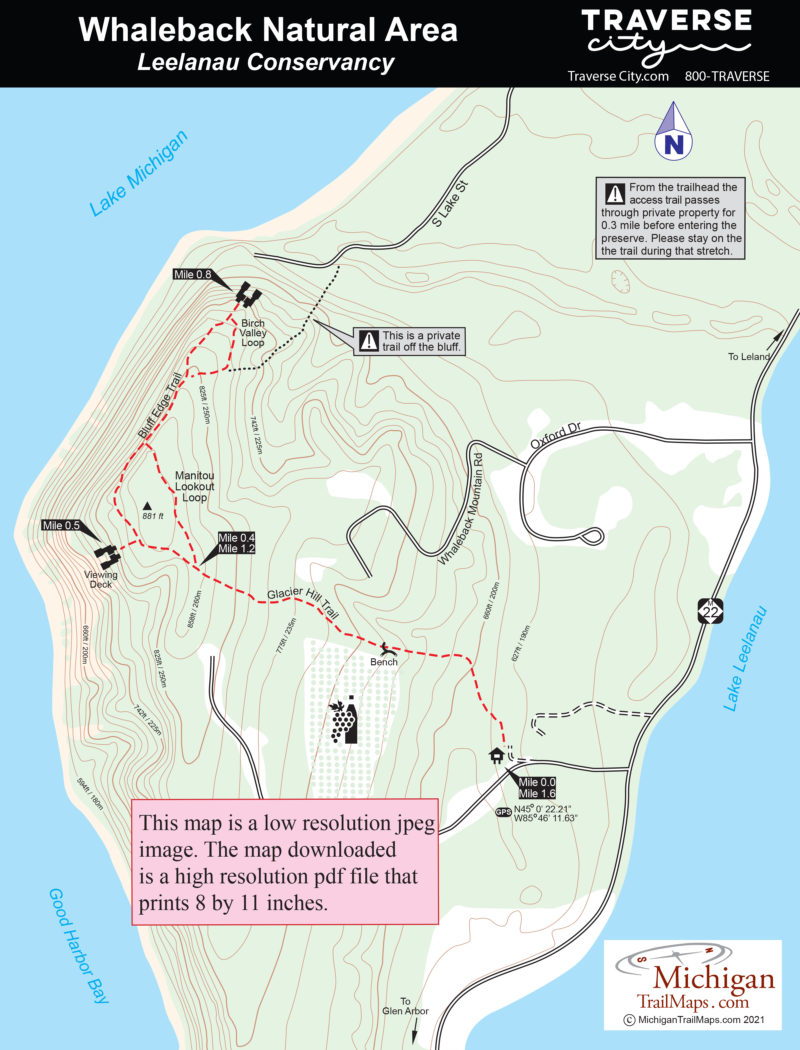
Whaleback catches the attention of anyone scanning Lake Michigan from afar. To many the distinctive ridge looks like a beached whale, one they can spot standing in Leland’s Fishtown, on a high point in northern Leelanau County or from several beaches in the area, particularly Good Harbor Bay which the point encloses to the north. Encompassing 117 acres and 3700 feet of lakeshore, Whaleback's bluffs tower 300 feet above Lake Michigan and has long been used by sailors as a point of reference.
This whale is actually a moraine. Formed by a glacier 11,000 years ago, Whaleback is, in geologist terms, a “drumlin,” a long, oval mound of glacial drift that was molded in the same direction as the original flow of ice. What was left behind was a geologic wonder with spectacular views from the edge of its steep-sided ridge and a terrain supporting a variety of plants and wildlife, all within easy walking distance from one of Northern Michigan’s most popular tourist towns.
Whaleback had to be preserved. In 1996, the Leelanau Conservancy completed the task when it raised $850,000 to acquire 40 acres of the coastal bluff and the rocky beach at the base of it. Whaleback Natural Area was open to the public after the conservancy worked with surrounding landowners to develop a trail across private property to its newest preserve. The natural area is small and the trail system limited, not much more than a mile of paths.
The views are what attract most hikers to Whaleback but the flora can be fascinating. In the spring, the forest is covered by vast swaths of wildflowers such as trillium and columbine. In the fall hardwoods create a colorful canopy above the trail. Whaleback’s most unusual resident is the thimbleberry, a large raspberry-like fruit that is common along Lake Superior in the western Upper Peninsula but rarely seen in the Lower Peninsula.
The trails at Whaleback can be combined for a 1.6-mile hike from the trailhead just off M-22. The distances are short but the climb up to the top of the bluff is steady, making the natural area a moderately challenging outing.
| Difficulty - Easy |
| Foot Path |
Geo-referenced maps from MichiganTrailMaps.com range from $1.99 to $2.99 each.
Download the Avenza app from the App Store or Google Play
