320

Trails Reviewed

Find Trails & Maps

Search for Trail
Search by Location
Search by

Back to listing

Young State Park: White Birch Nature Trail

Trail Details

County
Charlevoix
Regions
Northwest
Latitude
N 45° 14' 8.52"
Longitude
W 085° 02' 37.32"
Distance
1.5-mile loop
Trail Type
Foot path
Terrain
Lake Charlevoix
Difficulty
Easy
Nearest City or Town
Boyne City
(map loads here)
view map
Young State Parks shortest trail, the White Birch Nature Trail, is its most popular during the summer and for good reason. The first half of the 1.5-mile loop skirts Lake Charlevoix, providing easy access to the water and good views of Boyne City and Avalanche Peak towering above the west shore.White Birch is popular among campers and families who want to explore the park beyond the beach and day-use area. The trail is closed to mountain bikes and the walk is short, level and usually dry even in the spring. Despite its name there is no brochure or interpretive signage along the path.The trailhead for White Birch is located adjacent to the boat launch in Terrace Campground and from the lo ...
Expand All
Photos
Description

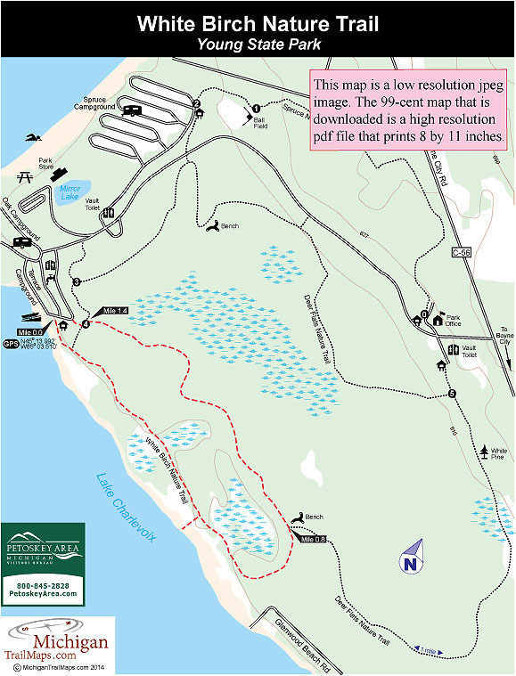
Young State Park’s shortest trail, the White Birch Nature Trail, is it’s most popular during the summer and for good reason. The first half of the 1.5-mile loop skirts Lake Charlevoix, providing easy access to the water and good views of Boyne City and Avalanche Peak towering above the west shore.

White Birch is popular among campers and families who want to explore the park beyond the beach and day-use area. The trail is closed to mountain bikes and the walk is short, level and usually dry even in the spring. Despite its name there is no brochure or interpretive signage along the path.

The trailhead for White Birch is located adjacent to the boat launch in Terrace Campground and from the loop begins with the portion along Lake Charlevoix.

Amenities & Services
Camping
Difficulty - Easy
Dog Friendly
Foot Path
Trail Guide

White Birch departs the boat launch area and immediately begins skirting Lake Charlevoix. This is scenic hiking and at Mile 0.5 you have the opportunity to follow a very short spur down to the water.

Along the shoreline here are upside forests; stands of cedar trees that have been stuck upside down in the lake with their short, twisted roots reaching for the sky. No doubt an inspired artist created these natural sculptures.

The trail begins to swing away from the lake at Mile 0.7 into a forest of cedar and white birch and quickly reaches a junction with a display map and bench. Head west (left) to follow the second half of the loop that remains totally in the woods and at one point uses a series of logs to keep you out of the mud. The trail arrives at post No. 4 at Mile 1.4 where you head left to quickly return at the boat launch.

Facilities

Young State Park has 240 modern sites spread out in three campgrounds. Oak Campground has 41 sites, including a row of them right on the shoreline of Lake Charlevoix, while next to it is Terrace Campground with an additional 41 sites. Both are wooded areas with well-shaded sites to make camp. Spruce Campground, north of the day-use facility, is the largest with 158 sites situated in an open, grassy area. The three campgrounds are often filled from the Fourth of July weekend to mid-August.

There are 1.5-miles of lakeshore within the park including a wide, sandy beach in its day-use area. Overlooking the beach and a grassy picnic area is a concession store while in Terrace Campground is a boat ramp. Other facilities at Young State Park include a softball field and outdoor basketball court.

Hours & Fees

The park is open year round, offering Nordic skiing and snowshoeing in the winter. A vehicle permit or annual state park pass is required to enter.

Directions

From Boyne City head northwest on Boyne City Road (County Road 56) 1.5 miles to the park entrance.

Information

For more information on the park contact Young State Park (231-582-7523) while campsites can be reserved online (www.midnrreservations.com) or by phone (800-447-2757). For lodging or other travel information contact the Petoskey Area Visitors Bureau (231-348-2755, 800-845-2828; www.petoskeyarea.com).


Geo-referenced maps from MichiganTrailMaps.com range from $1.99 to $2.99 each.

Download the Avenza app from the App Store or Google Play

App Store Google Play

Michigan TrailMaps.com Michigan's Premier Trail Resource Contact

Trail Mix News

by travel and outdoor writer Jim DuFresne!

Sign Up
Enews Signup
Find a Trail

Find Trails & Maps

Search for Trail
Search by Location
Search by