A Holiday Sale And A Journey To Death Valley
Editor’s Note: Tis the season … to scramble around for last minute stocking stuffers. We’re here to help. MichiganTrailMaps.com is having its first holiday sale. Order a book and we’ll throw in one of our new trail maps, a $4.95 value!
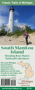
Order any book from our e-shop and fill in the “Name of Free Trail Map” box to let us know which map to send you. It could be Jordan River Pathway, Manistee River Trail or our newest that just arrived from the printer, South Manitou Island. Also don’t forget to fill in the “Autograph Book For” box so author Jim DuFresne can dedicate it to whoever you want. You’ll receive a personalized Christmas gift for somebody and a detailed map for next summer’s adventure.
Journey To A Deadly Valley
By Jim DuFresne
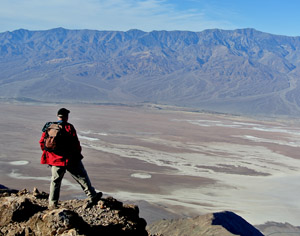
I’m hiking along an open ridge at 5,475 feet with 360-degree views all around me; peaks and entire mountain ranges, valleys and a road that looks like a ribbon. I stop at an outcropping to briefly get out of the wind and, as amazing as the scenery has been so far, I’m stunned at what I see now.
Straight below me is a whitish plain, Badwater Basin, the lowest point in the Western Hemisphere at 282 feet below sea level. On the horizon to the west, poking its icy crown above a mountain range, is Mt. Whitney, at 14,505 feet the highest point in the contiguous United States. I’m looking at the floor and the ceiling of our country from one of the most amazing parks within it.
Death Valley National Park, a land of great extremes.
When my brother had an extra week off he called the one person he knew is always up for a hiking adventure. He baited me into flying out to California by saying we could spend a few days at this 3.4-million acre park that is only two hours from Las Vegas.
“It’s always been on my bucket list,” he said. It should be on everybody’s bucket list.
Death Valley is a blend of craggy mountain peaks, sand dunes, low valleys and rocky gullies that has been sculptured into every possible shape and color, a surreal landscape that is jagged, rugged, severe, beautiful and sublime all at once. Much of the area is barren – the reason you have places named Devil’s Golf Course, Dante’s View, Deadman Pass and Coffin Peak. But it also supports nearly 1,000 native plant species and harbors fish, snails and other aquatic animals found nowhere else.
The land of great extremes.

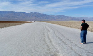
Hiking across salt in Badwater Basin In Death Valley National Park, the lowest point in the country.
For most people Death Valley is synonymous with the Borax 20-mule teams from the 1960s TV show, Death Valley Days, and scorching temperatures. Three moisture-trapping ranges to the west cast Death Valley in a deep rain shadow, making it a very dry and hot place. The average high in July is 118 degrees, the lows at night only 88 degrees.
Last July the temperature rose to 128 degrees at one point and on July 10, 1913 it hit 134 degrees, the highest temperature ever recorded in the world. “It was so hot that swallows in full flight fell to the earth dead,” said a Death Valley ranch hand at the time.
But when we arrived in mid-November the daytime temperature, even on the valley floor, was a comfortable mid-70s and it was sunny every day, great weather for hiking. At night it would drop to the upper 40s, chilly enough to justify fleece, and in the winter the mountains that enclose Badwater Basin, the heart of Death Valley, are covered with snow.
The main centers of activity in Death Valley are Furnace Creek and Stovepipe Wells which include park resorts, limited supplies, campgrounds and visitor centers. Both are located on paved State Highway 190.
There are four other major paved roads in this massive park and then it’s dirt roads and two-tracks, most recommended only for high clearance vehicles or four-wheel-drive jeeps and SUVs. Even then you must be careful when you leave the pavement for the backcountry. This is how the National Park Service makes that point in its official visitors guide:
You’ve got two flat tires. Your cell phone doesn’t work. Nobody knows where you are. You’re not sure where you are. You haven’t seen another car since you turned off the highway 12 hours ago. The only thing you can hear is the ringing in your ears. Is this how you thought it would end?
Wow, and we were driving a plug-in Prius.
We stuck to the pavement or close to it but had no problem filling three days with things to see. We checked out the Harmony Borax Works mining ruins, followed Artist’s Drive through multi-hued volcanic hills with a late afternoon sun setting behind us, rose early the next morning and watched it rise over the perfectly smooth curvatures of the Mesquite Flats Sand Dunes.
The highlight of the trip, however, was the hiking.
We drove up to Dante’s View, a 5000-foot overlook, and from there ridge walked for miles. We snaked our way through Golden Canyon to a high pinkish bluff known as Red Cathedral. We explored the narrow passages, old borax mines, dry waterfalls and colorful Badland-like setting in Gower Gulch.
In the end the most amazing hike was the shortest. From the road, it’s less than a mile before you’re standing in Badwater Basin, a salt flat that is almost pure white. Here in the lowest place in the country you’re surrounded by mountains and on one ridge a sign has been placed so high above the valley floor you have to squint to read it: Sea Level.
Indeed, a strange land of great extremes.
For more on Death Valley National Park go to www.nps.gov/deva or call the Furnace Creek Visitor Center at 760-786-3200.


