Lending A Hand For A New Trail
There are new backpacking trails on the horizon for Michigan but they could use a helping hand in the planning and development of them. Read about them in the latest Trail Talk or check out other recent blogs at our newly re-launch MichiganTrailMaps.com website (www.michigantrailmaps.com).
By Jim DuFresne
Last week they had another ribbon cutting ceremony for a new trail in Michigan. At a former railroad trestle, the latest segment of the Fred Meijer Grand River Valley Rail Trail (www.rivervalleyrailtrails.org) was dedicated and is now open. Spanning from Ionia to Saranac, through the heart of the Ionia State Recreation Area, the 8 miles of asphalt and crushed-limestone path is another step towards a 125-mile trail system of four rail-trail corridors that when finally linked together will be the fifth longest rail-trail in the USA.

Jim DuFresne
We love trails in Michigan and new trails being announced or unveiled is becoming a common occurrence here:
—Dedicated in August was a new 12-mile section of the Iron Ore Heritage Trail (ironoreheritage.com), connecting Marquette and Negaunee and completing a 29-mile route from Chocolay Township, east of Marquette, all the way to Ishpeming.
—This fall the Macatawa Greenway Trail (www.miottawa.org/Parks/greenway.htm) in Ottawa County was constructed. The a 2.5-mile paved path runs through the scenic Upper Macatawa Natural Area and links the Fred Meijer Kenowa Trail with an existing Holland Township path that heads west into Holland, thanks to a newly completed pedestrian bridge over I-196.
— Next July an additional 5.5 miles of the Sleeping Bear Heritage Trail (sleepingbeartrail.org) will open. The paved path will then extend from Glen Arbor to Empire, with much of it through Sleeping Bear Dunes National Lakeshore. When complete, the trail will stretch 27 miles—from Good Harbor Beach at County Road 651 to Manning Road, just south of Empire.
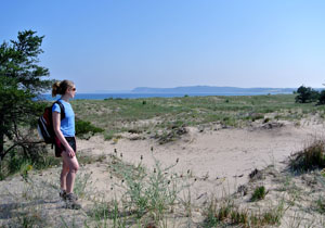
A hiker on the Platte Plains Trail that would be part of the proposed Bay-To-Bay Trail across Sleeping Bear Dunes National Lakeshore.
What the above trails have in common is they’re geared for dayuse, whether you are a mountain biker, hiker or trail runner. Many are paved, pass through communities or are the result of rail-trail acquisitions.
The most difficult trails to create are backpacking routes, paths that lead you away from urbanization – not to mention traffic jams, weekend crowds and shopping malls – and into the woods. For a few days or just overnight you can be in the wild, soaking up nature, listening to the surf on an isolated stretch of beach as oppose to your neighbor on his riding lawn mower.
That’s what makes two new trail projects so unusual. The primary purpose of them is to escape, for days at a time if you want, because for the most part, they are long foot paths into rugged and scenic areas of the Lower Peninsula that are still semi-isolated.
The proposed Bay-To-Bay Trail will traverse the length of Sleeping Bear Dunes National Lakeshore. It will wind 35 miles deep into the park’s backcountry from Old Indian Trail north of Frankfort to Good Harbor Bay, northeast of Glen Arbor. It will be a combination of existing trails, old two-tracks and newly constructed trail segments that will include such renowned natural features as Platte Bay, the Dune Climb, North Bar Lake and Pyramid Point.
It will pass through the towns of Empire and Glen Arbor but is being designed as a backcountry recreational experience for backpackers and paddlers. Along with a foot path, Bay-To-Bay will also feature a water trail for multi-day kayaking along the Lake Michigan shoreline. At night both groups will share the same series of backcountry campgrounds located in remote areas of the park that are now hard to access.
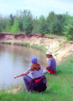
Members of Grand Traverse Hiking Club take a break at the Manistee River while following the North Country Trail.
You can help greatly with the design of this trail by taking the surveys that were created to gather information on what potential users want in such a trail. One for is paddlers, the other for backpackers, and each contains approximately 20 questions that require 15 minutes or less to complete.
If you are a backpacker the survey can be found at: https://www.surveymonkey.com/s/SLBEB2B_bckpckr. If you are a paddler then head online to: https://www.surveymonkey.com/s/SLBEB2B_pddlr
The Fife Lake Loop Trail is ambitious project by the Grand Traverse Hiking Club, a chapter of the North Country Trail Association. It includes re-routing a portion of the North Country Trail to bypass Fife Lake and building a second trail to create a 20 to 25-mile loop with the NCT through Wexford and Grand Traverse Counties.
The new trail would depart the NCT near Old US-131 State Forest Campground, head east and follow the banks of the Manistee River for 2 miles to the mouth of Fife Lake Creek. Here you would head north and follow the fast-moving creek through delightful stands of towering pines and cedars and pass a series of small, undeveloped lakes. Eventually you reach Spring Lake State Forest Campground, a rustic facility of 32 sites overlooking its namesake lake that would make an ideal place to overnight. The next day you would pick up the NCT to head south to reach your starting point.
Work on the new trail began this summer and club officials anticipate the project requiring two years to finish. You can help by joining the club or volunteering for work parties by contacting the Grand Traverse Hiking Club (www.northcountrytrail.org/gtr/).


I was looking evyrrwheee and this popped up like nothing!