County Road 371: One Short & Adventurous Drive
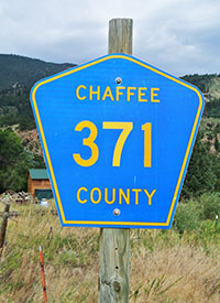 In the latest Trail Talk blog from MichiganTrailMaps.com, Jim DuFresne writes about the most amazing road he has ever followed in Colorado. Country Road 371 offers spectacular scenery, lots of outdoor adventure and places to camp. Even more amazing, CR 371 is only 10 miles long.
Jim no more flew back to Detroit then he immediately drove north to begin working on our expanded coverage of the Porcupine Mountains Wilderness State Park. An updated version of his longtime guidebook is slate
d to be out next spring. But before then we’ll be uploading maps, trail coverage and blogs to our web site. Our next Trail Mix newsletter will be devoted to the beloved Porkies. Sign up now at michigantrailmaps.com/newsletter to make sure you get the free newsletter that comes with our newest downloadable maps.
By Jim DuFresne
The Arkansas Headwaters Recreation Area is a vast stretch of Colorado that covers 109,107 acres from the historic town of Leadville south to Pueblo on the edge of Great Plains, protecting 152 miles of the Arkansas River, the state’s longest. The area is so vast it’s managed by three agencies; Bureau of Land Management, Colorado Parks and Wildlife and the U.S. Forest Service.

Jim DuFresne
North of Buena Vista the upper valley of the recreation area is stunningly scenic, a valley of towering peaks and steep canyons that slices through the Sawatch Mountains, Colorado’s highest range, and is accessed primarily by US-24. But departing the highway are two-tracks, forest roads and easily overlooked dirt roads. Like County Road 371, perhaps the most intriguing one of them all.
And it’s only 10 miles long.
But it’s hard to imagine many roads in Colorado, and there are none in Michigan, that offer so much outdoor adventure, places to camp and panoramic views – along with the pull-offs to gaze at them – in such a short distance as this Chaffee County Road.
CR 371 begins as Colorado Street in the historic downtown area of Buena Vista, the result of a gold rush in the 1860s and a popular stagecoach stop until three railroad lines arrived in the mid 1880s. From there the county road heads north as a paved avenue but by Mile 2 it’s a graded dirt road, winding past rocky bluffs with Buena Vista nowhere to be seen.

Rafters on the Arkansas River along County Road 371.
Above you can watch rock climbers carefully making their way up sheer stone faces. Below CR 371 is a thunderous display of whitewater, curls and drops that is the Arkansas River. If it’s July or August you’ll also see rafters bobbing their way downriver. A lot of them.
The Arkansas Headwaters Recreation Area is generally regarded as one of the country’s most popular locations for whitewater rafting and kayaking and the Upper Arkansas River is the most commercially rafted river in the United States. Period. That’s why there are half dozen commercial raft companies in and around Buena Vista – Wilderness Aware Rafting, KODI Rafting and Browns Canyon Rafting to name but a few – and even more lining the river all the way downstream to Salida.
You can stand on the river in mid-July and watch hundreds of commercial and private rafters being swept through churning rapids or glide across a stretch of flat water that is perfectly smooth. The economic muscle of the raft companies is such that they reached a deal with the Upper Arkansas Water Conservancy District that regulates the release of water into the Arkansas and the hundreds of fly anglers who arrive to experience the river’s world class trout fishery. Throughout the summer until Aug. 15 the power companies release enough water from reservoirs to accommodate the rafters. In turn the rafting companies promise not to launch at any access site after 2 p.m. to allow anglers a portion of the day without a rubber hatch taking place.
This is a busy river.
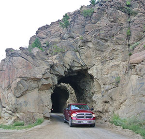
The historic Midland Railroad Tunnels are used by vehicles today along Country Road 371.
At Mile 2.5 you reach the junction with CR 375, a dirt road that heads northeast into the mountains, and then arrive at the first of three tunnels carved through the rock bluff that towers above the road. The narrow tunnels were blasted through the rock during construction of the long-abandoned Colorado Midland Railroad in the 1880s. The Midland Tunnels are so narrow that you stop, peer into them to make sure there no opposing traffic or falling rocks and then slowly proceed.
CR 371 continues as a winding dirt road in a tight canyon for the next four miles with rock formations similar to the Red Rocks of Sedona, Arizona. The few posted speed signs range from 20 mph to 35 mph. Twenty seems fast for a road so narrow, 35 death defying.
The final rock along this stretch is the largest, Elephant Rock, and then the valley opens up with rugged mountains to the right and the famed Collegiate Peaks to the left. Next to Elephant Rock is a BLM camping area. This very rustic campground does not have drinking water, electricity or trash services. But what a view! Lining the horizon is the Ivy League of high peaks; Mt. Harvard (14,420 feet), Mt. Columbia (14,073 feet) and Mt. Yale (14,196 feet) among them.
At Mile 6 is Railroad Bridge Campground, a Colorado Parks and Wildlife facility with toilets, grills, walk-in sites with tent pads and easy and quick access to the Arkansas for rafters, the reason for the changing rooms. There is also a historical display devoted to the G.A. Kelley, who staked the first gold claim in the valley in 1859 to ignite a gold rush and a century of mining along the Arkansas and its tributaries.
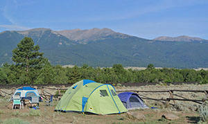
The BLM camping area at Elephant Rock in the Arkansas Headwaters Recreation Area.
In a way it hasn’t stopped because one of the most popular outdoor activities in the Upper Arkansas is recreational mining. BLM and state land is open to gold panning – without having to stake a claim or register a permit – and you’ll see people hunched along the bank, swirling mud and gravel in the bottom of their pan, looking for a little dust, flakes or even a nugget. Trying to strike it rich while on vacation.
Beyond Railroad Bridge, the county road enters another canyon, passing more rock formations, small camping areas, put-in sites for rafters, trailheads for hikers and mountain bikers. And once again CR 371 becomes a tight avenue and at times a one-lane road.
As a pick-up truck approached me here, we both paused and then inched along at less than 5 mph to avoid scrapping each other. There were six inches separating our door handles. At one point there were rugged rocks to the right me, ready to make a mess of my sub-compact rental, to the left was a steep drop-off – with no guardrail – where at the bottom was the thunderous whitewater of the Arkansas. A miscalculation in either direction and I was doomed.
You never take your eyes off this road. You want to look at the river or scope alpine slopes for Rocky Mountain bighorn sheep or watch a fly fisherman battle an 18-inch rainbow … you pull over. Somewhere.
Eventually CR 371 makes a sharp turn to the left, crosses the river on narrow bridge, passes somebody who has a Burlington Northern Railroad caboose in his front yard (obviously zoning laws aren’t a big deal out here) and at Mile 10 arrives at paved US-24.
I pulled over, unpeeled my fingers from the steering wheel and let out a deep breath. What a way to spend an afternoon. And I was less than 10 miles from the lodge I was staying at in Buena Vista.

