H58 – The Adventurous Road To Pictured Rocks
Editor’s Note: Finally we’re starting to get back to what we do best; cover trails and parks in Michigan. The re-launch of MichiganTrailMaps.com has been a time-consuming experience and we still haven’t worked out all the bugs. But please check out the new site and let us know what you think. Meanwhile here is the first Trail Talk blog since the re-launch in which Jim DuFresne writes about H58, the county road to adventure.
By Jim DuFresne
When my kids were young and we were about to cross the Mackinac Bridge, I’d hand them a bag of peanut M&Ms, slap the Little Mermaid hit, Under The Sea, into the cassette deck and then begin that 5-mile journey across Big Mac.

Jim DuFresne
It was like being at a drive-in theater. For the next 10 minutes while munching M&Ms they were filled with awe – this is the most spectacular drive in Michigan where you can see two peninsulas and two Great Lakes – and a little apprehension – you had to look twice to see those guardrails – thus my choice of theme music. When we safely arrived on the north side they knew the Upper Peninsula was truly some place special.
I would only reconfirm that belief by finding a narrow, rutted dirt road that wound past trails, lakes, waterfalls and campgrounds but little or no commercial development. A road you could follow – admittedly slowly – for a day or two with a better chance of seeing a bear run across it then a gas station open along it. A road with a canopy so thick overhead that at times they thought the forest would never end.
A road like H58.
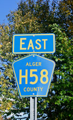
County Road H58 serves as the access to Pictured Rocks National Lakeshore.
H58 is a county-designated road that that stretches 69 miles across the northern half of Alger and Luce Counties from Munising to Deer Park. They began building it in the late 1920s and within 10 years it had been extended to Grand Marais and beyond.
It would have remained just another obscured dirt road in the U.P. except in 1966 President Lyndon Johnson signed landmark legislation that made Pictured Rocks America’s first National Lakeshore. H58, a twisty, rutted road, where often you could drive no faster than 25 mph, was the only way to reach most of this new national park.
Eventually the western half out of Munising was paved but the rest of H58 remained wonderfully rugged. The asphalt ended just past the park’s Grand Marais Visitor Center and from there you followed H58 west past the Grand Sable Dunes on one side and Grand Sable Lake on the other, at times having to blast through mounds of sand that drifted onto the gravel. Just pass the famous Log Slide, where loggers use to slide the cut timber down a dune into Lake Superior, H58 descended sharply into a forest so thick it formed a tunnel of foliage.
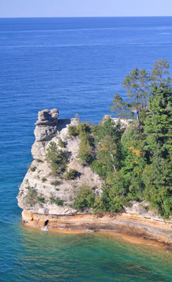
Famous Miner’s Castle, reached from H-58.
It was such a sharp and sudden descent that those driving trailers and RVs over 25 feet long were urged to turn back. It was here at this precipice that my kids and I developed our favorite saying in the U.P. When you couldn’t see where a road bottomed out it was like being at the top of our favorite roller coaster ride at Cedar Point.
“Pause, pray and plunge!” we said and then down we went.
When we reached the rustic campgrounds at Hurricane River or Twelve Mile Beach, where it was possible to set up a tent overlooking the endless blue of Lake Superior, we felt like we were on the edge of the world. And thanks to H58, we were.
All that changed in 1998. After years of legislative wrangling in Washington D.C. Congress rescinded the requirement that the National Park Service build its own access road to the park and opted for the cheaper solution of allowing the agency to help fund improvements to H58 instead. The paving of the final 20 miles of the county road was a massive effort that took five years and cost $14 million that ended with a ribbon-cutting ceremony in October, 2010.
Now smooth from Grand Marais to Munising, the improved H58 reduced travel times between the two gateways to Pictured Rocks from 90 to 45 minutes. It allowed recreational vehicles 30 or 40 feet long to access almost every part of the park and it reduced the time day hikers needed to reach trailheads for a walk to Lake Superior.

Grand Sable Dunes as seen from the Log Slide.
Traffic increased immediately but not everybody was happy. Locals were concerned about rampant commercial development overwhelming a national park that’s basically long and thin. Not long after the ribbon was cut somebody scattered thousands of nails on the road in protest that resulted in flat tires to more than 60 vehicles and trucks.
Last week I drove H58 for the first time since it was paved. I discovered getting into the interior of the park is now considerably easier and because of the asphalt realized this will become one of the most scenic drives in the U.P. for many visitors.
But have we improved H58? With every tight curve that was straightened out and every tree that was cut to expand the sightline we lost a bit of the adventure that came when following this road. Don’t get me wrong, H-58 is still scenic. It’s just not quite the thrill that my kids and I were looking for when we crossed the Mackinac Bridge.


Jim,
I have mixed feelings as someone who enjoyed the old road many times on a dual sport motorcycle, this fall I was able to take my 81 year young cousin to visit and share with me the beauty that is Pictured Rocks National Lakeshore. That would not have happened on the old road.
Cheers, Al Stover
Indian Valley Campground
PS, need to get you to Barry County sometime to enjoy some of the many great hikes available.
Check out the Chief Noonday Chapter of the NCT website for ideas. 😉