Living on the Edge of the Grand Canyon

The Lakeshore Trail map.
In this Trail Talk blog entry Jim DuFresne writes about one of the great natural wonders of the world, the Grand Canyon, and seeing it with somebody with a fear of steep drop-offs.
Another spectacular area with some steep drop-offs is Pictured Rocks National Lakeshore in the Upper Peninsula, the focus of our newest map. The 11 by 17-inch, two-sided map covers the park’s Lakeshore Trail in full color and the kind of detail you’ve come to expect from MichiganTrailMaps.com. The 42.4-mile path along Lake Superior is part of the North Country Trail and often called the most beautiful trek in Michigan. You can order the new map from our e-shop beginning April 7.
By Jim DuFresne
A friend and I were in the southwest corner of California for a wedding when after the ceremony we realized that we had three spare days, a rental car and no plans. “Let’s go to the Grand Canyon,” he said. “It’s on my bucket list.”

Jim DuFresne
My first inclination was to say I’ve been there already – twice in fact – but then I thought, it’s the Grand Canyon. You cannot witness Mother Nature’s greatest sculpture enough times in your life. We went.
We drove northeast towards Phoenix and then due north. We left I-17 for a side road through the Red Rock Country around Sedona and then north of Flagstaff skirted 12,637-foot Humphreys Peak, Arizona’s highest point. It was past 7 p.m. when we finally entered Grand Canyon National Park and pulled into the visitor center.
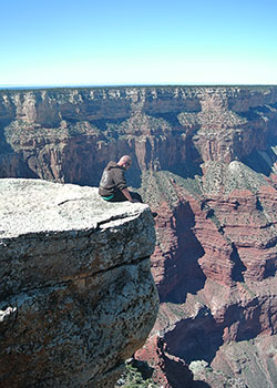
With only a few red slivers of sunset left on the horizon we hustled to nearby Mather Point, a narrow rock outcropping that juts out from rim for a nearly 360 degree view of the canyon. I turned to him to say “isn’t this amazing?” when I realized Steve was 50 yards shy of the edge of the rim, almost in the pines. “I don’t like steep edges and sudden drops,” he said.
“And you’re telling me this now,” I said in amazement. “That’s pretty much what the Grand Canyon is, you know, a big drop off.”
Taking in a view of the Grand Canyon.
Is it ever. The park’s North Rim sits at 8,255 feet. The Colorado River, looking like a ribbon of green at the bottom, is at 2,400 feet. That’s a drop of more than a mile. Stretching between the South Rim and the North Rim is a jagged landscape of buttes, mesas, side canyons and rocky formations with names like Buddha Temple, Cheops Pyramid and Freya Castle.
The other amazing aspect of the Grand Canyon is that there is no hint at what lies on the edge of the rim, even when you enter the park. From the San Francisco Peaks Range on the north side of Flagstaff, the land soon flattens out into a high plateau covered with a scattered forest of spruce and fir. At this point you see neither mountains nor a canyon.
At the visitor center there is still no indication of what is just around the corner. It is a 10-minute walk from the parking lot to Mather Point and then suddenly what was flat and forested opens up into a colorful chasm that immediately boggles the mind. Standing on the rim of the Grand Canyon is like reaching a high peak. Staring at so much landscape makes you realize how insignificant you are in the overall scheme of life.
Most hikers arrive at the Grand Canyon with a desire hike into it. Backpackers want to spend the night at the bottom either at Bright Angel Campground or at Phantom’s Ranch if they were able to reserve a room at the historic lodge in advance.
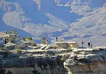
Living on the edge of the Grand Canyon.
From the rim a walk to the bottom looks deceivingly easy. But the trails to the Colorado River are narrow, steep in places and offer little shade. The hike back up is a never-ending ascent that takes twice as long. The South Kaibab Trail is the shortest route to the bottom at 6.8 miles. Bright Angel Trail is an easier descent but longer at 9.3 miles. Either way it’s a 11- to 14-hour round-trip trek to the floor of the canyon, the reason park rangers have to rescue more than 250 hikers a year.
With only one full day and a travelling partner with a case of acrophobia, I wasn’t hiking anywhere below the rim much less the bottom. Instead I spent the morning on the Rim Trail, the 13-mile long path that skirts the South Rim from South Kaibab Trailhead to Hermits Rest. Most of it is paved. The exception is the 3.1-mile portion from Powell Point to Monument Creek Vista.
This stretch is so close to the edge of the rim it was impossible for the park to lay down asphalt. It’s so scenic that almost every step is a different view of the rock formations and serrated gorges below. It’s easy to become so swept up by the panoramic views you forget you’re only a few feet from a 400-foot drop.
There was no way Steve was hiking the Rim Trail, especially the unpaved portion, after hearing that a Texas man fell 350 feet to his death trying to retrieve his hat the week before.
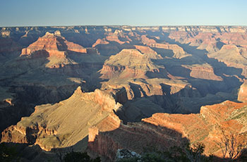
Sunset over the canyon.
Which was okay. Because of the overwhelming number of visitors, almost 5 million a year, the park maintains a free bus system that picks up and drops off at every major viewing point along the Rim Trail. I arrived at Hopi Point on foot and there Steve was, admiring the view from a bench well away from the edge. “I can see the canyon just fine from here,” he said and I’d replied “See you at Mohave Point.”
While the canyon is beautiful during the day, it can be spectacular at sunset or sunrise. At those precious moments, this entire amphitheater takes on colors, hues and shadows that are changing by the minute. We returned to Mohave Point and joined a crowd of 60 to watch the nightly performance. I selected a picnic table not more than 10 feet from the edge, an edge with no fence or railing.
At the climax of the evening the sun was perfectly balanced on the North Rim to the west while to the east buttes and mesas were turning deep shades of red and purple as if I was looking through a kaleidoscope. The scene was so mesmerizing that I didn’t realize somebody had joined me at the table. Steve had momentarily conquered his fear of steep edges. That’s how powerful the sunset was.
“Well, that’s off my bucket list,” he said and I congratulated him and said maybe next time we can hike to the bottom. Or maybe not.

