320

Trails Reviewed

Find Trails & Maps

Search for Trail
Search by Location
Search by

Back to listing

Allegan SGA: South Swan Creek Loop

Trail Details

County
Allegan
Regions
Lake Michigan
Latitude
N 42° 33' 5.04"
Longitude
W 085° 59' 3.84"
Distance
5.8-mile loop
Trail Type
Foot path
Terrain
Swan Creek and Swan Creek Pond
Difficulty
Moderate
Nearest City or Town
Allegan
(map loads here)
view map
South Swan Creek Loop is part of a 30-mile network of foot trails in Allegan State Game Area and begins and ends at M-118th Avenue dam that actually divides the Swan Creek Trail into two loops. South Swan Creek Loop is the more popular and scenic trek where a 5.8-mile trail skirts Swan Creek Pond to 116th Avenue, then returns on the pond’s other side.
Expand All
Photos
Description
South Swan Creek Loop is best done during the off-season—either in early May when fiddleheads are popping through the forest floor and the flowering dogwood is in full bloom, or in the fall, when one can witness one of the largest migratory gatherings of waterfowl in the state. In mid-July, you’ll find the wildlife scarce, the fishing slow, and the mosquitoes and black flies ferocious.

The route described here is part of a 30-mile network of foot trails in Allegan State Game Area and begins and ends at M-118th Avenue dam that actually divides the Swan Creek Trail into two loops. South Swan Creek Loop is the more popular and scenic trek where a 5.8-mile trail skirts Swan Creek Pond to 116th Avenue, then returns on the pond’s other side.

A woods road parallels much of the west side of the loop but is rarely noticed. The road, sandy, rutted, and rough, has little traffic and stays along the top of the bluff, while the trail stays closer to the pond and creek. There seems to be little mountain bike activity here, nor, in fact, are there many human intrusions of any kind, a rare occurrence in this corner of the state.
Amenities & Services
Difficulty - Moderate
Dog Friendly
Foot Path
Trail Guide

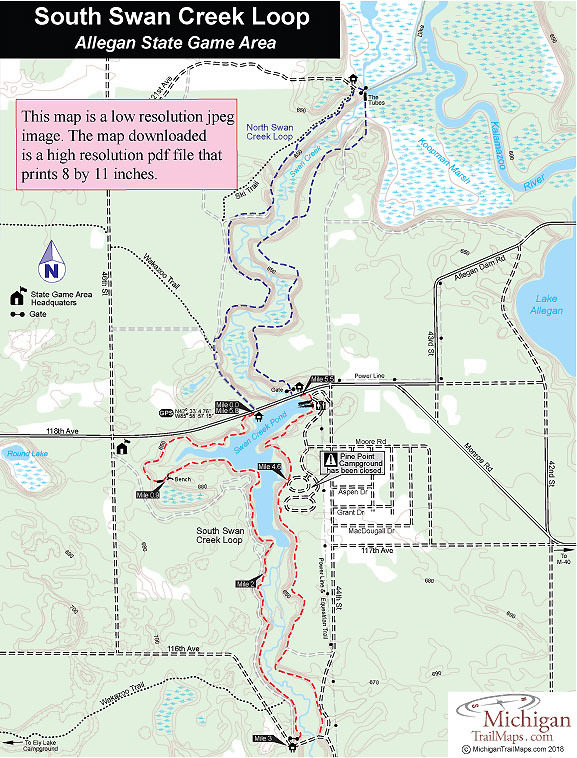
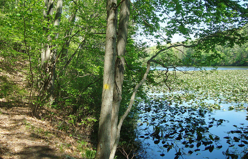
From the parking area and trailhead on the south side of 118th Avenue, the trail – marked by yellow blazes -  quickly descends the bluff and reaches the edge of Swan Creek Pond. There is a very short trail to the left when you get to Swan Creek Pond, but the main trail heads heads west (right) here, skirting the edge of the large impoundment. For 0.3 mile, you follow the shoreline of a long inlet on the pond’s west side that is carpeted in lily pads. The trail then climbs and passes within sight of the guardrails along 118th Avenue before swinging into the woods to skirt the marsh that surrounds the inlet at its west end. At Mile 0.9, you descend to cross a footbridge over a small creek, pass a bench and return to the water on the opposite side of the inlet.

The trail skirts the edge of the main portion of the pond for a very scenic if somewhat muddy stretch at times and within a 0.3 mile there is two-track is above you. The trail parallels the sandy lane for the next mile but it’s rare to hear traffic on it and impossible, from this angle, to see any.

The trail skirts near the edge of the pond for a moderately hard walk and then at Mile 2 climbs steeply to the river bluff to the two-track. At this point South Swan Creek Trail merges with the two-track and hikers follow it south to a trailhead and parking area where a red gate that blocks vehicle traffic from 116th Avenue. The two-track skirts the edge of the bluff, providing views into the river valley below during early spring and fall. Occasionally you’ll see a blue DNR pathway triangle in a tree, indicating the two-track doubles as a ski trail in the winter.

Within a quarter mile of the red gate, you come to a post marking the junction with the Wakazoo Trail. Also referred to on maps as the Cross Country Foot Trail, this path heads west 3 miles to Ely Lake Campground. South Swan Creek Loop, however, continues south and at Mile 3 emerges at 116th Avenue, a well-graded gravel road.

Head left on 116th Avenue to cross Swan Creek and on the east side look for a sign with a yellow arrow arrowed sign marking where the trail departs the road. The return walk north begins by paralleling 44th Street briefly and then climbing the bluff for a glimpse of the river below. At Mile 3.8 you pass a turnaround at the end of a woods road.

To the north the trail remains on top of the bluff most of the way to the former Pine Point Campground and is marked by yellow blazes. The social trails that head west to the creek and pond are not. The rustic campground was closed in 2016 but at Mile 4.4 you skirt close to one of the loops to the east (left) while spur trails lead west (left) to Swan Creek Pond. The trail remains within view of the water and whatever waterfowl or wildlife the pond attracts.

Beyond the campground you round Pine Point itself and, from its north side, can view the dam and 118th Avenue above it. The final leg of the loop consists of crossing the access road to the boat launch, then climbing up to the paved road. Head left on 118th Avenue but be careful, it can get busy with traffic at times. Your car is now 0.3 mile west (left) on 118th Avenue.

Facilities

There are no sources of drinking water or toilets at the trailheads. Older maps show a Pine Point Campground but the rustic facility was closed in 2016. The nearest campground is Ely Lake Campground 3 miles to the west.

Hours & Fees

The trail is open year round and is close to the southern half of the Allegan Ski Trail.

Directions

The state game area lies just west of the town of Allegan, which is almost halfway between Grand Rapids and Kalamazoo. It is reached by departing US-131 onto M-222 (exit 55) and heading west 10 miles. In Allegan, the state road merges with M-89, which should be followed north to Monroe Road on the edge of town where there is a state game area directional sign.

Travel west on Monroe Road, a scenic drive that curves around Lake Allegan, for 7 miles. You then merge with 118th Avenue and reach the dam. On the east (near) side of the dam is a parking area and trail sign for the northern loop. Just up the hill on the west side of the dam is a parking area and trailhead for South Swan Creek Loop.

Information

A half mile from the South Swan Creek Trailhead is the is the state game area headquarters (269-673-2430), where additional information can be obtained.


Geo-referenced maps from MichiganTrailMaps.com range from $1.99 to $2.99 each.

Download the Avenza app from the App Store or Google Play

App Store Google Play

Michigan TrailMaps.com Michigan's Premier Trail Resource Contact

Trail Mix News

by travel and outdoor writer Jim DuFresne!

Sign Up
Enews Signup
Find a Trail

Find Trails & Maps

Search for Trail
Search by Location
Search by