320

Trails Reviewed

Find Trails & Maps

Search for Trail
Search by Location
Search by

Back to listing

Kehl Lake Natural Area


Buy the Geo-referenced map
for use in the Avenza Maps App

Trail Details

County
Leelanau
Regions
Northwest
Latitude
N 45° 10' 11.28"
Longitude
W 085° 35' 45.60"
Distance
2.1 miles
Trail Type
Foot path
Terrain
Kehl Lake, old growth white pines
Difficulty
Easy
Nearest City or Town
Northport
(map loads here)
view map
Avenza Maps
Geo-referenced maps from MichiganTrailMaps.com are available through Avenza Maps and range from $1.99 to $2.99 each.

Download the Avenza app from the App Store or Google Play

App Store Google Play

The 279-acre Kehl Lake Natural Area north of Northport features 2,500 feet of undeveloped shoreline along the 74-acre lake, paths that wander through an extensive hardwood-conifer swamps and excellent birding, including the opportunities to spot a blue-headed vireo or Blackburnian warbler. But for many visitors the most impressive sights are above them; old growth white pines and towering hemlocks whose needles and branches reach for the sky. Even the preserves Old Birch, whose branches hasnt spouted foliage in years, makes you pause and wonder at its massive trunk.
Expand All
Photos
Description
The 279-acre Kehl Lake Natural Area north of Northport features 2,500 feet of undeveloped shoreline along the 74-acre lake, paths that wander through an extensive hardwood-conifer swamp and excellent birding, including the opportunities to spot a blue-headed vireo or Blackburnian warbler. But for many visitors the most impressive sights are above them; old growth white pines and towering hemlocks whose needles and branches reach for the sky. Even the preserve’s “Old Birch”, whose branches hasn’t spouted foliage in years, makes you pause and wonder at its massive trunk.

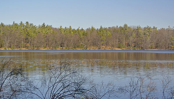
The lake and the trees first captured the attention of Ottawa and Chippewa tribes who used the area for seasonal settlements and called it “Medahas-ah-eegan” or Leg Lake, a name still seen on maps today. In 1860s, John and Elizabeth Kehl arrived from Buffalo, New York and built a cabin and farmed a 160-acre homestead along the southern half of the lake. Eventually, Leg Lake became known as Kehl Lake.

But much of the area is a mixture of wetlands and lowland hardwoods and conifers surrounded by poorly drain soils, not well suited for farming and thus never disturbed. What attracted the Leelanau Conservancy were trees unaltered by human activity and the importance of Kehl Lake as part of a wildlife corridor that spans across the tip of the Leelanau Peninsula, from Northport Bay to Cathead Bay, and Cathead Point to Lighthouse Point.  Following the conservancy’s original purchase of 113-acre Kehl Farm in 1990 the preserve has been expanded three times to its current size in an effort to protect a corridor that includes three other conservancy parcels and Leelanau State Park.

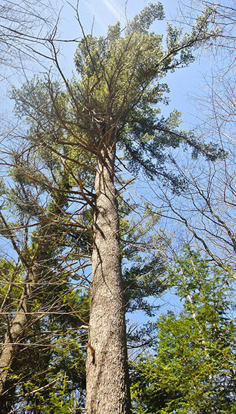
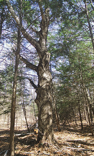
Though some eastern white pines are estimated to be more than 200 years old, the trees are not the old growth giants seen elsewhere in Michigan as fluctuating water conditions never allowed any one species to dominate.  The older white pines range 100 to 120 feet in height but feature huge trunks often three to four feet in diameter. Other species of impressive sizes include white cedar, hemlock, black spruce, beech, paper birch and sugar maple.

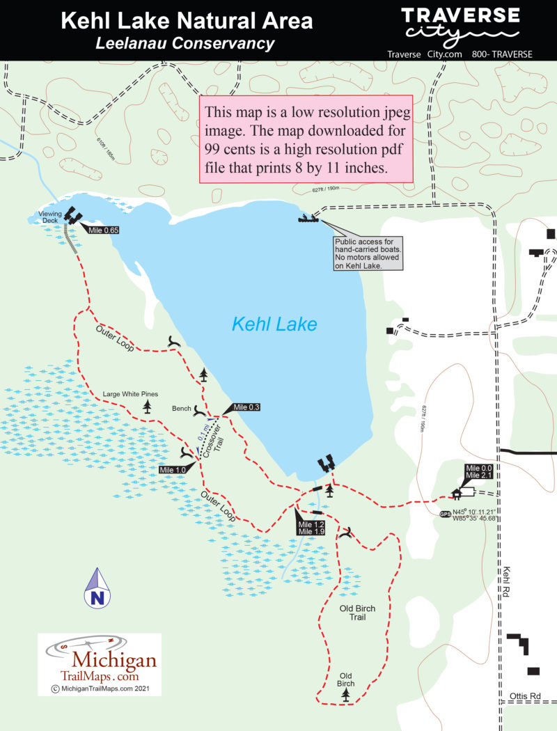
The trail system at Kehl Lake includes two loops; the 1.4-mile Outer Loop and the Old Birch Trail a loop of less than a mile from the trailhead, along with a crossover spur. This 2.1-mile hike is a combination of both loops and includes the Kehl Lake viewing dock. Most of the year the footing is dry but in early spring snow can linger in the woods and parts of the trail can be flooded with runoff.
Amenities & Services
Difficulty - Easy
Foot Path
Trail Guide

From the trailhead the trail passes through a small meadow and then enters the woods to quickly arrive at the south end of Kehl Lake. The lack of development, ban on boat motors and the surrounding wetlands has resulted in the lake’s exceptional water quality and clarity.

In less than a quarter mile you cross a bridge over a small stream feeding into Kehl Lake and arrive at the junction with the return trail from Outer Loop. Stay right to follow the west shore of the lake. The trail passes glimpses of the water through the trees and some of those ancient white pines. Within a third of a mile you pass the junction with the Crossover Trail and at Mile 0.4 arrive at where the trail swings close to the lake where a bench has been located.

At this point the trail swings west and shortly arrives at the spur to the observation dock. This area can be wet but the worse of it is crossed on planking that reaches the long dock at Mile 0.65 at the north end of Kehl Lake. During the spring and fall migrations this is a great spot to hang out with a pair of binoculars.

Backtrack to the junction and continue following the Outer Loop to the right. The trail skirts the lowland forested wetlands but stays dry and just before the junction with the Crossover Trail at Mile 1 passes another old growth white pine. At Mile 1.2 you arrive at the junction with the Old Birch Trail, a trail that was built in 2006 and adds 0.7 miles to the hike. If followed in a clockwise direction you quickly pass a bench at the junction with the return trail and then in a third of mile arrive at the Old Birch, now dead but whose giant trunk stands as a monument to the species.

You return to the Outer Loop at Mile 1.9 and backtrack to the trailhead and parking area.

Facilities

You can’t launch a boat from the natural preserve but canoes and other hand-carried boats can be launched at a public access near the north side of lake at end of Kehl Road.

Hours & Fees

In the winter, the preserve’s gentle terrain is a popular with cross-country skiers.

Directions

From M-22 head north on M-201 through downtown Northport and then continue after the state highway becomes County Road 640 (Woolsey Lake Rd). Within 2.5 miles of Northport turn north (left) on Snyder Road and then east (right) on at Sugar Bush Road. Sugar Bush Road takes a sharp left turn to the north and becomes Kehl Road.  Stay on Kehl Eoad and within 0.7 miles or a quarter mile past Ottis Road, is the posted entrance to Kehl Lake Natural Area on the left.

Information

For more information contact the Leelanau Conservancy (231-256-9665; leelanauconservancy.org) or stop at the conservancy office, 105 North First St., in Leland. The office is open 8:30 a.m. to 5 p.m. Monday through Friday.

For lodging or travel information contact Traverse City Tourism (800-872-8377; www.traversecity.com).


Geo-referenced maps from MichiganTrailMaps.com range from $1.99 to $2.99 each.

Download the Avenza app from the App Store or Google Play

App Store Google Play

Michigan TrailMaps.com Michigan's Premier Trail Resource Contact

Trail Mix News

by travel and outdoor writer Jim DuFresne!

Sign Up
Enews Signup
Find a Trail

Find Trails & Maps

Search for Trail
Search by Location
Search by